


Description
Historical Context
Since the 16th century the County of Gorizia and Gradisca, today divided between Italy and Slovenia, belonged to the Austrian Habsburgs. The picturesque country, now a popular tourist destination, contained Slovenian and Italian speaking inhabitants, with a vast majority of the latter identifying themselves as Friulans, speaking a distinct dialect.
The governmental institutions, schools and local banks were, similarly as in Tyrol, run by the Austrians, forcing the local population to adjust to German programs in school and official issues, and leaving them with only little choice to gain higher education without moving to larger cities, such as Trieste and Vienna.
By the late 19th century Austro-Hungary was in crisis with various ethnic groups within striving for independence of their own language and eventually their own states. This spirit also affected the rural Italian speaking population of Gorizia and Gradisca, where at the time many farmers owed money to Austrian banks. Very soon local pro-Italian, anti-Vienna movements developed in the area, with nationalistic demands, such as foundation of Italian University in Trieste. An important move was the first rural fund, located at Capriva, a village east of Gorizia, run by the villagers and founded after the great flood of 1896, which affected many local farmers with no help from the government.
In 1915, when Italy entered World War I against Austria-Hungary, the County of Gorizia and Gradisca became a theater of war between the two countries, with a fierce front on the Isonzo river, dividing the population and local politics. In 1916, for the first time in history Gorizia was occupied by Italy.
After the war the Friulians, occupying mostly the Western part of the country, demanded autonomy of the region and eventually joined Italy, as the Slovenians on the Eastern part wanted to join the other South Slavs, the formation which would after the fall of Austro Hungary become the Kingdom of Yugoslavia.
The Maps in Focus
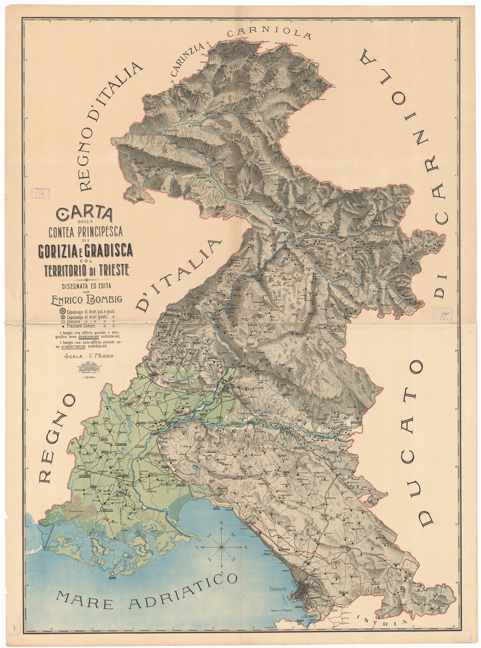
The present large-format, detailed maps show Gorizia with its surroundings and the Princely County of Gorizia and Gradisca, embracing the area of the Isonzo River
and also showcase Trieste in the lower part, ending with Muggia, the border between the Austro Hungary and Venetian Republic. The maps are made of papier-maché, presenting the areas in three dimensions, and are surrounded with frames and supported with original wooden boards verso.
The date 1904 on one of them, titles in Italian and a signature E. Bombig, a family name typical for the Gorizia area, more precisely the village Farra d’Isonzo, just north of Gradisca (please see the next chapter for details), suggests, that the maps were probably made for one of the newly founded Italian-speaking organizations, which became a center for education and funding of local farmers in the last years of the 19th century. The maps clearly show the geography, with all the villages, even separate houses, roads, mountains and rivers.
Cartographer Enrico Bombig
Enrico Bombig, who signed both present maps, authored another similar printed map of the same territory, titled Carta della Contea Principesca di Gorizia e Gradisca col territorio di Trieste. The map was printed in at least two states, in 1904 and 1905, by Officina Arti Grafiche E. Passero in Udine and marks various administrative centers and postal offices
(click here for the images: B0005720.jpg (1605×2163) (igmi.org) and Archivi Catalogo – R’accolte – ACRI).
The printed map is with its dimensions (134 x 95 cm) very similar to our tridimensional version (136 x 108 cm).
In 1905, a Slovenian same-large-size version of the map was published in Gorizia under a translated title Zemljevid poknežene grofije Goriško-Gradiščanske s Trstom in okolico. The map was published with and without advertisement for two different prices and was, according to the ad, intended for public premises, restaurants, associations and offices.
In the same period Enrico Bombig also authored a wall-map of Istria with Gorizia and Gradisca, titled Carta dell’Istria, città e territorio di Trieste. Città e distretto di Fiume. Friule altipiano del Carso e litorale della Croazia (Map of Istria, City and Territory of Trieste. City and District of Rijeka. Friule Karst Plateau and Croatian Coast) with marked population and nationalities (click here for details: Carta dell’ Istria : città e territorio di Trieste : città e distretto di Fiume / disegnata da Enrico Bombig. (nsk.hr)).
Unfortunately, not many researches have been made on Enrico Bombig, his education and other work.
His surprisingly sophisticated large-format maps can be connected with another person of the same family name, Antonio Bombig, possibly Enrico’s father or a close relative.
Antonio Bombig (1819-1896) from the same village, Farra d’Isonzo, authored in the 19th century at least three large globes, one of which today survives at Villa Manin di Passariano as a part of a collection of Museo Civico in Udine (Peter E. Allmayer-Beck, Modelle der Welt: Erd- und Himmelsgloben, 1997, p. 248). The globe measures 86 cm in diameter, is dated 1873 and is special in many ways. Antonio Bombig invented a special technique to lift the globe on it stand and “adapted to the globe the system used to mould cheese by using strips of beech bent to form a circle” (Franco 1993, p. 186). The surface is hand-coloured and the names are made in manuscript.
In 1890, Antonio Bombig authored a manuscript map of his home village Farra d’Isonzo (Paolo Iancis, 100 anni di credito cooperativo a Farra, 2003, pp. 8-9).
The family name Bombig is typical for the area around Gorizia, mostly for the village Farra d’Isonzo. Several members of the family, including one Enrico Bombig, possibly identical to our cartographer, as well as Antonio Bombig were on boards of Italian speaking newly founded organizations for funding and better organization of local communities (Nino Agostinetti, La Cassa Rurale ed Artigiana di Lucinico Farra e Capriva 1896-1983, 1984).
.
Probably most famous member of the Bombig family is Giorgio Bombig (after 1929 Bombi, 1852 – 1939), born in Gorizia, who was an extreme supporter of Italianism in the area. After the war he became a mayor of Gorizia and was later awarded under the Fascist regime.
A Note on Rarity
All Enrico Bombig’s maps are very rare and the present two maps are his only unique works, that we could trace in institutions or on the market.
Bombig’s work is exceedingly important for history of Friuli, the Valley of Isonzo and Slovenian and Croatian coastal regions and for the Italian national awakening in the area, as well as for history of Slovenians.
NOTE: Shipping for the two maps is not included in the price. Please inquire for details of the transportation and prices. We would be happy to find the most accomodating possibility.
References: Cf.: Loredana Franco, The Old Globes in Friuli-Venezia Guilia (Italy), Instituto e Museo di storia dalla Scienza, Firenze. Nunzius. Annali di Storia della Scienza, VIII, 1993, fasc. 1, pp. 169-195, abb. 2; Codroipo: Inventario dei beni culturali del comune, 1996, p. 88, no. 899; Peter E. Allmayer-Beck, Modelle der Welt: Erd- und Himmelsgloben, 1997, p. 248.
![ZAGREB: Nacrt Zagreba. Sestavio: Za načelnikovanja arhitekta Vjekoslava Heinzela Gradski gradjevni odsjek [Plan of Zagreb: Made at the time of mayor architect Vjekoslav Heinzel by the Urban Planning Office].](https://pahor.at/wp-content/uploads/2020/06/65688a-265x331.jpg)
![SPAIN – BADAJOZ / NAPOLEONIC WARS MANUSCRIPT MAP: [Untitled Manuscript Plan of the Siege of Badajoz (1812)].](https://pahor.at/wp-content/uploads/2020/06/65676-265x331.jpg)

