-
- Balkans, Europe, Maps and Prints, Middle East, Turkey
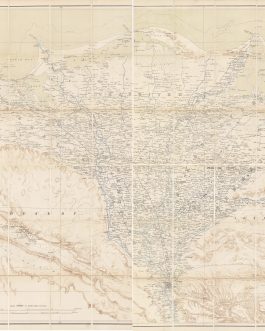
DISTANCE-TIME-ROUTE MAP / OTTOMAN EMPIRE: ممالك محروسه شاهانه [Imperial Guarded Domain…]
- 3,500.00€
- The very first distance-time-route map of the Ottoman Empire, one of the great masterpieces of Hamidian Era thematic cartography, it depicts the entire realm of the Sublime Porte from Albania to Yemen, noting the travel times between hundreds of locations, including various routes of the Hajj; devised by the General Staff of the Ottoman Army and published in Istanbul.…
- Add to cart
-
- Africa, Books, Geography, Maps and Prints, Middle East
Egypt Atlas: اطلس ابتدائى للقطر المصرى [Elementary Atlas of Egypt].
- 2,800.00€
- A very rare and important Arabic language school atlas of Egypt, commissioned by the country’s Education Ministry and Ministry of Finance, emblematic of the country’s emerging national awakening whereby Egyptians gradually regained control over their country’s economy and institutions from the British quasi-colonial regime; in this vein, such cartographic works in the Arabic language, made for the use of…
- Add to cart
-
- Iran, Maps and Prints, Middle East
IRAN: كشورشا هنشاهى ايران [The Country of Iran]
- 3,200.00€
- 4 sheets, not joined, colour lithographs. Each sheet circa 95 x 111 cm (37.4 x 43.7 inches), if assembled: circa 180 x 203 cm (70.8 x 80 inches). Small tears and holes in folds and margins, tiny creases on surfaces, old repairs, partly with postal slips from 1984 in English language, and traces of tape, later annotations in the…
- Add to cart
-
- Maps and Prints, Middle East
IRAQ / IRAN – PETROLEUM (OIL) HISTORY / DIPLOMATIC HISTORY: [A Complete Collection of the 3 Official Maps (on 4 Sheets) certifying the Ottoman-Persian Boundary Survey by the Shatt Al-Arab Waterway, along today’s Iraq-Iran Frontier, according to the Anglo-Turkish Declaration of July 29, 1913].
- 1,800.00€
- Extremely rare – the complete series of the 3 maps (on 4 sheets) of the Ottoman-Persian Boundary Survey in the vicinity of the Shatt Al-Arab waterway, along today’s Iraq-Iran frontier, above the head of the Persian Gulf, as mandated by the Anglo-Turkish Declaration of July 29, 1913; this boundary settlement was surveyed by Indian Army engineers under the supervision…
- Add to cart
-
- Maps and Prints, Middle East, Newly Catalogued Items: August 2022
IRAQ / KUWAIT / IRAN / PETROLEUM HISTORY / WORLD WAR I: Lower Mesopotamia between Baghdad and the Persian Gulf.
- 980.00€
- The rare first edition of the first accurate and highly detailed topographical general map of Central and Southern Iraq, Kuwait and Khuzestan (Iran), created by the British War Office, the culmination of three generations of espionage and exploration missions, capped by late breaking discoveries; the authoritative map used by both sides during World War I’s ‘Mesopotamia Campaign’, Britain’s dramatic…
- Add to cart
-
- Maps and Prints, Middle East
Iraq WWI – Mesopotamia Campaign Siege of Kut Al-Amara Ottoman Military Field Cartography “Captured” Enemy Map: [Iraq WWI – Mesopotamia Campaign. Siege of Kut Al-Amara]
- 3,600.00€
- A fascinating artefact of World War I’s Mesopotamian Campaign – an Ottoman map of the vicinity of the Siege of Kut al-Amara, one of the conflict’s most dramatic events and one of the greatest defeats in British Imperial History; crudely lithographed in theatre by Ottoman engineers, based upon a “captured” British map that was itself based on fresh, detailed…
- Add to cart
-
- Maps and Prints, Middle East
ISFAHAN / IRAN: Guide Map of Isfahan
- 220.00€
- Colour print, 73 x 60 cm (28.7 x 23.6 inches), verso text, illustrations, photograph and a map (soft folds, otherwise in a good condition).
- Add to cart
-
- Maps and Prints, Middle East, New Acquisitions: September 2020
Kuwait / Iraq (Basra) / WWI Middle East / Important Ottoman Cartography: بصره [Basrah].
- 3,500.00€
- Very rare and historically important – the most detailed and accurate Ottoman map of the Kuwait and the Basra region of Iraq, issued by the General Staff of the Ottoman Army for strategic and operational planning early in World War I and during the twilight of the reign of Sheikh Mubarak Al Sabah, the ‘Father of Modern Kuwait’; depicting…
- Add to cart
-
- Maps and Prints, Middle East, New Acquisitions: December 2020
LEBANON: جبل لبنان سنجاغى [Mount Lebanon Sanjak]
- 120.00€
- A map from Umûm Vilayât-ı Şâhâneyi Hâvi Küçük Atlas - Umûmî Küçük Atlas (General Small Atlas) Chromolithograph. 9 x 13,5 cm (3.5 x 5.3 inches).
- Add to cart
-
- Maps and Prints, Middle East
LEVANT & HEJAZ RAILWAY: جغرافياى عسكرى و عثمانى درسلرينه مخصوص سوريه قطعة سى
- 3,200.00€
- عثمان نورى [Osman Nuri, Sabık Coğrafya-yı Askeri Muavini Piyade Kol Ağası / Senior Chief Military Cartographer for the Infantry]. جغرافياى عسكرى و عثمانى درسلرينه مخصوص سوريه قطعة سى [Part of Syria for Specific Military and Ottoman Geographical Operations / Lessons] Inset Map: حجاز دميريولى كذركاهى [Hicaz demiryolu güzergah / Route of the Hejaz Railway] Istanbul: مكتب حربيه مطبعه سى [Maktaba…
- Add to cart
-
- Africa, Maps and Prints, Middle East
Map of Lower Egypt
- 1,800.00€
- The very rare first edition of the foundational map of the British colonial regime in Egypt; created by the Intelligence Department of the War Office on the eve of the Anglo-Egyptian War (1882), whereby Britain forcibly made Egypt a protectorate, so gaining dominance over the Suez Canal; predicated upon the best sources, the very large four-sheet work was the…
- Add to cart
-
- Africa, Maps and Prints, Middle East
MAP PRINTED ON SILK / OBJECT D’ART / ALEXANDRIA, EGYPT / NAPOLEONIC CAMPAIGN IN EGYPT: A Plan of the Operations of the British Forces in Egypt from the Landing in Aboukir Bay on the 8th of March to the Battle of Alexandria March 21st inclusive.
- 3,500.00€
- An exquisite ‘objet d’art’, being a unique example of William Faden’s map of the Battles of Abukir and Alexandria (1801), France’s ‘last stand’ in Egypt, printed on silk with details richly embroidered in coloured silk thread, clearly a prestation piece made for a highly important figure. Copper engraving on silk with details contemporarily heightened in embroidery of coloured silk thread, contemporarily…
- Add to cart

![DISTANCE-TIME-ROUTE MAP / OTTOMAN EMPIRE: ممالك محروسه شاهانه [Imperial Guarded Domain…]](https://pahor.at/wp-content/uploads/2023/04/Javajoe43-copy-265x331.jpg)
![Egypt Atlas: اطلس ابتدائى للقطر المصرى [Elementary Atlas of Egypt].](https://pahor.at/wp-content/uploads/2022/04/IMG_6334-copy-265x331.jpg)
![IRAN: كشورشا هنشاهى ايران [The Country of Iran]](https://pahor.at/wp-content/uploads/2023/06/iran-copy1-copy-265x331.jpg)
![IRAQ / IRAN – PETROLEUM (OIL) HISTORY / DIPLOMATIC HISTORY: [A Complete Collection of the 3 Official Maps (on 4 Sheets) certifying the Ottoman-Persian Boundary Survey by the Shatt Al-Arab Waterway, along today’s Iraq-Iran Frontier, according to the Anglo-Turkish Declaration of July 29, 1913].](https://pahor.at/wp-content/uploads/2023/01/Novemmap17-copy-265x331.jpg)

![Iraq WWI – Mesopotamia Campaign Siege of Kut Al-Amara Ottoman Military Field Cartography “Captured” Enemy Map: [Iraq WWI – Mesopotamia Campaign. Siege of Kut Al-Amara]](https://pahor.at/wp-content/uploads/2020/07/kut3ku-265x331.jpg)

![Kuwait / Iraq (Basra) / WWI Middle East / Important Ottoman Cartography: بصره [Basrah].](https://pahor.at/wp-content/uploads/2020/08/basra-265x331.jpg)
![LEBANON: جبل لبنان سنجاغى [Mount Lebanon Sanjak]](https://pahor.at/wp-content/uploads/2020/12/69208-3-265x331.jpg)