-
- Asia, Maps and Prints, South-East Asia
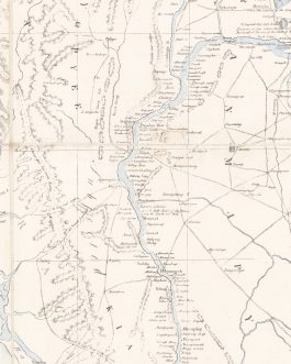
A Geographical Sketch of the Burmese Empire Compiled at the Office of the Surveyor General of India And published with Permission of Government At the Asiatic Lithographic Press / Calcutta 1825.
- 9,500.00€
- Extremely rare – the foundational modern map of Burma, being the first realistic general map of the country, as well as a monument of early lithography in India; the very large format work was published in Calcutta by the Asiatic Lithographic Press during the height of the First Anglo-Burmese War (1824-6), it served as an invaluable strategic aid for…
- Add to cart
-
- Asia, Europe, Maps and Prints, Middle East, Near East, Turkey
ARABIAN PENINSULA / OTTOMAN EMPIRE: اسياى غرب [West Asia]
- 280.00€
- Lithograph with original colour: 18 x 23 cm (7 x 9 inches) (soft fold, slightly stained in the upper margin).
- Add to cart
-
- Asia, Europe, Maps and Prints, Near East
Azerbaijan SSR: Azerbajcanın sijasi va təbii Xərıtəsi [Political and Natural Map of Azerbaijan]
- 2,800.00€
- The first wall map of Azerbaijan SSR, made in 1925 by a pioneer of Azerbaijani map-making İbrahim Ağa Vəkilov Colour lithography, printed on four sheets and originally mounted on linen, 100 x 135 cm (39.8 x 53.1 inches) (small tears, folds and holes with tiny loss of material, light staining).
- Add to cart
-
- Asia, China, Maps and Prints
CHINA – BEIJING – BOXER REBELLION: 京城各國暂分界址全图 [Jing cheng ge guo zan fen jie zhi quan tu]
- 5,500.00€
- [Complete Map of Various Foreign Countries’ Temporarily Divided Territory Boundaries within the City of Beijing.] [China, likely Beijing, no publisher, 1900]. A very rare, attractive and intriguing map, capturing Beijing during the Boxer Rebellion (1899 - 1901), when ‘Zongli Yamen’ (Legation Quarter) of the Old City was besieged by ultra-nationalist rebels, only for the barricade to be lifted by…
- Add to cart
-
- Asia, China, Maps and Prints
CHINA – HAINAN (South Coast, including Yalong Bay): A Chart of the South Coast of Hay-nan: from Tinhosa to Guichou Survey’d in 1776 and 77 By Captn. Haldane.
- 950.00€
- Very Rare – the first issue of the first large-format printed sea chart of the South Coast of Hainan, based on a reconnaissance survey conducted by John Haldane of the British East India Company, from Sayer & Bennett’s magnificent ‘The East-India Pilot, or Oriental Navigator’.
- Add to cart
-
- Asia, Books, China, Geography, Maps and Prints
CHINA – QINGDAO (TSINGTAO / TSINGTAU): Guide Book on Tsingtao and its Vicinity by Adolf Haupt. With two Maps and many illustrations.
- 1,800.00€
- Adolf HAUPT (fl. 1900 – 1933). Tsingdao [Qingdao]: Printed at the Catholic Mission Press, 1927. 8° (19 x 11.5 cm): [13 pp. advertisements, title, preliminaries], 1-48 pp., [16 pp. advertisements on coloured paper], 49-156 pp. (with 82 photographic images imbedded within text), [2 pp.], plus 2 large folding colour lithographed maps on thick paper, bound in original printed boards with…
- Add to cart
-
- Asia, China, Korea, Maps and Prints
CHINA / KOREA: Nördlicher Stiller Ozean / Ostküste von China / Gelbes Meer Nördlicher Teil.
- 2,500.00€
- OBERKOMMANDO DER KRIEGSMARINE (NAZI GERMAN NAVY HIGH COMMAND). Berlin: Dietrich Reimer (Andrews & Steiner), August 27, 1942. Photolithograph on thick paper, with the h Photolithograph on thick paper, with the handstamps of the ‘Kriegsmarinewerft Wilhelmshaven Kartengruppe’ as well as classification handstamps and a pastedown label regarding the accuracy of the chart (Very Good, overall clean and bright, some wear along…
- Add to cart
-
- Asia, China, Maps and Prints
CHINA / SHANGHAI IMPRINT: 皇朝直省地輿全圖 [Huang chao zhi sheng di yu quan tu / The Complete Geographic Map of the Imperial Provinces].
- 6,500.00€
- A rare, stellar and very large format bilingual (Chinese, French) map of China, made by Stanislas Chevalier, the polymath Jesuit-scientist who was famously the father of meteorology in China, beautifully colour lithographed at the Imprimerie Hong-pao-tchai, a printing house located at Zi-Ka-Wei, the missionary education-science centre in the Xuhui District of Shanghai, with Chinese-style blue silk endpapers, the map is…
- Add to cart
-
- Asia, China, Maps and Prints
CHINA: Map of China prepared for the China Inland Mission 1898.
- 1,400.00€
- One of the finest general maps of China produced during the fin de siècle period, a large format, highly detailed work produced as part of map sequence for the China Inland Mission (CIM) by the world leading firm of Edward Stanford, and the first issue to be predicated upon the revolutionary cartography of the Russian sinologist Emil Bretschneider, providing…
- Add to cart
-
- Asia, India, Maps and Prints
Goa, India: Carta do Territorio Portuguez de Goa correcta por J.F. d’Assa Castel Branco, Tenente d’Engenheiros em 1890.
- 2,800.00€
- A very rare, large-format separately issued map of the Portuguese Territory of Goa, India; being the finest general map of the colony issued during the second half of the 19th Century, with the present edition being the first major map to depict the entire completed line of the Mormugao Railway, Goa’s first railroad; predicated upon the stellar surveys of…
- Add to cart
-
- Asia, India, Maps and Prints
INDIA (NORTHERN) / PAKISTAN / BANGLADESH: Vicariati e prefetture Apostoliche nell’ Indostan.
- 1,500.00€
- Extremely Rare – a pair of large-format maps respectively depicting Northern and Southern India, featuring the ecclesiastical divisions of the Roman Catholic on the subcontinent, prepared for the Vatican’s State Secretariat by Girolamo Petri, issued within his monumental atlas, ‘L’Orbe Cattolico ossia Atlante Geografico Storico Ecclesiastico’.
- Add to cart
-
- Asia, India, Maps and Prints
INDIA / BURMA: 國帝度印 [The British Raj].
- 650.00€
- A rare large format Japanese map of India and Burma, ‘pirated’ from a British map by the venerable bookseller Maruzen, issued during the height of World War II, as Japan conquered Burma and before its (ultimately ill-fated) invasion of India during ‘Operation U-Go’ (1944). Colour print, folding into original printed paper sleeve (Very Good, some toning along old…
- Add to cart

![ARABIAN PENINSULA / OTTOMAN EMPIRE: اسياى غرب [West Asia]](https://pahor.at/wp-content/uploads/2022/02/2022-02-05_144645-copy-265x331.jpg)
![Azerbaijan SSR: Azerbajcanın sijasi va təbii Xərıtəsi [Political and Natural Map of Azerbaijan]](https://pahor.at/wp-content/uploads/2022/06/IMG_8802-Recovered-265x331.jpg)
![CHINA – BEIJING – BOXER REBELLION: 京城各國暂分界址全图 [Jing cheng ge guo zan fen jie zhi quan tu]](https://pahor.at/wp-content/uploads/2024/06/IMG_3529-copy-265x331.jpg)


![CHINA / SHANGHAI IMPRINT: 皇朝直省地輿全圖 [Huang chao zhi sheng di yu quan tu / The Complete Geographic Map of the Imperial Provinces].](https://pahor.at/wp-content/uploads/2023/07/Junescan17-copy-265x331.jpg)


![INDIA / BURMA: 國帝度印 [The British Raj].](https://pahor.at/wp-content/uploads/2021/08/Junemap178-copy-265x331.jpg)