Skip to content
  • My Account
  • Shopping Cart
  • Contact Us
0
Daša Pahor
  • Home
  • Books
  • Maps and Prints
    • Americas
    • Europe
    • Decorative Prints
    • History
    • Photography
  • Archives and Documents
  • News
  • About us
  • 0
  • Toggle website search
  • Home
  • Books
  • Maps and Prints
    • Americas
    • Europe
    • Decorative Prints
    • History
    • Photography
  • Archives and Documents
  • News
  • About us

Europe

  1. Home>
  2. Products>
  3. Maps and Prints>
  4. Europe>
  5. Page 3
  • View:
  • 12
  • 24
  • All
  • FIRST SOVIET HISTORICAL ATLAS / POLITICAL PROPAGANDA: Русский исторический Атлас [Russkiĭ istoricheskiĭ atlas / Russian Historical Atlas] Quick View
    • FIRST SOVIET HISTORICAL ATLAS / POLITICAL PROPAGANDA: Русский исторический Атлас [Russkiĭ istoricheskiĭ atlas / Russian Historical Atlas] Quick View
    • Books, Europe, Maps and Prints, Russia, Slavica
    • FIRST SOVIET HISTORICAL ATLAS / POLITICAL PROPAGANDA: Русский исторический Атлас [Russkiĭ istoricheskiĭ atlas / Russian Historical Atlas]

    • 2,200.00€
    •   First Soviet historical atlas, made by one of the leading historians Konstantin Kurjashov and accompanied with an introduction by a pioneering historian of the Russian revolutionary movement Mikhail Pokrovsy, glorifying Russian economy of the past and presenting the newly founded Soviet Union as a historical self sufficient formation.   Oblong folio, 12 pp. XVIII with 58 numbered maps, printed…
    • Add to cart
  • France: فرانسه Quick View
    • France: فرانسه Quick View
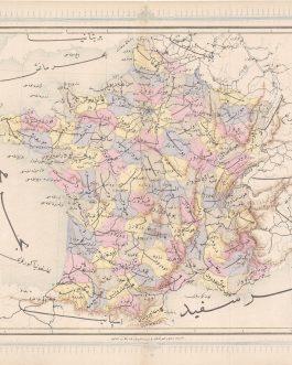
    • Europe, France, Maps and Prints
    • France: فرانسه

    • 120.00€
    • A map of France from the first Ottoman lithographed atlas.   Colour Lithography, 32 x 43 cm (12.6 x 17 inches), (soft fold slightly age-toned, minor wear to the margins, but overall in a good condition).
    • Add to cart
  • GALLIPOLI / TURKEY: چناق قلعه بوغاز [Çanakkale Boğazı / Dardanelles] Quick View
    • GALLIPOLI / TURKEY: چناق قلعه بوغاز [Çanakkale Boğazı / Dardanelles] Quick View
    • Maps and Prints, New Acquisitions: September 2020, Turkey
    • GALLIPOLI / TURKEY: چناق قلعه بوغاز [Çanakkale Boğazı / Dardanelles]

    • 120.00€
    • Chromolithographs on thick paper. Each sheet: 11 x 15 cm (4.3 x 5.9 inches). Slightly stained, overall in a good condition
    • Add to cart
  • GALLIPOLI CAMPAIGN – BATTLES OF KRITHIA (ALÇITEPE):  [Untitled Ottoman Mimeographed WWI Military Map of the Southern Part of the Gallipoli Peninsula]. Quick View
    • GALLIPOLI CAMPAIGN – BATTLES OF KRITHIA (ALÇITEPE):  [Untitled Ottoman Mimeographed WWI Military Map of the Southern Part of the Gallipoli Peninsula]. Quick View
    • Maps and Prints, New Acquisitions: September 2020, Turkey
    • GALLIPOLI CAMPAIGN – BATTLES OF KRITHIA (ALÇITEPE): [Untitled Ottoman Mimeographed WWI Military Map of the Southern Part of the Gallipoli Peninsula].

    • 420.00€
    • A rare ephemeral artefact from the Gallipoli Campaign of World War I, being a mimeographed map made in the field by Ottoman soldiers, depicting the theatre of the Battles of Krithia (Alçitepe), a series of four major altercations fought between British Imperial-French forces and the Turks between April and August 1915.   Mimeograph in purple (Very Good, old vertical centrefold,…
    • Add to cart
  • GEOLOGICAL MAP / CROATIA / YUGOSLAVIA: Geološka karta srednje in spodnje Istre s sosednjimi otoki [Geological Map of Middle and Lower Istria with the Neighbouring Islands]. Quick View
    • GEOLOGICAL MAP / CROATIA / YUGOSLAVIA: Geološka karta srednje in spodnje Istre s sosednjimi otoki [Geological Map of Middle and Lower Istria with the Neighbouring Islands]. Quick View
    • Croatia, Maps and Prints
    • GEOLOGICAL MAP / CROATIA / YUGOSLAVIA: Geološka karta srednje in spodnje Istre s sosednjimi otoki [Geological Map of Middle and Lower Istria with the Neighbouring Islands].

    • 380.00€
    •   A large, seemingly unrecorded geological wall map of South Istria and Northern Dalmatian Islands with manuscript colouring was made after WWII, when the territory was regained by Yugoslavia after more than two decades under Fascist Italian government.
    • Add to cart
  • Gigantic Wall Map of Istanbul Quick View
    • Gigantic Wall Map of Istanbul Quick View
    • Europe, Maps and Prints, Turkey
    • Gigantic Wall Map of Istanbul

    • 2,800.00€
    •   Circa 185 x 130 cm (72 x 50 inches), lithograph in colour, printed from two originally joined plates, originally mounted on linen with wooden rollers. With contemporary annotations in pencil and pen.   A rare gigantic wall map of Fatih in the European Part of Istanbul is the first official survey project of the city, made in the newly…
    • Add to cart
  • GRAZ: Plan der kaiserlich königliechen Provinzial-Hauptstadt Gratz samt ihren Umgebungen in Herzogthume Steyermark. Quick View
    • GRAZ: Plan der kaiserlich königliechen Provinzial-Hauptstadt Gratz samt ihren Umgebungen in Herzogthume Steyermark. Quick View
    • Austria, Europe, Maps and Prints
    • GRAZ: Plan der kaiserlich königliechen Provinzial-Hauptstadt Gratz samt ihren Umgebungen in Herzogthume Steyermark.

    • 450.00€
    • Add to cart
  • GRAZ: Plan der Provinzial Hauptstadt Graz im Herzogthume Steyermark Quick View
    • GRAZ: Plan der Provinzial Hauptstadt Graz im Herzogthume Steyermark Quick View
    • Austria, Europe, Maps and Prints, New Acquisitions: September 2020
    • GRAZ: Plan der Provinzial Hauptstadt Graz im Herzogthume Steyermark

    • 450.00€
    • Lithograph printed on two joined sheets 58 x 69 cm (22.8 x 27.2 inches) (minor staining, tiny tears in the margins, overall in a good condition).
    • Add to cart
  • GREECE: ΝΕΟΣ ΠΟΛΙΤΙΚΟΣ ΧΑΡΤΗΣ ΤΕΣ ΕΛΛΑΔΟΣ ΥΠΟ Δ. ΔΗΜΗΤΡΑΚΟΥ Quick View
    • GREECE: ΝΕΟΣ ΠΟΛΙΤΙΚΟΣ ΧΑΡΤΗΣ ΤΕΣ ΕΛΛΑΔΟΣ ΥΠΟ Δ. ΔΗΜΗΤΡΑΚΟΥ Quick View
    • Europe, Greece, Maps and Prints
    • GREECE: ΝΕΟΣ ΠΟΛΙΤΙΚΟΣ ΧΑΡΤΗΣ ΤΕΣ ΕΛΛΑΔΟΣ ΥΠΟ Δ. ΔΗΜΗΤΡΑΚΟΥ

    • 440.00€
    • [New Political Map of Greece under D. Dimitrakos] [Neos politikos khartis tes Ellados ipo D. Dimitraki]   Colour lithograph, 100 x 70 cm (39.4 x 27.6 inches) (soft folds, tiny tears in margins, otherwise in a good condition).  
    • Add to cart
  • HAMBURG Quick View
    • HAMBURG Quick View
    • Europe, Germany, Maps and Prints
    • HAMBURG

    • 6,500.00€
    • Add to cart
  • HAMBURG: Große Allee vor dem Steintor. Quick View
    • HAMBURG: Große Allee vor dem Steintor. Quick View
    • Europe, Germany, Maps and Prints
    • HAMBURG: Große Allee vor dem Steintor.

    • 6,500.00€
    • Add to cart
  • Hungary / Railroad Map: Magyarország vasuti térképe. Ungarns  Eisenbahnkarte [Railroad Map of Hungary] Quick View
    • Hungary / Railroad Map: Magyarország vasuti térképe. Ungarns  Eisenbahnkarte [Railroad Map of Hungary] Quick View
    • Europe, Hungary, Maps and Prints
    • Hungary / Railroad Map: Magyarország vasuti térképe. Ungarns Eisenbahnkarte [Railroad Map of Hungary]

    • 380.00€
    •   Colour lithograph, 64 x 94 cm (25. 2 x 37 inches), originally dissected in 16 segments and mounted on linen (minor staining, overall in a good clean condition).  
    • Add to cart
  • 1
  • 2
  • 3
  • 4
  • 5
  • 6
  • 7
  • 8

Filter by price

Price: —

Product categories

  • Archives and Documents (54)
  • Books (1131)
  • Maps and Prints (798)
    • Africa (81)
    • Americas (54)
    • Asia (36)
    • Australia (13)
    • Broadsides (11)
    • Celestial Charts (1)
    • Decorative Prints (42)
    • Europe (94)
      • Albania (1)
      • Armenia (1)
      • Austria (3)
      • Austria (2)
      • Balkans (14)
      • Belgium (1)
      • Bosnia (3)
      • Bulgaria (2)
      • Croatia (6)
      • Cyprus (1)
      • Czech Republic (4)
      • Denmark (1)
      • England (1)
      • France (2)
      • Germany (6)
      • Greece (8)
      • Greenland (1)
      • Hungary (5)
      • Italy (4)
      • Lithuania (1)
      • Malta (1)
      • Poland (3)
      • Portugal (3)
      • Romania (1)
      • Russia (10)
      • Serbia (5)
      • Slovenia (3)
      • Spain (3)
      • Turkey (21)
    • History (20)
    • India (16)
    • Middle East (42)
    • Moon (1)
    • Near East (3)
    • New Zealand (5)
    • Oceania (4)
    • Old Masters (8)
    • Photography (8)
    • Posters (7)
    • South Pole (1)
    • World Maps (13)
  • About us
  • Contact Us
  • Terms & Conditions
  • Privacy Policy
  • Cookie Policy (EU)
© Copyright - Daša Pahor Antiquariat 2020
Manage Cookie Consent
We use cookies to optimize our website and our service.
Functional Always active
The technical storage or access is strictly necessary for the legitimate purpose of enabling the use of a specific service explicitly requested by the subscriber or user, or for the sole purpose of carrying out the transmission of a communication over an electronic communications network.
Preferences
The technical storage or access is necessary for the legitimate purpose of storing preferences that are not requested by the subscriber or user.
Statistics
The technical storage or access that is used exclusively for statistical purposes. The technical storage or access that is used exclusively for anonymous statistical purposes. Without a subpoena, voluntary compliance on the part of your Internet Service Provider, or additional records from a third party, information stored or retrieved for this purpose alone cannot usually be used to identify you.
Marketing
The technical storage or access is required to create user profiles to send advertising, or to track the user on a website or across several websites for similar marketing purposes.
  • Manage options
  • Manage services
  • Manage {vendor_count} vendors
  • Read more about these purposes
View preferences
  • {title}
  • {title}
  • {title}
×
×

Cart