-
- Europe, Italy, Maps and Prints, Slovenia
2 Raised-Relief Maps – GORIZIA / FRIAUL / ITALY / SLOVENIA: Gorizia. [and:] Contea Principesca di Gorizia e Gradisca
- 9,500.00€
- Enrico BOMBIG. Gorizia [S. l., but probably area around Gorizia, possibly Farra d’Isonzo]: 1904. Papier-mâché or plaster in relief, with hand-colour, title and names of places in manuscript, 73,5 x 132 cm (29 x 52 inches), with frame 90 x 148 cm (35.4 x 58.3 inches), verso originally stabilized with wooden boards. [And:] Enrico BOMBIG. Contea Principesca di Gorizia e…
- Add to cart
-
- Europe, Maps and Prints, Russia
28 LUBKI: Russia, Cossacks & Ottomans
- 5,500.00€
- A series of 28 Russian lubki showcases the main protagonists of the Caucasian war, battles with the Ottomans, and Cossacks.
- Add to cart
-
- Balkans, Maps and Prints
ALBANIA & MONTENEGRO: ِاشقودره ولآيت [İşkodra Vilayet / Scutari Vilayet].
- 250.00€
- A very rare lithographed postcard map of the Scutari Vilayet in Ottoman script was made in Istanbul during the Young Turks Regime by a Romanian born publisher Tüccarzâde İbrahim Hilmi Çığıraçan.
- Add to cart
-
- Maps and Prints, Middle East, Turkey
ALEPPO, SYRIA & TURKEY: حلب ولآيت [HALEP VILAYET / ALEPPO VILAYET].
- 200.00€
- A very rare lithographed postcard map of the Aleppo Vilayet in Ottoman script was made in Istanbul during the Young Turks Regime by a Romanian born publisher Tüccarzâde İbrahim Hilmi Çığıraçan.
- Add to cart
-
- Europe, Maps and Prints, Turkey
Ankara
- 350.00€
- Colour print, 63 x 46 cm (inches) (soft folds, minor age-toning, but overall in a good condition). A decorative late art deco map showcases Ankara with its modern neighborhoods
- Add to cart
-
- Asia, Europe, Maps and Prints, Middle East, Near East, Turkey
ARABIAN PENINSULA / OTTOMAN EMPIRE: اسياى غرب [West Asia]
- 280.00€
- Lithograph with original colour: 18 x 23 cm (7 x 9 inches) (soft fold, slightly stained in the upper margin).
- Add to cart
-
- Armenia, Europe, Maps and Prints
ARMENIA: Армянская ССР. Экономическая учебная карта [Armenian SSR. School Map of Economy]
- 250.00€
- Colour lithography, 87 x 77 cm (34.2 x 30.3 cm) (tiny holes on the crossings of the folds, otherwise in a good condition).
- Add to cart
-
- Europe, Maps and Prints
Artois Atrebatum Regionis Vera Descriptio Johanne Surhouio monte Auctore
- 11,500.00€
- An exceedingly rare map by Gerard de Jode, printed only as a broadside after the publication of his atlas of 1578.
- Add to cart
-
- Europe, Maps and Prints, Turkey
ATATÜRK / TURKISH REPUBLICANISM: انا وطن [Ana Vatan / Homeland].
- 3,200.00€
- سودى نك يكى خريطه كلياتندن [SÛDÎ’NIN YENI HARITA KÜLLIYATINDAN / SUDI’S NEW CARTOGRAPHIC ESTABLISHMENT]. Istanbul: كتابحانه سودى [Kitaphane-yi Sûdî] 1927. Colour off-set print (Good, light stains mostly visiable verso, some wear along fold folds, tiny chips to the folds in the image and in the margins), 67 x 100 cm (26.5 x 39.5 inches). ‘Ana Vatan’ (Homeland) is one of…
- Add to cart
-
- Asia, Europe, Maps and Prints, Near East
Azerbaijan SSR: Azerbajcanın sijasi va təbii Xərıtəsi [Political and Natural Map of Azerbaijan]
- 2,800.00€
- The first wall map of Azerbaijan SSR, made in 1925 by a pioneer of Azerbaijani map-making İbrahim Ağa Vəkilov Colour lithography, printed on four sheets and originally mounted on linen, 100 x 135 cm (39.8 x 53.1 inches) (small tears, folds and holes with tiny loss of material, light staining).
- Add to cart
-
- Europe, Germany, Maps and Prints, Others
BATTLE OF ZORNDORF (1758): Карта положение медь между Город б. ландсберхомъ. [Map of the position between the city of Landsberg…]
- 2,800.00€
- An exquisitely rendered Russian manuscript map of the Battle of Zorndorf (August 25, 1758), a critical showdown of the Seven Years’ War, and one of the most ferocious altercations of the entire conflict, during which Frederick the Great’s forces narrowly prevented the Russians from marching upon Berlin; in beautiful bright hues of watercolour and wash, and with all text in…
- Add to cart
-
- Europe, Germany, Maps and Prints
Bavaria, Augsburg: Dioecesis Augustana Jussu Illustrissimi ac Reverendissimi. Domini Domini, DRIS Petri de Hoetzl,. Episcopi Augustani anno 1896 delineata
- 350.00€
- Colour lithograph, originally dissected on 25 panels and mounted on linen, printed title page mounted verso on one of the panels, 118 x 85 cm (46.4 x 33.4 inches) (linen slightly age-toned, tears in the folds repaired with modern linen, soft folds in the corners, otherwise in a good condition).
- Add to cart
-
- Broadsides, Europe, Germany, Maps and Prints, New Acquisitions: September 2020
BAVARICA / LUDWIG I / EPHEMERA: Nice, le 5 Mars 1868. Le Comte de Castell, Grand Maitre de la Cour, et le Lieutenant-Géneral, Baron de Jeetze, Aide de Camp de sa Majesté le Roi Louis Ier de Bavière, ont l’honneur de vous prier d’assister au SERVICE FUNERE qui sera célébré, demain, Vendredi 6 Mars, à 9 heures, à l’Église Cathédrale pour le repos se âme de S. M. le Roi Louis Ier de Bavière.
- 250.00€
- [Nice, March 5, 1868. The Count of Castell, Grand Master of the Court, and the Lieutenant-General, Baron de Jeetze, Aide-de-Camp to his Majesty King Louis I of Bavaria, have the honour to ask you to attend the FUNERE SERVICE which will be held tomorrow, Friday March 6th, at 9 am, at the Cathedral for the rest of the soul of…
- Add to cart
-
- Europe, Maps and Prints, Russia
Bezengi, Russia & Georgia: Skupina Bezengi [Bezengi Group].
- 380.00€
- This is probably the first correct survey of the Bezengi Massive in the Caucasus, Russia, made in the mid 1960s by the Yugoslavian expedition, in cooperation with the Soviet mountaineers during the height of the Cold War.
- Add to cart
-
- Balkans, Maps and Prints, New Acquisitions: September 2020
BITOLA -MANASTIR / NORTH MACEDONIA / OTTOMAN CARTOGRAPHY / POSTCARD MAP: مناستر ولآيتى [Vilayet Manastir]
- 120.00€
- Postcard. Lithography in colour (Very Good, slightly age-toned) 10 x 14cm (5.11 x 3.5 inches).
- Add to cart
-
- Maps and Prints, Spain
CANARY ISLANDS, Spain – CARTOGRAPHIC PLAYING CARD: ‘Canary Isles’ from The Court Game of Geography.
- 200.00€
- A very rare cartographic playing card featuring a map of the Canary Islands, being the ‘2 of Clubs’.
- Add to cart
-
- Maps and Prints, Middle East, Turkey
Carte de la Turquie d’Asie (moins l’Arabie) / Eschelle de 1 / 1 000 000.
- 2,200.00€
- The colossal, authoritative general map of Anatolia, the Levant, Lower Egypt and western Iraq made for strategic use by the French Army on the eve of World War I; these regions all being scenes of pivotal military action and espionage operations during and in the wake of the conflict, from which France played a critical (and controversial) role in the…
- Add to cart
-
- Americas, Croatia, Europe, Maps and Prints, South America
CROATIAN ART-DECO MAP: Putovanja „Jutranjeg lista“ [Travels of „Jutranji list“].
- 300.00€
- A beautifully designed art deco map centred on Zagreb, Croatia, made as an advertisement for a competition, organised by a newspaper Jutranji list (Morning Paper), was drafted by a pioneer of the Croatian graphic design Otto Antonini.
- Add to cart
-
- Cyprus, Europe, Maps and Prints, New Acquisitions: September 2020
CYPRUS / OTTOMAN CARTOGRAPHY: قبريس آطه سى [Kıbrıs Ada-sı / Island Cyprus]
- 350.00€
- Colour lithograph, 19,5 x 26 cm (7.6 x 10.3 inches) (soft fold, otherwise in a good condition).
- Add to cart
-
- Balkans, Books, Bulgaria, Europe, Geography, Maps and Prints, Romania, Serbia
DANUBE RIVER – BOAT CAPTAIN’S ATLAS: Navigations Karte Der Donau von Semlin an bis zu ihrem Ausfluss ins Schwarze Meer : zur genauesten Kentnis aller in derselben befindlichen Inseln, Sandbänke, Wirbel, Klippen u.s.w. so wie aller an den beiderseitigen Ufern gelegenen Städte, Dörfer und andere Ortschaften, wobei zugleich die verschiedene Breite und Tiefe des Stroms bestimt angegeben ist, zuerst aufgenomm[m]en von dem k.k. Pontonier Hauptmann von Lauterer, da derselbe den k.k. Herrn Internunzius Freyherrn von Herbert bis Ruszug führte, hierauf aber weiter ausgearbeitet und verbessert von dem k.k. Hauptmann Freyherrn von Tauferer bei Gelegenheit, als derselbe das erste Seeschiff aus der Kulpa auf der Donau nach Konstantinopel führete.
- 2,800.00€
- Very Rare – the first broadly accurate and detailed map of the course of the lower Danube River, that flowed 1,400 km from Belgrade to the Black Sea; a colossal 7-sheet work (bound in atlas form) that would measure a course approximately 420 cm (almost 14 feet!) long if joined, based on the first serious attempt to map this vital…
- Add to cart
-
- Europe, Lithuania, Maps and Prints
DEMOGRAPHIC MAP OF LITHUANIA: Mapa narodowościowa i polityczna obszarów b. W. Ks. litewskiego z tablicą statystyczną [Title on the Cover]
- 980.00€
- Mapka narodowościowa i polityczna obszarów b. W. Ks. Litewskiego [Title on the Map] [National and Political Map of the Areas of the former Grand Duchy of Lithuania, with a Statistical Table] A demographic map of Lithuania, showcasing various population of the area, made by a member of Provisional Political Committee of Kaunas Land, which supported the union of historical…
- Add to cart
-
- Denmark, Europe, Greenland, Maps and Prints, September 2023: 50 under 1000 EUR
DENMARK, ICELAND: Map of Denmark [Title on the Cover]. Denmark, Schleswig, Holstein.
- 120.00€
- A particularly handsome example of Stanford’s map of Denmark and Iceland with original brown covers. Copper engraved map, originally coloured in outline, dissected into 20 sections and mounted upon original linen, folding into original brown cloth covers with publisher’s pastedown label, publisher’s advertisements as front endpaper (Good, clean example), 68 x 55 cm (26.8 x 21.6 inches).
- Add to cart
-
- Balkans, Europe, Maps and Prints, Middle East, Turkey
DISTANCE-TIME-ROUTE MAP / OTTOMAN EMPIRE: ممالك محروسه شاهانه [Imperial Guarded Domain…]
- 3,500.00€
- The very first distance-time-route map of the Ottoman Empire, one of the great masterpieces of Hamidian Era thematic cartography, it depicts the entire realm of the Sublime Porte from Albania to Yemen, noting the travel times between hundreds of locations, including various routes of the Hajj; devised by the General Staff of the Ottoman Army and published in Istanbul.…
- Add to cart
-
- England, Europe, History, Maps and Prints
FIRST FORENSIC MAP / FAMOUS MURDER TRIALS: Map of the Roads, near to the Spot Where Mary Ashford was Murdered
- 5,500.00€
- The probably first separately published forensic map showcases the location of a well-publicized early 19th century femicide, followed by a famous court case, which brought changes to English legal history. The author was Rowland Hill (1795-1879), an English social reformer and inventor. He is mostly famous as the inventor of the first adhesive pre-paid postal stamp, the Penny Black, in…
- Add to cart
-
- Books, Europe, Maps and Prints, Russia, Slavica
FIRST SOVIET HISTORICAL ATLAS / POLITICAL PROPAGANDA: Русский исторический Атлас [Russkiĭ istoricheskiĭ atlas / Russian Historical Atlas]
- 2,200.00€
- First Soviet historical atlas, made by one of the leading historians Konstantin Kurjashov and accompanied with an introduction by a pioneering historian of the Russian revolutionary movement Mikhail Pokrovsy, glorifying Russian economy of the past and presenting the newly founded Soviet Union as a historical self sufficient formation. Oblong folio, 12 pp. XVIII with 58 numbered maps, printed…
- Add to cart
-
- Europe, France, Maps and Prints
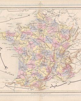
France: فرانسه
- 120.00€
- A map of France from the first Ottoman lithographed atlas. Colour Lithography, 32 x 43 cm (12.6 x 17 inches), (soft fold slightly age-toned, minor wear to the margins, but overall in a good condition).
- Add to cart
-
- Maps and Prints, New Acquisitions: September 2020, Turkey
GALLIPOLI / TURKEY: چناق قلعه بوغاز [Çanakkale Boğazı / Dardanelles]
- 120.00€
- Chromolithographs on thick paper. Each sheet: 11 x 15 cm (4.3 x 5.9 inches). Slightly stained, overall in a good condition
- Add to cart
-
- Maps and Prints, New Acquisitions: September 2020, Turkey
GALLIPOLI CAMPAIGN – BATTLES OF KRITHIA (ALÇITEPE): [Untitled Ottoman Mimeographed WWI Military Map of the Southern Part of the Gallipoli Peninsula].
- 420.00€
- A rare ephemeral artefact from the Gallipoli Campaign of World War I, being a mimeographed map made in the field by Ottoman soldiers, depicting the theatre of the Battles of Krithia (Alçitepe), a series of four major altercations fought between British Imperial-French forces and the Turks between April and August 1915. Mimeograph in purple (Very Good, old vertical centrefold,…
- Add to cart
-
- Croatia, Maps and Prints
GEOLOGICAL MAP / CROATIA / YUGOSLAVIA: Geološka karta srednje in spodnje Istre s sosednjimi otoki [Geological Map of Middle and Lower Istria with the Neighbouring Islands].
- 380.00€
- A large, seemingly unrecorded geological wall map of South Istria and Northern Dalmatian Islands with manuscript colouring was made after WWII, when the territory was regained by Yugoslavia after more than two decades under Fascist Italian government.
- Add to cart
-
- Europe, Maps and Prints, Turkey
Gigantic Wall Map of Istanbul
- 2,800.00€
- Circa 185 x 130 cm (72 x 50 inches), lithograph in colour, printed from two originally joined plates, originally mounted on linen with wooden rollers. With contemporary annotations in pencil and pen. A rare gigantic wall map of Fatih in the European Part of Istanbul is the first official survey project of the city, made in the newly…
- Add to cart
-
- Austria, Europe, Maps and Prints, New Acquisitions: September 2020
GRAZ: Plan der Provinzial Hauptstadt Graz im Herzogthume Steyermark
- 450.00€
- Lithograph printed on two joined sheets 58 x 69 cm (22.8 x 27.2 inches) (minor staining, tiny tears in the margins, overall in a good condition).
- Add to cart
-
- Europe, Greece, Maps and Prints
GREECE: ΝΕΟΣ ΠΟΛΙΤΙΚΟΣ ΧΑΡΤΗΣ ΤΕΣ ΕΛΛΑΔΟΣ ΥΠΟ Δ. ΔΗΜΗΤΡΑΚΟΥ
- 440.00€
- [New Political Map of Greece under D. Dimitrakos] [Neos politikos khartis tes Ellados ipo D. Dimitraki] Colour lithograph, 100 x 70 cm (39.4 x 27.6 inches) (soft folds, tiny tears in margins, otherwise in a good condition).
- Add to cart
-
- Europe, Germany, Maps and Prints
HAMBURG
- 6,500.00€
- Add to cart
-
- Europe, Hungary, Maps and Prints
Hungary / Railroad Map: Magyarország vasuti térképe. Ungarns Eisenbahnkarte [Railroad Map of Hungary]
- 380.00€
- Colour lithograph, 64 x 94 cm (25. 2 x 37 inches), originally dissected in 16 segments and mounted on linen (minor staining, overall in a good clean condition).
- Add to cart
-
- Europe, Hungary, Maps and Prints
HUNGARY WORLD WAR II: Schwäbische Türkei: Gebiete Tolnau, Baranya, Schomodei.
- 750.00€
- A very rare and intriguing ethnographic map showcasing ‘Schwäbische Türkei’ (Swabian Turkey), the region of southwestern Hungary that since the late 17th century had been home to a large enclave of German Settlers (‘Donauschwaben’), who were imported to the region by the Austrian Habsburgs to revive the agrarian economy in the wake of the eviction of the Ottomans; the ‘Donauschwaben…
- Add to cart
-
- Bindings, Books, Europe, Portugal, Spain
IBERIA – SPAIN & PORTUGAL / FINE BINDING: A New Map of Spain and Portugal, Exhibiting the Chains of Mountains with their Passes, the Principal & Cross Roads, with Other Details requisite for the Intelligence of Military Operations compiled by Jasper Nantiat.
- 3,000.00€
- Jasper NANTIAT (d. 1817), Cartographer; William FADEN (1749 – 1836), Publisher. London: William Faden, January 1, 1810. Copper engraving with full original hand colour, dissected and mounted on 4 parts of original linen, all housed in an exquisite custom-made full brown calf box (measuring 23 x 16.5 x 4.5 cm), dating from 1811-5, with elegant gilt tooling and a black…
- Add to cart
-
- Europe, Maps and Prints, Turkey
Istanbul
- 180.00€
- Colour lithograph, printed from both sides, 49 x 69 cm (27.1 x 19.3 inches) (soft folds, but otherwise in a good condition).
- Add to cart
-
- Europe, Maps and Prints, Turkey
Istanbul, Fatih
- 4,500.00€
- Anon. Istanbul, Fatih [S. l., S. d., but Istanbul: between 1923-1928]. Black ink and water-colours in blue, orange, green and red on tracing paper, irregular format, but at widest points 142 x 160 cm (55.9 x 63 inches), originally dissected in segments and mounted on linen (minor tears and folds to the edges of segments, but overall in a good…
- Add to cart
-
- Maps and Prints, Turkey
ISTANBUL: Nouveau plan de Constantinople et des environs
- 4,200.00€
- A rare chromolithographed plan of Istanbul with charming wrappers, printed in Zürich and published by a German book shop in Istanbul. Chromolithographed map, originally dissected in 15 segments and mounted on paper, 63 x 73 cm (24.8 x 28.7 inches), folded in original illustrated cromolithographed wrappers 8° (Slightly age-toned, minor chips to the edges of segments, sporadic annotations…
- Add to cart
-
- Maps and Prints, Turkey
IZMIR, TURKEY: Coastline and inshore soundings west of Sas Burnu from Turkish Governmant Charts of 1941
- 150.00€
- Lithograph with a pasted down instructions and manuscript annotations in pencil and pink colour, 70 x 102 cm (27.6 x 40.1 inches) (Very Good, soft folds).
- Add to cart
-
- Europe, New Acquisitions: October 2020
LAUSANNE, SWITZERLAND CITY MAP – PANORAMA: Plan monumental de Lausanne. Légende des principales curiosités, artères , places et promenades. Panorama du signal.
- 220.00€
- Colour lithograph, 70 x 51 cm (27.6 x 20 inches), verso views and advertisements (soft folds with small partly repaired holes on the crossings and tears in margins, minor staining, otherwise in a good condition).
- Add to cart
-
- Maps and Prints, Russia, Slavica, World Maps
Mapping Lenin’s Work: Kарта составлена и подготовлена к печати Научно-редакционной картосоставительской частью ГУГK при участии научных сотрудников Института марксизма-ленинизма при ЦK Kпcс. Редакторы: Е.В. Гладкова, Г.В. Шадрина Научные консультанты: Г.Н. Голиков, Д.С. Kислик, 3.А. Лёвина, Н.П. Мамай, Т.В. Панченко, Р.М. Савицкая
- 2,200.00€
- [The map was compiled and prepared for printing by the Scientific and Editorial Mapping Department of the Federal Agency for Geodesy and Cartography with the participation of researchers from the Institute of Marxism-Leninism at the Central Scientific Research Center of the Central Committee of the Communist Party of the Soviet Union. Editors: E.V. Gladkova, G.V. Shadrina Scientific advisers: G.N. Golikov,…
- Add to cart
-
- Europe, Greece, Maps and Prints
MILOS / GREECE: Milo insula posta nel mare dello Arcipelago longi dalla Morea…
- 500.00€
- Camocio’s separately issued map of the Greek island Milos with handsome old colouring Originally coloured copper engraving, 20 x 14,5 cm, mounting paper: 21,5 x 19 cm (minor staining, a tiny repaired tear in the white margin, but overall in a good condition).
- Add to cart
-
- Europe, Maps and Prints, Turkey
Moltke’s Map of the Bosporus: Karte des nördlichen befestigten Theils des Bosphorus von den Hissaren bis zu den Leuchtthürmen am Schwarzen Meer im Auftrage Sr. Hoheit Sultan Mahmud II. Mit dem Messtisch in 1 : 25,000 aufgennommen 1836-37 durch Freiherrn von Moltke.
- 3,800.00€
- A rare map of the Bosporus commissioned by Ottoman Sultan Mahmud II and created by Prussian military surveyor Helmuth von Moltke. Lithography with original colour in outline, 73,5 x 68 cm (29 x 26,77 inches), dissected in 20 segments and mounted on linen. An advertisement of Artaria, Vienna, on green paper mounted on one of the segments verso. Housed…
- Add to cart
-
- Europe
OPERATION BARBAROSSA / WORLD WAR II: 圖要ソ・獨ふ闘 [Soviet Union and Its Sole Fight]
- 850.00€
- An ephemeral Japanese map illustrating Operation Barbarossa in September 1941 highlights the complex relations between Japan, the Soviet Union, and the Axis powers during World War II. Colour lithography, 53 x 75 cm (21 x 29.8 inches) (soft folds).
- Add to cart
-
- Czech Republic, Europe, Photography
ORIENATLISM IN PRAGUE: Linguistische Verein in Prag [Linguistic Society in Prague]
- 550.00€
- A photograph of today little known Prague-based Linguistic Society, joining the prominent Austro-Hungarian researchers of Africa, as well as Indian, Arabic and Classical languages. Gelatin silver photo, contemporary mounted on thick card, manuscript numbers recto in margin, black manuscript in black ink and pencil on the back, 12 x 16,5 cm (4.7 x 6.5 inches), (minor foxing verso,…
- Add to cart
-
- Europe, Greece, Maps and Prints, Turkey
Ottoman Cartography / Rumelia: روم ايلى شهانه خريطه سى [Rumeli-yi şahane haritası also Rumeli-i şahane haritası / Map of Principality Rumelia]
- 1,400.00€
- A gigantic (over 2 m) wall map of Rumelia (Northern Greece) made by the Ottoman Military Office Colour lithography, composed of 12 plates, originally mounted on linen and varnished, with original wooden rollers, 124 x 210 cm (48.8 x 82.7 inches) (minor staining and water-staining, light scratches, small losses of image in the middle part, rollers with chipping…
- Add to cart
-
- Europe, Maps and Prints, Turkey
Ottoman Cartography: استانبول بوغازى و جواري خريطه سى [İstanbul Boğazı ve civarı haritası / Map of the Bosporus and Its Surroundings]
- 1,200.00€
- A large separately published detailed map of Istanbul and the Bosporus, with their contemporary infrastructure and urbanism as developed by 1911, published by the Ottoman state press Colour lithography, 100 x 108 cm (39.4 x 42.5 inches), originally dissected in 24 segments and mounted on linen (good, used example, slightly age-toned, stained and with small ink-staining, linen with…
- Add to cart
-
- Europe, France, Maps and Prints, Ottoman Books, September 2023: 50 under 1000 EUR, Turkey, Turkica
OTTOMAN CARTOGRAPHY: بلفور Belfort
- 450.00€
- Photolithography, originally dissected in 8 segments and mounted on linen 74 x 103 cm (29.2 x 40.6 inches), (minor staining, sporadic annotations in pencil in Ottoman in margins, but overall in a good, use condition).
- Add to cart
-
- Maps and Prints, Turkey
Ottoman Geological Map: اناطولى علم ارض خريطه سى [Geological Map of Anatolia].
- 1,400.00€
- Rare and Important – the first proper geological map of Turkey; a large, separately published work created by the professors Damat Kenan and Ahmet Malik Sayar, issued by the imperial printer in 1920 during the twilight of the Ottoman Empire, forming the foundation for scientific and commercial discovery during the upcoming Turkish Republican Era; printed in Ottoman Turkish text with…
- Add to cart
-
- Balkans, Books, Bulgaria, Croatia, Europe, History, Hungary, Maps and Prints
OTTOMAN MILITARY ATLAS: محاربات مشهوره عثمانه البومى
- 3,500.00€
- [Muharebat-ı meşhure-i osmaniye albümü / Album of Famous Ottoman Battles] A monumental portfolio of the famous Ottoman battles, edited by a famous military leader Ahmed Muhtar Pacha during WWI to commemorate the glorious military past of the Ottoman Empire Folio. Title page, 33 unbound double page maps, partly printed in colours, with text, 5 single page maps,…
- Add to cart
-
- Balkans, Europe, Maps and Prints
Ottoman Mss. / Telegraph Map – Greece / North Macedonia / Albania: [No Title – Map of the Telegraph System in the Vilayets of Salonica, Monastir, Janina and Scutari].
- 1,800.00€
- A stellar, large format, original manuscript map of the telegraph system in the Ottoman Balkans, specifically in modern Greece, Northern Macedonia and Albania; with text entirely in Ottoman Turkish, it was drafted in 1889 seemingly as working document by the governmental administration that managed the empire’s telegraph network – an extraordinary survivor documenting a critical medium that revolutionized society during…
- Add to cart
-
- Arabic Books, Books, Maps and Prints, Middle East, Ottoman Books, Turkey, Turkica
Ottoman Thematic Cartography: داخليه نظارتى امور محليه ولايات مدیریتى ولايات يوللرى خريطه سى
- 9,500.00€
- Exceedingly rare – one of the great monuments of Late Ottoman cartography, being the only official large-format Ottoman transportation atlas, including 26 double-page maps of an original, ingenious proto-modernist design, of which 8 maps concern the Arab World, including 1 map showcasing Hejaz and 1 map depicting Mecca & Jeddah; backed by detailed text explaining numerous itineraries for the…
- Add to cart
-
- Czech Republic, Europe, Maps and Prints
Pan-Slavism / Prague: Upomínka na Národopisnou výstavu českoslovanskou v Praze 1895
- 1,400.00€
- [Souvenir of the Czechoslavic Ethnographic Exhibition in Prague 1895] Folding paper fan with a chromolithographed view on the front and poem on the back, mounted on wooden sticks, joined with a metal loop at the bottom, 35 x 64 cm (13.8 x 25.2 inches) (Very Good, with only minor wear to the folds).
- Add to cart
-
- Africa, Maps and Prints, Spain
PEÑÓN DE ALHUCEMAS, Spain / Morocco: Alhuzemas
- 750.00€
- A 1778 manuscript map of the Spanish fortification Peñón de Alhucemas, off the Moroccan coast, was made by a North German officer and engineer Philip Ernst Colson.
- Add to cart
-
- Europe, Greece, Maps and Prints
Piraeus, Greece / Urban Planning: Πειραιευσ και Συνοικισμοι…1:8.000. [Piraeus and its Neighbourhoods].
- 950.00€
- A rare master plan of Piraeus, the port of Athens, made during the Roaring ‘20s when the city was undergoing a dramatic transformation towards becoming one of the world’s great commercial and a passenger ports, detailing every block, major building and site, as well as outlining the new neighbourhoods that were in the process of being developed north of the…
- Add to cart
-
- Europe, Maps and Prints, Poland
POLAND: Odwiedzajcie uzdrowiska dolnośląskie [Visit Lower Silesian Health Resorts]
- 650.00€
- Colour Lihograph 65 x 87 cm (25.6 x 34.2 inches), verso German map from 1941. (Soft folds, small partly repaired tears, tiny loss of paper in margins, slightly dusty.
- Add to cart
-
- Europe, Maps and Prints, Poland
POLISH 20TH CENTURY CARTOGRAPHY: Krakowsko-śląski okręg turystyczny. Rayon touristique des districts de Cracovie et de la Silésie Polonaise.
- 420.00€
- Colour lithograph, folded in original paper wrappers with lettering, 41 x 64 cm (16.1 x 25.2 inches) (soft folds, otherwise in a good condition).
- Add to cart
-
- Austria, Europe, Maps and Prints
Portrait of Friedrich von GENTZ (1764-1832).
- 7,500.00€
- Of great historical importance – the earliest known portrait of Friedrich von Gentz, one of the central figures of the Vienna Conference of 1814-1815.
- Add to cart
-
- Europe, Germany, Maps and Prints, New Acquisitions: October 2020
POST-WWII GERMAN CARTOGRAPHY: Der Wegweiser von und nach der Lutherstadt Wittenberg [The Road Map to and from Lutherstadt Wittenberg]
- 320.00€
- A beautifully designed, optically effective road map to the protestant cultural center Wittenberg in Eastern Germany under the Soviet occupation was made in 1946, immediately after WWII in destroyed Berlin, and printed on the leftovers of an older larger map. Colour lithograph, printed from both sides, original label mounted on the back, 86 x 69 cm (33.9 x 27…
- Add to cart
-
- Austria, Czech Republic, Europe, Maps and Prints
Prospekt des böhmischen Volksfestes, welches die böhmischen Herren Stände zur Zeit der Krönungsfeier S. M. des Kaisers und Königs Ferdinand I. und S. M. der Kaiserin und Königin Maria Anna nächst dem Prager Invalidenhause veranstaltet haben. (14. September 1836)
- 2,600.00€
- An exceedingly rare depiction of a Prague folk festival for the Coronation of Emperor Ferdinand I and Maria Anna of Savoy, lithographed in Litoměřice, showcases unique ethnographic and documentary details from this historic event as well as the diversity of Bohemian culture and social life of the early 19th century in Prague. Lithograph, 55 x 69 cm (21.6 x…
- Add to cart
-
- Europe, Maps and Prints
RAILROADS / DATA VISUALIZATION: Railroad Map of Europe
- 1,700.00€
- A unique, large attractive and modernly architected mid 19th century map in French language, represents modern railroad system as well as geographic and political features of Europe, relevant for railway construction. Manuscript in gouache and black ink on two thick originally joined sheets, 104 x 118 cm (40.1 x 46.5 inches), (repaired tears and tiny losses of image…
- Add to cart
-
- Czech Republic, Europe, Maps and Prints, New Acquisitions: October 2020
RAISED RELIEF MAP – PRAGUE (CZECH REPUBLIC): Die Umgegend von Prag in plastischer Aufnahme von Prof. A.L. Hickmann, k.k. Bezirks-Schulinspector.
- 680.00€
- An extremely rare and intriguing raised relief map of Prague and its environs, created by the innovative professor, Anton Hickmann, whose passion was popularizing geography; published in Reichenberg, in northern Bohemia (today Liberec, Czech Republic). Lithograph in colour, pressed into raised relief on thick card (Good, even toning and some wear to highest points of relief, edges worn and…
- Add to cart
-
- Europe, Greece, Maps and Prints
RHODES / FASCIST ARCHITECTURE: Rodi. Rhodes. Rhodos.
- 750.00€
- A highly decorative pictorial map of Rhodes, representing the newly built Fascist urban structures, was printed by the Italian State Tourist Department. Colour lithography, 69 x 49 cm (27.1 x 19.3 inches) verso black and white illustrations and text (soft folds, overall in a good condition).
- Add to cart
-
- Books, Europe, Geography, Greece, History, Maps and Prints
Rhodes / Sovereign Military Order of Malta: ردوس تاريخى [Rodos Tarihi / The history of Rhodes]
- 1,400.00€
- A rare pioneering Ottoman work on the history of Rhodes before the Muslim Ottoman rule. Printed in Rhodes. 8°, 160 pp. with black and white illustrations, [1] full page black and white map, later black cloth binding with debossed ornaments and gilt lettering (tiny tears in margins, softs fold, map with small loss of paper in the margins,…
- Add to cart
-
- Europe, Italy, Maps and Prints, September 2023: 50 under 1000 EUR
ROME / GAME OF THE GOOSE: Giuoco del Pellegrino. Ricordo di Roma 1950
- 180.00€
- Pilgrim's Game. Memory of Rome 1950. Colour lithograph on thick paper, 61 x 81 cm (24 x 31.9 inches) (soft folds and light foxing, but otherwise in a good condition).
- Add to cart
-
- Europe, Italy, Maps and Prints, New Acquisitions: October 2020
ROUND PANORAMA – MILAN: Panorama orografico e pittoresco della città e contorni di Milano. Preso dalla sommità della cattedrale
- 420.00€
- A round view from the Milan Cathedral from circa 1880 Lithograph (Very Good, overall clean and bright, just some short tears entering from margins closed from verso, old folds), 43.5 x 43.5 (17 x 17 inches)
- Add to cart
-
- Belgium, Europe, Maps and Prints
ROUND PANORAMA / BATTLE OF WATERLOO: Beschrijving van den roemrijken veldslag van Waterloo, voorgesteld in het panorama op het Leidsche Plein over den Hollandschen Schouwburg
- 950.00€
- A pamphlet, explaining a round panorama of the Battle of Waterloo, which was exhibited in a wooden pavilion in Amsterdam. 8°, 1 pp., folding map (40 x 29 cm / 15.7 x 11.4 inches), [8 pp.] text, interleaved sheet with manuscript in brown ink recto, original card boards with illustrations on yellow paper, modern bookplate “Ex Libris van…
- Add to cart
-
- Europe, Maps and Prints, Russia
Russia – World War II: “Kursk” / Курск.
- 650.00€
- An exceedingly rare – possibly unique – artifact from the World War II Nazi German invasion of the Soviet Union, being a indigo photographic print of a Red Army map of Kursk, Russia, made on a portable printing press by one of the German Army’s ‘Motorized Surveying and Map Detachments’; Kursk, occupied by the Germans from November 1941 to…
- Add to cart
-
- Europe, Maps and Prints, Russia
RUSSIA / ‘MODERNIST’ RAILWAY MAP: Схема Желѣзныхъ Дорогъ Европейской Россіи изданіе И. Ф. Зауэра 1914 года.
- 2,200.00€
- [Diagram of Railways in European Russia published by I.F. Zauer 1914]. An extremely rare large format map depicting the railway system in European Russia as its existed on the eve of World War I, executed in an arrestingly Modernist style some years ahead of its time, drafted by the architect Ivan Fedorovich Zauer and published in St. Petersburg…
- Add to cart
-
- Europe, Maps and Prints, Russia
RUSSIAN EMPIRE IN EUROPE – FIRST SCIENTIFIC GEOLOGICAL MAP: Геологическая Kарта Европейской Россіи изданная Геологическимъ Комитетомъ 1892. = Carte géologique de la Russie d’Europe éditée par le comité géologique 1892.
- 3,500.00€
- Alexander Petrovich KARPINSKY [Александр Петрович КАРПИНСКИЙ] (1847 - 1936). / Sergei Nikolaevich NIKITIN (1851 - 1909). / Feodosy Nikolayevich CHERNYSHEV (1856 - 1914). / Nikolai Alekseevich SOKOLOV (1856 - 1907). / Aleksander MICHALSKI (1855 - 1904) et al. St. Peterburg: A. Ilyin’s Cartographic Establishment, 1892. Colour lithograph printed on 6 sheets but here joined and mounted upon mid-20th century linen,…
- Add to cart
-
- Europe, Maps and Prints, Russia
RUSSIAN EMPIRE: Карта Европейской Россіи 1866. / Карта Азіятской Россіи Россійско-Американскихъ Владѣнй.
- 650.00€
- A very rare and decorative folding map of the Russian Empire, providing a fine overview of the growing railway system in European Russia and imperial expansion in the Far East, printed in Russian Cyrillic, and issued by a boutique printer in St. Petersburg.
- Add to cart
-
- Balkans, Bosnia, Europe, Maps and Prints
SARAJEVO: Walny’s Plan von Sarajevo und Umgebung [Walny’s Map of Sarajevo and Surroundings]
- 650.00€
- A detailed map of fin de siècle Sarajevo Colour lithography, 55 x 75 cm (inches) (soft folds with repaired small tears, minor age-toning, but overall in a good condition).
- Add to cart
-
- Balkans, Europe, Maps and Prints, New Acquisitions: December 2020, Serbia
SERBIA
- 120.00€
- A map from Umûm Vilayât-ı Şâhâneyi Hâvi Küçük Atlas - Umûmî Küçük Atlas (General Small Atlas) Chromolithograph. 9 x 13,5 cm (3.5 x 5.3 inches).
- Add to cart
-
- Albania, Balkans, Europe, Maps and Prints
SHKODËR COUNTY, NORTHERN ALBANIA OTTOMAN CARTOGRAPHY / SIEGE OF SHKODËR
- 2,200.00€
- [The view of the Hut Hills, where the 3rd Regiment, which was dispatched from Istanbul, which was in charge of protecting the city from the attack of the rebels, defended for 45 days until the force needed in Iskodra was replenished] [and:] [Headquarters of the 2nd Division of the Ishkodra Forces. The Rrapshë Plain] Unique late Ottoman bird’s…
- Add to cart
-
- Austria, Balkans, Croatia, Europe, Hungary, Maps and Prints, Slovenia
THE BALKANS, AUSTRIA AND EASTERN GERMANY: Quinta Europe Tabula.
- 5,500.00€
- The rare map of the Balkans, Austria and Southern Germany from the ‘Rome Ptolemy’, a monument in the early history of engraving and the cartography of Central and Southeastern Europe.
- Add to cart
-
- Europe, Greece, Maps and Prints, September 2023: 50 under 1000 EUR
Thessaloniki: ΘΕΣΣΑΛΟΝΙΚΗ
- 150.00€
- Lithograph, 57 x 84 cm (22.4 x 33 inches) (soft folds with tiny tears, but overall in a good condition).
- Add to cart
-
- Europe, Maps and Prints, South America, Turkey
Turkey in Asia
- 150.00€
- Steel engraved playing card, overlaid in coloured stencil, blank on verso (Very Good, minor stainng verso, a small scratch and stain on the front), 97 x 65 mm (3.8 x 2.6 inches).
- Add to cart
-
- Europe, Malta, Maps and Prints
VALETTA, MALTA: Plan of the Harbours and Fortifications of Valetta In the Island of Malta By Captain W. H. Smith, R.N. Knight of St. Ferdinand and Merit.
- 550.00€
- Copper engraving, 50 x 67 cm (inches) (minor age-toning and staining, old stamps and inventory numbers and a stamp Erledigt (meaning ‘Deaccessioned’).
- Add to cart
-
- Europe, Maps and Prints, Russia
VYBORG (Выборг / VIIPURI), RUSSIA: [Proof State – Carte du Golfe de Wibourg à la Côte de Karèlie].
- 1,500.00€
- A proof state of an exceptionally rare sea chart of Vyborg Harbour, Russia, prepared for Charles-Pierre Fleurieu’s grand atlas of the Baltic Sea.
- Add to cart
-
- Europe, Maps and Prints, Portugal
Wine Map of Porto, Portugal: Visitez les Chais de vin de Porto de Porto Cintra. Warre Ca. Lda.
- 120.00€
- Colour lithograph, printed from both sides, 46 x 62 cm (24.4 x 18.1 inches) (soft folds, but otherwise in a good condition).
- Add to cart
-
- Books, Maps and Prints, Turkey
WWI / GALLIPOLI CAMPAIGN / CAPE HELLES SECTOR / ORIGINAL MANUSCRIPT / FIELD ANNOTATIONS / LAWRENCE OF ARABIA: Map of Southern Gallipoli from a Captured Turkish Map.
- 4,500.00€
- A spectacular artefact of the Gallipoli Campaign, being an extremely rare ultra large map of the Cape Hellas-Krithia battle sector issued by T.E. Lawrence’s (later ‘Lawrence of Arabia’) map department at the Intelligence Office in Cairo, predicated upon a recently “captured” Ottoman map that was the first proper survey of this critical military zone; greatly augmented by extensive and…
- Add to cart
-
- Africa, Europe, Maps and Prints, New Acquisitions: November 2020
WWII IN NORTH AFRICA / SICILY / D-DAY / FRANCE / GERMANY / SOLDIERS’ ITINERARY CARTOGRAPHY: The Route of The Ninth Division Thru the Natousa & Etousa Nov. 8, 1942 – June 1945.
- 650.00€
- A fascinating itinerary map of the route of the U.S. Army’s Ninth Infantry Division during their World War II active combat tours, featuring their routes in North Africa, Sicily, England, France (including the D-Day Landings) and Germany; published in Germany only 2 months after the end of the war as a memento for the troops – notably, one of only…
- Add to cart
-
- Europe, Maps and Prints, New Acquisitions: October 2020, Portugal
WWII POLAND – ŁÓDŹ / HOLOCAUST: Plan der Stadt Lodsch.
- 850.00€
- A deeply disturbing but historically important map depicting Łódź, Poland shortly after it was conquered by the Nazis in early World War II; all the of place and street names have been changed from Polish to German nomenclature and all signs of the city’s Polish population and Jewish community (which numbered over 30% of the city’s residents) has been erased;…
- Add to cart
-
- Africa, Balkans, Europe, Greece, Maps and Prints, Middle East, Turkey
عمومه ممالك عثمانيه [General Ottoman Empire]
- 220.00€
- Map of the Ottoman Empire with the Arabian Peninsula in the middle. Marked are the most important cities and the Hejaz Railway. Colour lithography, 26 x 38 cm (10.2 x 14.9 inches), (soft fold in the middle slightly stained with tiny repaired holes and tears).
- Add to cart

![2 Raised-Relief Maps – GORIZIA / FRIAUL / ITALY / SLOVENIA: Gorizia. [and:] Contea Principesca di Gorizia e Gradisca](https://pahor.at/wp-content/uploads/2024/03/gg-265x331.jpg)

![ALBANIA & MONTENEGRO: ِاشقودره ولآيت [İşkodra Vilayet / Scutari Vilayet].](https://pahor.at/wp-content/uploads/2020/06/65982-265x331.jpg)
![ALEPPO, SYRIA & TURKEY: حلب ولآيت [HALEP VILAYET / ALEPPO VILAYET].](https://pahor.at/wp-content/uploads/2020/06/65983-265x331.jpg)

![ARABIAN PENINSULA / OTTOMAN EMPIRE: اسياى غرب [West Asia]](https://pahor.at/wp-content/uploads/2022/02/2022-02-05_144645-copy-265x331.jpg)
![ARMENIA: Армянская ССР. Экономическая учебная карта [Armenian SSR. School Map of Economy]](https://pahor.at/wp-content/uploads/2022/10/69870-265x331.jpg)

![ATATÜRK / TURKISH REPUBLICANISM: انا وطن [Ana Vatan / Homeland].](https://pahor.at/wp-content/uploads/2024/03/Febreiro20-copy-265x331.jpg)
![Azerbaijan SSR: Azerbajcanın sijasi va təbii Xərıtəsi [Political and Natural Map of Azerbaijan]](https://pahor.at/wp-content/uploads/2022/06/IMG_8802-Recovered-265x331.jpg)
![BATTLE OF ZORNDORF (1758): Карта положение медь между Город б. ландсберхомъ. [Map of the position between the city of Landsberg…]](https://pahor.at/wp-content/uploads/2023/03/Zorndorf-265x331.jpg)


![Bezengi, Russia & Georgia: Skupina Bezengi [Bezengi Group].](https://pahor.at/wp-content/uploads/2020/06/65859-265x331.jpg)
![BITOLA -MANASTIR / NORTH MACEDONIA / OTTOMAN CARTOGRAPHY / POSTCARD MAP: مناستر ولآيتى [Vilayet Manastir]](https://pahor.at/wp-content/uploads/2020/08/68976-1-265x331.jpg)


![CROATIAN ART-DECO MAP: Putovanja „Jutranjeg lista“ [Travels of „Jutranji list“].](https://pahor.at/wp-content/uploads/2020/06/66279-265x331.jpg)
![CYPRUS / OTTOMAN CARTOGRAPHY: قبريس آطه سى [Kıbrıs Ada-sı / Island Cyprus]](https://pahor.at/wp-content/uploads/2020/09/2020-09-04_234428-265x331.jpg)
![DANUBE RIVER – BOAT CAPTAIN’S ATLAS: Navigations Karte Der Donau von Semlin an bis zu ihrem Ausfluss ins Schwarze Meer : zur genauesten Kentnis aller in derselben befindlichen Inseln, Sandbänke, Wirbel, Klippen u.s.w. so wie aller an den beiderseitigen Ufern gelegenen Städte, Dörfer und andere Ortschaften, wobei zugleich die verschiedene Breite und Tiefe des Stroms bestimt angegeben ist, zuerst aufgenomm[m]en von dem k.k. Pontonier Hauptmann von Lauterer, da derselbe den k.k. Herrn Internunzius Freyherrn von Herbert bis Ruszug führte, hierauf aber weiter ausgearbeitet und verbessert von dem k.k. Hauptmann Freyherrn von Tauferer bei Gelegenheit, als derselbe das erste Seeschiff aus der Kulpa auf der Donau nach Konstantinopel führete.](https://pahor.at/wp-content/uploads/2021/11/IMG_1346-copy-265x331.jpg)
![DEMOGRAPHIC MAP OF LITHUANIA: Mapa narodowościowa i polityczna obszarów b. W. Ks. litewskiego z tablicą statystyczną [Title on the Cover]](https://pahor.at/wp-content/uploads/2023/06/Javajoe36-copy-265x331.jpg)
![DENMARK, ICELAND: Map of Denmark [Title on the Cover]. Denmark, Schleswig, Holstein.](https://pahor.at/wp-content/uploads/2023/08/70278-265x331.jpg)
![DISTANCE-TIME-ROUTE MAP / OTTOMAN EMPIRE: ممالك محروسه شاهانه [Imperial Guarded Domain…]](https://pahor.at/wp-content/uploads/2023/04/Javajoe43-copy-265x331.jpg)

![FIRST SOVIET HISTORICAL ATLAS / POLITICAL PROPAGANDA: Русский исторический Атлас [Russkiĭ istoricheskiĭ atlas / Russian Historical Atlas]](https://pahor.at/wp-content/uploads/2023/01/IMG_4590-1-copy-265x331.jpg)
![GALLIPOLI / TURKEY: چناق قلعه بوغاز [Çanakkale Boğazı / Dardanelles]](https://pahor.at/wp-content/uploads/2020/08/68977-1-265x331.jpg)
![GALLIPOLI CAMPAIGN – BATTLES OF KRITHIA (ALÇITEPE): [Untitled Ottoman Mimeographed WWI Military Map of the Southern Part of the Gallipoli Peninsula].](https://pahor.at/wp-content/uploads/2020/09/gali-265x331.jpg)
![GEOLOGICAL MAP / CROATIA / YUGOSLAVIA: Geološka karta srednje in spodnje Istre s sosednjimi otoki [Geological Map of Middle and Lower Istria with the Neighbouring Islands].](https://pahor.at/wp-content/uploads/2020/06/68193-265x331.jpg)


![Hungary / Railroad Map: Magyarország vasuti térképe. Ungarns Eisenbahnkarte [Railroad Map of Hungary]](https://pahor.at/wp-content/uploads/2021/04/scan57a-265x331.jpg)

![HUNGARY, CROATIA, SERBIA & BOSNIA: [Novissima et Accuratissima Hungariae cum circumjacentibus Regnis et Principatibus]](https://pahor.at/wp-content/uploads/2020/06/63089-265x331.jpg)


![LENINGRAD (St. Petersburg), Russia: Ленинград спутник туриста [Tourist guide of Leningrad].](https://pahor.at/wp-content/uploads/2020/06/64869-265x331.jpg)


![Nezavisna Država Hrvatska. Zeljeznicka mreza i ostali prometni putovi [Independent State of Croatia. Railways and Other Traffic Routes]](https://pahor.at/wp-content/uploads/2020/06/65102-265x331.jpg)
![OPERATION BARBAROSSA / WORLD WAR II: 圖要ソ・獨ふ闘 [Soviet Union and Its Sole Fight]](https://pahor.at/wp-content/uploads/2025/05/Feb25_710-copy-265x331.jpg)
![ORIENATLISM IN PRAGUE: Linguistische Verein in Prag [Linguistic Society in Prague]](https://pahor.at/wp-content/uploads/2023/03/Foto_2023-02-22_233702-265x331.jpg)
![Ottoman Cartography / Rumelia: روم ايلى شهانه خريطه سى [Rumeli-yi şahane haritası also Rumeli-i şahane haritası / Map of Principality Rumelia]](https://pahor.at/wp-content/uploads/2022/06/wall-265x331.jpg)
![Ottoman Cartography: استانبول بوغازى و جواري خريطه سى [İstanbul Boğazı ve civarı haritası / Map of the Bosporus and Its Surroundings]](https://pahor.at/wp-content/uploads/2022/06/Januarmap4538-copy-265x331.jpg)
![Ottoman Geological Map: اناطولى علم ارض خريطه سى [Geological Map of Anatolia].](https://pahor.at/wp-content/uploads/2021/06/69351-265x331.jpg)

![Ottoman Mss. / Telegraph Map – Greece / North Macedonia / Albania: [No Title – Map of the Telegraph System in the Vilayets of Salonica, Monastir, Janina and Scutari].](https://pahor.at/wp-content/uploads/2020/07/alb-265x331.jpg)


![Piraeus, Greece / Urban Planning: Πειραιευσ και Συνοικισμοι…1:8.000. [Piraeus and its Neighbourhoods].](https://pahor.at/wp-content/uploads/2020/07/pir2-265x331.jpg)

![POLAND: Odwiedzajcie uzdrowiska dolnośląskie [Visit Lower Silesian Health Resorts]](https://pahor.at/wp-content/uploads/2023/06/Abrilmap-265x331.jpg)


![POST-WWII GERMAN CARTOGRAPHY: Der Wegweiser von und nach der Lutherstadt Wittenberg [The Road Map to and from Lutherstadt Wittenberg]](https://pahor.at/wp-content/uploads/2020/10/69037-265x331.jpg)


![Rhodes / Sovereign Military Order of Malta: ردوس تاريخى [Rodos Tarihi / The history of Rhodes]](https://pahor.at/wp-content/uploads/2022/05/rho1-265x331.jpg)


![SARAJEVO: Walny’s Plan von Sarajevo und Umgebung [Walny’s Map of Sarajevo and Surroundings]](https://pahor.at/wp-content/uploads/2021/07/69383-265x331.jpg)


![VYBORG (Выборг / VIIPURI), RUSSIA: [Proof State – Carte du Golfe de Wibourg à la Côte de Karèlie].](https://pahor.at/wp-content/uploads/2020/06/62344-265x331.jpg)


![عمومه ممالك عثمانيه [General Ottoman Empire]](https://pahor.at/wp-content/uploads/2021/10/69476-265x331.jpg)