-
- Maps and Prints, Middle East, Turkey
ALEPPO, SYRIA & TURKEY: حلب ولآيت [HALEP VILAYET / ALEPPO VILAYET].
- 200.00€
- A very rare lithographed postcard map of the Aleppo Vilayet in Ottoman script was made in Istanbul during the Young Turks Regime by a Romanian born publisher Tüccarzâde İbrahim Hilmi Çığıraçan.
- Add to cart
-
- Maps and Prints
Alexander von Humboldt in seiner Bibliothek [Alexander von Humboldt in His Library]
- 1,400.00€
- A scarce large representation of the German explorer Alexander von Humboldt in his Berlin library, and surrounded by the artefacts from his journeys in the last years of his life. Colour Lithograph, 70 x 85 cm (27 x 33.3 inches) (minor age-toning, tiny chips in margins, repaired tear in the lower margin).
- Add to cart
-
- Maps and Prints
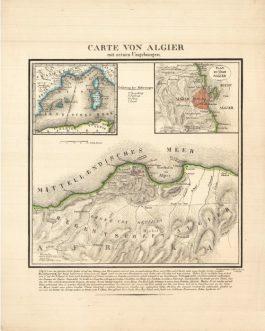
ALGIERS, Algeria: Carte von Algier mit seinen Umgebungen.
- 450.00€
- A rare, seemingly unrecorded lithographed broadside, printed in Switzerland, shows Algiers, besieged by French in 1830.
- Add to cart
-
- Americas, Maps and Prints, New Acquisitions: October 2020
AMERICA – OTTOMAN SCHOOL ATLAS: آمريقا [Amerika]
- 380.00€
- 8°. 29-35 pp., facing pages marked with the same number, with colour lithographed plates, printed covers, stapled (tiny loss of paper in the lower corners of the last pages, light staining and foxing, otherwise in a good used condition).
- Add to cart
-
- Africa, Maps and Prints
ANGOLA – EARLY OIL (PETROLEUM) EXPLORATION: [Set of 2 Cyanotype Maps and 1 Line Chart of 1920s Oil Exploration in Angola].
- 1,800.00€
- A trio of very large format diagrams (2 blueprint maps, 1 line chart) made for the Companhia de Petróleo de Angola in the 1920s, when it was prospecting the Cuanza (Kwanza) Basin, one of Africa’s great petroleum deposits; the works were drafted by James J. McGowan, a larger-than-life Irish-American engineer who later became a pillar of Luanda’s business community; the…
- Add to cart
-
- Europe, Maps and Prints, Turkey
Ankara
- 350.00€
- Colour print, 63 x 46 cm (inches) (soft folds, minor age-toning, but overall in a good condition). A decorative late art deco map showcases Ankara with its modern neighborhoods
- Add to cart
-
- Americas, Caribbean, Maps and Prints
Antigua in the West Indies America. Laid Down by actual Survey, and engraved by John Luffman, in the years 1787 and 1788. / To His Excellency Major General Sir Thomas Shirley Governor Bart. Captain General & Governor in Chief in and over all His Majestys Leeward Caribee Islands, in America. Chancellor, Vice Admiral & Ordinary of the same. This Map is Dedicated, by his obliged humble Servant, John Luffman.
- 9,500.00€
- John Luffman’s grand map of Antigua, one of the cartographic monuments of the 18th century British West Indies; predicated upon the goldsmith-cartographer’s reconnaissance of the island conducted when it was still one of the world’s leading sugar-slave economies, as well as hosting a major Royal Navy base (then commanded by the future Lord Admiral Horatio Nelson); the map served as…
- Add to cart
-
- Americas, Caribbean, Maps and Prints
ANTIGUA, WEST INDIES / SLAVERY & EMANCIPATION: A New & Improved Map of the Island of Antigua, in the West Indies. Constructed and drawn chiefly from original Materials and most Recent Surveys. By J. Johnson.
- 9,500.00€
- J. JOHNSON. London: Smith, Elder & Co., August 1829. Copper engraving and aquatint with full original wash hand colour, dissected into 6 sections and mounted upon original linen (Very Good, resplendent original colours and gorgeous print quality, just some light toning and minor print transference), 73.5 x 82.5 cm (29 x 32.5 inches) (#70644a). Exceedingly rare – one…
- Add to cart
-
- Asia, Europe, Maps and Prints, Middle East, Near East, Turkey
ARABIAN PENINSULA / OTTOMAN EMPIRE: اسياى غرب [West Asia]
- 280.00€
- Lithograph with original colour: 18 x 23 cm (7 x 9 inches) (soft fold, slightly stained in the upper margin).
- Add to cart
-
- Maps and Prints, Middle East, New Acquisitions: September 2020
ARABIAN PENINSULA:جزيرة العرب [Arabian Peninsula]
- 550.00€
- Chromolithograph. 9 x 13,5 cm (3.5 x 5.3 inches). Slightly stained.
- Add to cart

![ALEPPO, SYRIA & TURKEY: حلب ولآيت [HALEP VILAYET / ALEPPO VILAYET].](https://pahor.at/wp-content/uploads/2020/06/65983-265x331.jpg)
![Alexander von Humboldt in seiner Bibliothek [Alexander von Humboldt in His Library]](https://pahor.at/wp-content/uploads/2025/09/Mai25_2-Recovered-265x331.jpg)
![AMERICA – OTTOMAN SCHOOL ATLAS: آمريقا [Amerika]](https://pahor.at/wp-content/uploads/2020/10/69080_2-265x331.jpg)
![ANGOLA – EARLY OIL (PETROLEUM) EXPLORATION: [Set of 2 Cyanotype Maps and 1 Line Chart of 1920s Oil Exploration in Angola].](https://pahor.at/wp-content/uploads/2025/10/June25_45-copy-265x331.jpg)


![ARABIAN PENINSULA / OTTOMAN EMPIRE: اسياى غرب [West Asia]](https://pahor.at/wp-content/uploads/2022/02/2022-02-05_144645-copy-265x331.jpg)
![ARABIAN PENINSULA:جزيرة العرب [Arabian Peninsula]](https://pahor.at/wp-content/uploads/2020/08/68977-6-4-265x331.jpg)