-
- Africa, Africa, Books, Madagscar, Maps and Prints
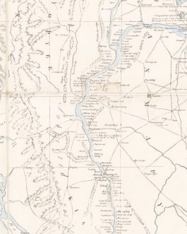
‘Madagascar’ [Atlas Factice of Madagascar]
- 2,600.00€
- administrator or military officer to be employed while making a reconnaissance of the island in the tense period leading up to World War I; featuring 26 colour photolithographed maps and 1 legend sheet all published in Antananarivo by the colonial military press, the ‘Service géographique de l’Etat Major du groupe de l’Afrique Orientale’, including 19 provincial maps and 6 large-format, sophisticated…
- Add to cart
-
- Maps and Prints
[BULGARIA – BORDER PATROL MAP:] Карта на България. Мѣрка 1:800,000. (Разположение на Българскитѣ Погранични Постове.) [Map of Bulgaria. Scale 1:800,000. (Location of the Bulgarian Frontier Posts.)].
- 300.00€
- An extremely rare, large-format separately-issued map of Bulgaria that specifically details the nation’s international boundaries and border patrol infrastructure, printed in 1904 in Sofia for official use, during a tense period leading to major warfare in the region.
- Add to cart
-
- Armenian Books, Maps and Prints, Posters
[ISTANBUL OPERA BROADSIDE / ARMENIAN-OTTOMAN PRINTING:] Teatro Naum in Pera in Costantinopoli / Per la sera di Mercoledì 16 Maggio 1855 / Serata Straordinaria Devoluta a totale Beneficio. Del primo Buffo Comico Assoluto. Vincenzo Galli prima rappresentazi
- 7,700.00€
- An amazing survivor – an early Istanbul opera broadside advertising the 1855 single-show performance of Gaetano Donizetti’s ‘Don Pasquale’ at the famous Naum Theatre in Pera (Beyoğlu), Constantinople, headlined by the legendary basso buffo singer Vincenzo Galli, published locally in Italian, Ottoman Turkish, Greek, Armenian and Armenian printed in the Ottoman Alphabet!
- Add to cart
-
- India, Maps and Prints
[Srinagar] Kashmīr & Jammu. / 1:63.360. / Kashmir North (Bāramūla), Kashmir South (Anantnāg) / No. 43 J16.
- 550.00€
- Srinagar, Kashmir, India / Indian Urbanism / Calcutta Imprint An extremely rare map of Srinagar and environs, the capital of Kashmir and famed as one of the most beautiful places in the world, the map full of intriguing cultural details, published in Calcutta by the Survey of India. Colour heliozincograph (Very Good, clean and bright with attractive colours,…
- Add to cart
-
- Europe, Italy, Maps and Prints, Slovenia
2 Raised-Relief Maps – GORIZIA / FRIAUL / ITALY / SLOVENIA: Gorizia. [and:] Contea Principesca di Gorizia e Gradisca
- 9,500.00€
- Enrico BOMBIG. Gorizia [S. l., but probably area around Gorizia, possibly Farra d’Isonzo]: 1904. Papier-mâché or plaster in relief, with hand-colour, title and names of places in manuscript, 73,5 x 132 cm (29 x 52 inches), with frame 90 x 148 cm (35.4 x 58.3 inches), verso originally stabilized with wooden boards. [And:] Enrico BOMBIG. Contea Principesca di Gorizia e…
- Add to cart
-
- Europe, Maps and Prints, Russia
28 LUBKI: Russia, Cossacks & Ottomans
- 5,500.00€
- A series of 28 Russian lubki showcases the main protagonists of the Caucasian war, battles with the Ottomans, and Cossacks.
- Add to cart
-
- Others
A Concise Introduction to the Study of the Malagasy Language as spoken in Imerina. By W.E. Cousins, missionary of the London Missionary Society. Antananarivo.
- 1,500.00€
- A very rare and important landmark of the study of the Malagasy language and early printing in Madagascar, being a comprehensive grammar of Malagasy made by the Reverend William Edward Cousins, who was one of the leading figures in the 1860s revival of Western and missionary and activity in Madagascar and one of the most prolific authors and connoisseurs of…
- Add to cart
-
- Asia, Maps and Prints, South-East Asia
A Geographical Sketch of the Burmese Empire Compiled at the Office of the Surveyor General of India And published with Permission of Government At the Asiatic Lithographic Press / Calcutta 1825.
- 9,500.00€
- Extremely rare – the foundational modern map of Burma, being the first realistic general map of the country, as well as a monument of early lithography in India; the very large format work was published in Calcutta by the Asiatic Lithographic Press during the height of the First Anglo-Burmese War (1824-6), it served as an invaluable strategic aid for…
- Add to cart
-
- Armenian Books, Maps and Prints
A rare theatre program was issued in French, Ottoman and Armenian in Istanbul circa 1910 for the matinee and evening performance of the Ottoman operetta Leblebici Horhor Ağa in the Orieantal Theater (Şark Theatre) in the Şehzadebaşı neighborhood in Istanb
- 380.00€
- A rare ephemeral program written in French, Armenian and Ottoman, was published for a for the matinée and evening performance of the Ottoman operetta Leblebici Horhor Aga, written by an Armenian author Tigran Tchoukhajian.
- Add to cart
-
- Maps and Prints
A SET OF 8 MINIATURE EMBOSSED (RAISED RELIEF) PORTRAITS ON CARD OF BRITISH LUMINARIES
- 1,000.00€
- A finely executed set of miniature embossed portraits of British luminaries, contained within an interesting envelope, suggesting that the set was posted from India to London in 1891.
- Add to cart
-
- Maps and Prints
ABSINJA I WLOCHY [Abyssinia and Italians].
- 180.00€
- A Polish political broadside showcasing the Italian occupation of the Ethiopian Empire, as a warning to the upcoming situation.
- Add to cart
-
- Maps and Prints, Middle East, Photography
Aden, Yemen
- 1,500.00€
- Four large photographs with German titles depicting Aden in the late 19th century
- Add to cart
-
- Africa, Maps and Prints
AFRICA – SÃO TOMÉ: África Ocidental – Carta da Ilha de S. Tomé. Escala 1/100000, 1922.
- 350.00€
- The first edition of the first map of the island of São Tomé to be predicated upon systematic triangulated surveys, by Gago Coutinho, who subsequently became a world famous aviator, published in Lisbon in 1922.
- Add to cart
-
- Africa, Maps and Prints
AFRICA (NORTH-EASTERN) – EGYPT, LIBYA, SUDAN and TUNISIA
- 380.00€
- A highly attractive separately issued Ottoman map of North-Eastern Africa (Egypt, Libya, Tunisia and Sudan), also embracing adjacent parts of the Middle East and Southern Europe.
- Add to cart
-
- Africa, Books, Geography, History, Maps and Prints, New Acquisitions: November 2020
AFRICA (TANZANIA, CAMEROON, NAMIBIA, TOGO, CONGO) – NAZI DESIGNS IN AFRICA / CARTOGRAPHY / TRANSPORTATION: Straßen im tropischen Afrika: Auszüge aus den Mandatsberichten der Jahre 1922-1937 und aus den Abhandlungen des Kgl. Belgischen Kolonialinstituts 1939.
- 1,200.00€
- An extremely rare Nazi report on the state of roads in Germany's former African colonies and the Belgian Congo, made early in World Wat II in preparation for plans for the Third Reich to regain its African empire either by diplomacy or force, being a printed copy of an original typescript labelled as 'Als Manuskript gedruckt' ('Printed as a manuscript'), issued…
- Add to cart
-
- Africa, Australia, Books, Geography, Maps and Prints, Ottoman Books, South America, Turkica
AFRICA / AUSTRALIA / SOUTH AMERICA / SOUTH POLE: سعدى عبدالقادر لر قطعه آفريقا و آستراليا آمريقا، جنوبى اجاه جوغرافيا عمومى [Umumi coğrafya ile Cenubî Amerika, Avustralya ve Afrika Kıtaları / Basic Geography. Continents South America, Australia and Afr
- 480.00€
- A rare, richly illustrated book in Ottoman script on Africa, North Pole, Australia and South America.
- Add to cart
-
- Africa, Books, Geography, Maps and Prints
AFRICA / BERLIN CONFERENCE (1884-5): Atlas von Afrika. 50 colorirte Karten auf 18 Tafeln. Mit einem geographisch-statistischen text.
- 960.00€
- A scarce, pioneering atlas of Africa with 18 colour plates featuring 50 maps designed by the leading Vienna map house of Freytag & Berndt, including some sophisticated works of thematic cartography and original maps showcasing the level of Western knowledge of the continent, made to capitalize upon the Africa-mania that swept the general public in the wake of the…
- Add to cart
-
- Africa, Books, Geography, Maps and Prints
Africa / Ephemera: آفريقا قطعه سى [The Africa Part]
- 120.00€
- A rare ephemeral Ottoman map of Africa was printed on the back cover of a notebook 8°. [48 pp.] manuscript in pencil on paper with printed stripes, stapled, original pink illustrated wrappers (front cover with light water-staining, tears, loss of image and recently repaired with scotch tape, map with soft folds and tiny tears in the margins, staples…
- Add to cart
-
- Africa, Bindings, Books, Geography, Maps and Prints, Ottoman Books, Turkica
AFRICA TRAVELOUGE: افريقا سياحتنامه سى [Afrika Seyahatnâmesi / Africa Book of Travels, i. e. The Heart of Africa / Im Herzen von Afrika]
- 1,500.00€
- A complete set of the contemporary Ottoman translations of Schweinfurth’s influential travelogue to Africa. 8°: 911 pp. with black and white illustrations, folding map, coloured in outline, one toned lithograph with hand coloured details, contemporary Ottoman black calf with gilt and debossed decoration (remboîtage in a contemporary Ottoman binding) (minor age-toning and foxing, holes in the map on the crossings…
- Add to cart
-
- Africa, Maps and Prints
AFRICA: افريقا قطعه سى [Parts of Africa]
- 200.00€
- Lithograph with original colour: 18 x 23 cm (7 x 9 inches) (soft fold, slightly age-toned and stained).
- Add to cart
-
- Africa, Maps and Prints
AFRICA: يكى افريقا [Yeni Afrika / New Africa].
- 650.00€
- A very rare, large format, separately issued map of Africa that is perhaps the last great map of the continent to be printed in Ottoman Turkish script, with attractive colours and adorned with the flags of major African states and colonies, published in Istanbul for the Kitabhane-yi Sudi bookshop. Colour off-set print (Good, some light staining, wear and some…
- Add to cart
-
- Africa, Maps and Prints
African News Map of Central Africa. With Powell’s Radial Key.
- 1,200.00€
- Colour lithograph, folding into original printed card covers bearing title and view on front cover and a map of the Léopoldville area on back cover (Excellent condition, Map amazingly clean, bright and crisp, seemingly barely ever opened, only the lightest marginal wear to covers), 86 x 68.5 cm (34 x 27 inches). A very rare and early cartographic…
- Add to cart
-
- Maps and Prints
ALASKA – ETHNOGRAPHIC MAP: Ethnographische Skizzen über die Völker des Russischen Amerika. Erste Abteilung: Die Thlinkithen. Die Konjagen. Karte des Russischen Amerika. Nach den neuesten Quellen gezeichnet von H. J. Holmberg. 1854.
- 750.00€
- The first ethnographic map of Alaska, by the Finnish anthropologist H.J. Holmberg, bound within the accompanying Part 1 (of 2 independently-issued parts) of Holmberg’s groundbreaking study of the region.
- Add to cart
-
- Balkans, Maps and Prints
ALBANIA & MONTENEGRO: ِاشقودره ولآيت [İşkodra Vilayet / Scutari Vilayet].
- 250.00€
- A very rare lithographed postcard map of the Scutari Vilayet in Ottoman script was made in Istanbul during the Young Turks Regime by a Romanian born publisher Tüccarzâde İbrahim Hilmi Çığıraçan.
- Add to cart

![‘Madagascar’ [Atlas Factice of Madagascar]](https://pahor.at/wp-content/uploads/2025/11/WhatsApp-Image-2025-11-04-at-18.35.48_6f468957-copy-265x331.jpg)
![[BULGARIA – BORDER PATROL MAP:] Карта на България. Мѣрка 1:800,000. (Разположение на Българскитѣ Погранични Постове.) [Map of Bulgaria. Scale 1:800,000. (Location of the Bulgarian Frontier Posts.)].](https://pahor.at/wp-content/uploads/2020/06/66006-265x331.jpg)
![[ISTANBUL OPERA BROADSIDE / ARMENIAN-OTTOMAN PRINTING:] Teatro Naum in Pera in Costantinopoli / Per la sera di Mercoledì 16 Maggio 1855 / Serata Straordinaria Devoluta a totale Beneficio. Del primo Buffo Comico Assoluto. Vincenzo Galli prima rappresentazi](https://pahor.at/wp-content/uploads/2020/06/66036-265x331.jpg)
![[Srinagar] Kashmīr & Jammu. / 1:63.360. / Kashmir North (Bāramūla), Kashmir South (Anantnāg) / No. 43 J16.](https://pahor.at/wp-content/uploads/2021/05/Aprmap173a-265x331.jpg)
![2 Raised-Relief Maps – GORIZIA / FRIAUL / ITALY / SLOVENIA: Gorizia. [and:] Contea Principesca di Gorizia e Gradisca](https://pahor.at/wp-content/uploads/2024/03/gg-265x331.jpg)


![ABSINJA I WLOCHY [Abyssinia and Italians].](https://pahor.at/wp-content/uploads/2020/06/65055-265x331.jpg)


![Africa / Ephemera: آفريقا قطعه سى [The Africa Part]](https://pahor.at/wp-content/uploads/2020/07/2020-07-04_160724-265x331.jpg)
![AFRICA TRAVELOUGE: افريقا سياحتنامه سى [Afrika Seyahatnâmesi / Africa Book of Travels, i. e. The Heart of Africa / Im Herzen von Afrika]](https://pahor.at/wp-content/uploads/2020/08/binf-265x331.jpg)
![AFRICA: افريقا قطعه سى [Parts of Africa]](https://pahor.at/wp-content/uploads/2022/02/Dokument_2022-02-05_144741-copy-265x331.jpg)
![AFRICA: يكى افريقا [Yeni Afrika / New Africa].](https://pahor.at/wp-content/uploads/2023/03/Febmap2-copy-265x331.jpg)


![ALBANIA & MONTENEGRO: ِاشقودره ولآيت [İşkodra Vilayet / Scutari Vilayet].](https://pahor.at/wp-content/uploads/2020/06/65982-265x331.jpg)