-
- Maps and Prints, Middle East, Turkey
ALEPPO, SYRIA & TURKEY: حلب ولآيت [HALEP VILAYET / ALEPPO VILAYET].
- 200.00€
- A very rare lithographed postcard map of the Aleppo Vilayet in Ottoman script was made in Istanbul during the Young Turks Regime by a Romanian born publisher Tüccarzâde İbrahim Hilmi Çığıraçan.
- Add to cart
-
- Maps and Prints
Alexander von Humboldt in seiner Bibliothek [Alexander von Humboldt in His Library]
- 1,400.00€
- A scarce large representation of the German explorer Alexander von Humboldt in his Berlin library, and surrounded by the artefacts from his journeys in the last years of his life. Colour Lithograph, 70 x 85 cm (27 x 33.3 inches) (minor age-toning, tiny chips in margins, repaired tear in the lower margin).
- Add to cart
-
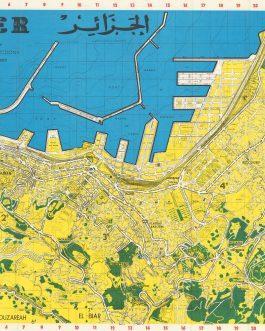
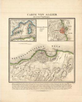
- Maps and Prints
ALGIERS, Algeria: Carte von Algier mit seinen Umgebungen.
- 450.00€
- A rare, seemingly unrecorded lithographed broadside, printed in Switzerland, shows Algiers, besieged by French in 1830.
- Add to cart
-
- Americas, Maps and Prints, New Acquisitions: October 2020
AMERICA – OTTOMAN SCHOOL ATLAS: آمريقا [Amerika]
- 380.00€
- 8°. 29-35 pp., facing pages marked with the same number, with colour lithographed plates, printed covers, stapled (tiny loss of paper in the lower corners of the last pages, light staining and foxing, otherwise in a good used condition).
- Add to cart
-
- Africa, Maps and Prints
ANGOLA – EARLY OIL (PETROLEUM) EXPLORATION: [Set of 2 Cyanotype Maps and 1 Line Chart of 1920s Oil Exploration in Angola].
- 1,800.00€
- A trio of very large format diagrams (2 blueprint maps, 1 line chart) made for the Companhia de Petróleo de Angola in the 1920s, when it was prospecting the Cuanza (Kwanza) Basin, one of Africa’s great petroleum deposits; the works were drafted by James J. McGowan, a larger-than-life Irish-American engineer who later became a pillar of Luanda’s business community; the…
- Add to cart
-
- Europe, Maps and Prints, Turkey
Ankara
- 350.00€
- Colour print, 63 x 46 cm (inches) (soft folds, minor age-toning, but overall in a good condition). A decorative late art deco map showcases Ankara with its modern neighborhoods
- Add to cart
-
- Americas, Caribbean, Maps and Prints
Antigua in the West Indies America. Laid Down by actual Survey, and engraved by John Luffman, in the years 1787 and 1788. / To His Excellency Major General Sir Thomas Shirley Governor Bart. Captain General & Governor in Chief in and over all His Majestys Leeward Caribee Islands, in America. Chancellor, Vice Admiral & Ordinary of the same. This Map is Dedicated, by his obliged humble Servant, John Luffman.
- 9,500.00€
- John Luffman’s grand map of Antigua, one of the cartographic monuments of the 18th century British West Indies; predicated upon the goldsmith-cartographer’s reconnaissance of the island conducted when it was still one of the world’s leading sugar-slave economies, as well as hosting a major Royal Navy base (then commanded by the future Lord Admiral Horatio Nelson); the map served as…
- Add to cart
-
- Americas, Caribbean, Maps and Prints
ANTIGUA, WEST INDIES / SLAVERY & EMANCIPATION: A New & Improved Map of the Island of Antigua, in the West Indies. Constructed and drawn chiefly from original Materials and most Recent Surveys. By J. Johnson.
- 9,500.00€
- J. JOHNSON. London: Smith, Elder & Co., August 1829. Copper engraving and aquatint with full original wash hand colour, dissected into 6 sections and mounted upon original linen (Very Good, resplendent original colours and gorgeous print quality, just some light toning and minor print transference), 73.5 x 82.5 cm (29 x 32.5 inches) (#70644a). Exceedingly rare – one…
- Add to cart
-
- Asia, Europe, Maps and Prints, Middle East, Near East, Turkey
ARABIAN PENINSULA / OTTOMAN EMPIRE: اسياى غرب [West Asia]
- 280.00€
- Lithograph with original colour: 18 x 23 cm (7 x 9 inches) (soft fold, slightly stained in the upper margin).
- Add to cart
-
- Maps and Prints, Middle East, New Acquisitions: September 2020
ARABIAN PENINSULA:جزيرة العرب [Arabian Peninsula]
- 550.00€
- Chromolithograph. 9 x 13,5 cm (3.5 x 5.3 inches). Slightly stained.
- Add to cart
-
- Maps and Prints
ARCHAEOLOGY / TURKEY / HERACLEA PONTICA: “figuré par M. Allier, Csul de france à Héraclée du Pont, le 15 9bre, 1806”.
- 1,500.00€
- An intriguing original manuscript sketch map of Heraclea Pontica (modern Karadeniz Ereğli), one of the most important Greco-Roman historical sites along the Black Sea coast of Anatolia, made in 1806 by Louis Allier de Hauteroche, the esteemed archaeologist and numismatist who was then Napoleon’s vice-consul to the region.
- Add to cart
-
- Others
ARMENIA / SOVIET ARMENIA / ATLAS: Հայկական Սովետական Սոցիալիստական Ռեսպուբլիկայի Ատլաս [Atlas of the Armenian Socialist Republic].
- 1,400.00€
- A Armenian language edition of the first thematic atlas of Armenia; one of the most impressive and engaging works of Soviet scientific cartography, featuring 97 full-page, full-colour plates of sophisticated maps plus diagrams covering virtually all aspects of the geography, geology, economy, transport and demographics of the Armenian SSR; predicated upon years of careful research and draughtsmanship by the Armenian…
- Add to cart
-
- Armenia, Europe, Maps and Prints
ARMENIA: Армянская ССР. Экономическая учебная карта [Armenian SSR. School Map of Economy]
- 250.00€
- Colour lithography, 87 x 77 cm (34.2 x 30.3 cm) (tiny holes on the crossings of the folds, otherwise in a good condition).
- Add to cart
-
- Maps and Prints
ARMENIAN & OTTOMAN SCRIPT – PORTRAIT: Mehmed V.
- 850.00€
- A very rare larger portrait of Mehmed V with titles in Ottoman and Armenian script, was published for the occasion of his investiture in 1909, only days after the massacre of Armenians in Adana. The Armenian Genocide under the reign of Mehmed IV happened six years later.
- Add to cart
-
- Armenian Books, Books, Maps and Prints
ARMENIAN CALLIGRAPHY / LABYRINTH: Arma Christi
- 2,800.00€
- This manuscript broadside is a stunning example of artistry, seamlessly blending Armenian calligraphy with its distinctive letters and rich Christian symbolism that is deeply embedded in the nation’s identity. The inclusion of a traditional labyrinth form elevates the piece, serving as a profound tool for meditation and concentration. Drawing and manuscript in various colours on paper, 62 x 44…
- Add to cart
-
- Others
Armenian Manual on Sexuality for Men: ՄՏԵՐԻՄ ԶՐՈՒՅՑՆԵՐ ՍԵՌԱԿԱՆ ԿԵԱՆՔԻ ՄԱՍԻՆ.
- 750.00€
- [Confidential Conversations about Sexual Life]. A rare manual on sexuality and impotence, printed in the Armenian Language in Istanbul. 8°: 223 pp., original illustrated wrappers (good, wrappers with minor staining and small tears and tiny loss of paper to spine, minor old annotation in blalck ink on the cover).
- Add to cart
-
- Maps and Prints
ARSENAL OF VENICE, ITALY: Plan général de l’Arsenal de Venise.
- 3,500.00€
- A unique manuscript map by one of the most important Venetian map-makers of the early 19th century Bernardo Combatti, shows the Arsenal, as rebuilt by Napoleon around 1810, to the form known today. The Arsenal today hosts the Venetian Biennale.
- Add to cart
-
- Maps and Prints
ART-DECO FINE ART: Sence ali knjiga lesorezov in linorezov [Shadows or a Book of Woodcuts and Linocuts].
- 950.00€
- A book with original artwork. A numbered example, signed by the author.
- Add to cart
-
- Europe, Maps and Prints
Artois Atrebatum Regionis Vera Descriptio Johanne Surhouio monte Auctore
- 11,500.00€
- An exceedingly rare map by Gerard de Jode, printed only as a broadside after the publication of his atlas of 1578.
- Add to cart
-
- Maps and Prints
ASIA: اسيا [Asya / Asia] 2nd Edition
- 480.00€
- A rare book in Ottoman script on Asia, richly illustrated with black and white photographs and maps.
- Add to cart
-
- Europe, Maps and Prints, Turkey
ATATÜRK / TURKISH REPUBLICANISM: انا وطن [Ana Vatan / Homeland].
- 3,200.00€
- سودى نك يكى خريطه كلياتندن [SÛDÎ’NIN YENI HARITA KÜLLIYATINDAN / SUDI’S NEW CARTOGRAPHIC ESTABLISHMENT]. Istanbul: كتابحانه سودى [Kitaphane-yi Sûdî] 1927. Colour off-set print (Good, light stains mostly visiable verso, some wear along fold folds, tiny chips to the folds in the image and in the margins), 67 x 100 cm (26.5 x 39.5 inches). ‘Ana Vatan’ (Homeland) is one of…
- Add to cart

![ALEPPO, SYRIA & TURKEY: حلب ولآيت [HALEP VILAYET / ALEPPO VILAYET].](https://pahor.at/wp-content/uploads/2020/06/65983-265x331.jpg)
![Alexander von Humboldt in seiner Bibliothek [Alexander von Humboldt in His Library]](https://pahor.at/wp-content/uploads/2025/09/Mai25_2-Recovered-265x331.jpg)
![AMERICA – OTTOMAN SCHOOL ATLAS: آمريقا [Amerika]](https://pahor.at/wp-content/uploads/2020/10/69080_2-265x331.jpg)
![ANGOLA – EARLY OIL (PETROLEUM) EXPLORATION: [Set of 2 Cyanotype Maps and 1 Line Chart of 1920s Oil Exploration in Angola].](https://pahor.at/wp-content/uploads/2025/10/June25_45-copy-265x331.jpg)


![ARABIAN PENINSULA / OTTOMAN EMPIRE: اسياى غرب [West Asia]](https://pahor.at/wp-content/uploads/2022/02/2022-02-05_144645-copy-265x331.jpg)
![ARABIAN PENINSULA:جزيرة العرب [Arabian Peninsula]](https://pahor.at/wp-content/uploads/2020/08/68977-6-4-265x331.jpg)


![ARMENIA / SOVIET ARMENIA / ATLAS: Հայկական Սովետական Սոցիալիստական Ռեսպուբլիկայի Ատլաս [Atlas of the Armenian Socialist Republic].](https://pahor.at/wp-content/uploads/2023/12/IMG_9560-copy-265x331.jpg)
![ARMENIA: Армянская ССР. Экономическая учебная карта [Armenian SSR. School Map of Economy]](https://pahor.at/wp-content/uploads/2022/10/69870-265x331.jpg)


![ART-DECO FINE ART: Sence ali knjiga lesorezov in linorezov [Shadows or a Book of Woodcuts and Linocuts].](https://pahor.at/wp-content/uploads/2020/06/65198-265x331.jpg)

![ASIA: اسيا [Asya / Asia] 2nd Edition](https://pahor.at/wp-content/uploads/2020/06/2019-05-28_193436-265x331.jpg)
![ATATÜRK / TURKISH REPUBLICANISM: انا وطن [Ana Vatan / Homeland].](https://pahor.at/wp-content/uploads/2024/03/Febreiro20-copy-265x331.jpg)