-
- Maps and Prints
ATLANTIC CANADA: Carte Réduite des Bancs et de l’Ile de Terre Neuve avec les Côtes du Golfe de St. Laurent et de L’Acadie.
- 750.00€
- A fine example the authoritative chart used by the French Government to manage their fishing rights in Newfoundland and the Grand Banks, in part based on the magisterial surveys of Newfoundland by James Cook & Michael Lane and Samuel Holland’s survey of the Island of St. John (Prince Edward Island).
- Add to cart
-
- Africa, Books, Geography, Maps and Prints
ATLAS – MISSIONS IN AFRICA AND CHINA: Karten über das Arbeitsfeld der Berliner Mission.
- 550.00€
- A very rare atlas made by the Berlin Missionary Society, one of the most important missionary organizations in Africa and China during the 19th and early 20th Centuries, featuring 16 original maps made by missionary cartographers, including important figures such as Alexander Merensky and Bernhard Struck, containing 14 maps of South and East Africa and 2 maps of China;…
- Add to cart
-
- Australia, Maps and Prints, Oceania
Australia / German New Guinea: Neue Karte von Australien von Prof. Fr. Behr. Verlag von Juilus Maier in Stuttgart. 1888.
- 850.00€
- An exceedingly rare and attractive large format map of Southeast Asia, Australia and Polynesia, with a special emphasis upon the new colony of ‘Deutsch-Neuguinea’, a ‘boutiquey’ provincial production drafted by Professor Franz Behr and published in Canstatt, just outside of Stuttgart. Colour lithograph, dissected into 8 sections and mounted upon original linen with original red silk edging, folding…
- Add to cart
-
- Australia, Maps and Prints, Newly Catalogued Items: August 2022
AUSTRALIA / NEW GUINEA – WORLD WAR II: 濠州詳細圖 附ニユーギニア [Gōshū shōsai zu fu niyūginia / Detailed Map of Australia with New Guinea].
- 950.00€
- A very rare and unusually attractive large format WWII Japanese map of Australia, New Guinea and the Eastern Indonesian Archipelago, made in 1942, the year that the Japanese Air force mounted the shocking ‘Bombing of Darwin’, the largest ever attack upon Australia mounted by a foreign power, and just before the Allies endeavoured to take the offensive in New…
- Add to cart
-
- Australia, Maps and Prints, New Acquisitions: December 2020, New Zealand
AUSTRALIA AND OCEANIA: يكى اوقيانوسيا [New Oceania]
- 850.00€
- A very rare, large format, separately issued map of Australia and Oceania that is perhaps the last great map of the continent to be printed in Ottoman Turkish script, with attractive colours and adorned with the flags of major African states and colonies, published in Istanbul for the Kitabhane-yi Sudi bookshop. Colour off-set print (Good, some light staining, wear…
- Add to cart
-
- Australia, Maps and Prints
AUSTRALIA: اوستراليا [Australia]
- 450.00€
- Chromolithograph, 51 x 34 cm (13.4 x 20 inches), (small repaired tears in the fold, sporadic light staining in white margins, but otherwise in a good condition).
- Add to cart
-
- Australia, Maps and Prints
AUSTRALIA: قطعه اوثآن غربى [Part of the Western Ocean]
- 300.00€
- Lithograph with original colour: 18 x 23 cm (7 x 9 inches) (soft fold, slightly age-toned and stained).
- Add to cart
-
- Maps and Prints
AUTOGRAPH: Zlatko Baloković (1895 – 1965).
- 250.00€
- A photo with an autograph of Zlatko Baloković, a famous Croatian violinist, visible figure among the Yugoslavian immigrants to the United States, and a personal friend of Nikola Tesla, who played Ave Maria and a Serbian song Tamo daleko, when New York City mayor Fiorello La Guardia read Tesla’s eulogy on the radio.
- Add to cart
-
- Maps and Prints, Newly Catalogued Items: August 2022, World Maps
AVIATION HISTORY / FIRST JAPANESE TRANS-EURASIAN FLIGHT / SUGOROKU BOARDGAME: 歐訪大飛行記念飛行遊戯 [Ōhō daihikō kinen hikō yūgi / Great European Visit Memorial Flight Game].
- 680.00€
- An attractive cartographic ‘Sugoroku’ gameboard commemorating the 1925 Asahi Shinbun Trans-Eurasian flight, a major landmark of early aviation, whereby two Japanese planes flew from their homeland over 16,500 km to tour various European capitals as part of a patriotic PR tour to showcase Japan’s role as world power, printed by the mission’s sponsor, the ‘Asahi Shinbun’, a leading Japanese…
- Add to cart
-
- Asia, Europe, Maps and Prints, Near East
Azerbaijan SSR: Azerbajcanın sijasi va təbii Xərıtəsi [Political and Natural Map of Azerbaijan]
- 2,800.00€
- The first wall map of Azerbaijan SSR, made in 1925 by a pioneer of Azerbaijani map-making İbrahim Ağa Vəkilov Colour lithography, printed on four sheets and originally mounted on linen, 100 x 135 cm (39.8 x 53.1 inches) (small tears, folds and holes with tiny loss of material, light staining).
- Add to cart
-
- Maps and Prints
BADEN, SWITZERLAND: Kursaal. Baden. Schweiz. Suisse. Switzerland
- 320.00€
- A stunning brochure in Art Nouveau style was made by a Swiss artist and poster designer Otto Baumberger for a spa resort Baden.
- Add to cart
-
- Maps and Prints, Middle East
Baghdad Region, Iraq – World War I / Mesopotamian Campaign / Calcutta Imprint: Bāghdād. Turkey in Asia and Persia. (Rough Provisional Issue, Second Edition) / No. 2C. [Baghdad Region].
- 1,500.00€
- The seminal map of the Baghdad region used by British Imperial forces during World War I’s Mesopotamian Campaign for operational planning during their two attempts to take the Iraqi capital, being the extremely rare ‘Degree Sheet’ survey of the area predicated upon the best available sources, published in 1915 in Calcutta by the Survey of India on the orders of…
- Add to cart
-
- Maps and Prints
BAGHDAD, IRAQ: Directorate General Passenger Transport Service / Baghdad Bus Map.
- 220.00€
- A scarce and detailed map of circa 1960 Baghdad, capturing the city during a period of rapid development due to the on-going oil boom, made by the local public transit authority to show bus routes.
- Add to cart
-
- Maps and Prints, Middle East, New Acquisitions: September 2020
BAGHDAD: بغداد ولايتى [Baghdad Vilayeti]
- 180.00€
- Postcard. Lithography in colour (Very Good, slightly age-toned, tiny tears and chips in margins ) 10 x 14cm (5.11 x 3.5 inches).
- Add to cart
-
- Bindings, Books, Others
BATAVIA (JAKARTA) / IMPRINT: Verslag over het jaar 1867, zamengesteld door de Kamer van Koophandel en Nijverheid te Batavia.
- 1,500.00€
- A resplendent and unique presentation piece given to Pieter Meijer, the Governor-General of the Dutch East Indies (Indonesia), being the very rare economic yearbook for the colony for 1867, custom bound in sumptuous full red morocco with elaborate gilt neo-rococo designs and bearing a dedication to the His Excellency; published locally by the Chamber of Commerce and Industry in Batavia,…
- Add to cart
-
- Maps and Prints, Middle East
BATTLE OF ALEPPO / PURSUIT TO HARITAN / MANUSCRIPT MILITARY FIELD ANNOTATIONS: Karte von Mesopotamien und Syrien / Aleppo.
- 1,500.00€
- A stellar and unique artefact of World War I in the Middle East - an advanced topographical map of north-western Syria and the adjacent parts of Anatolia issued by the German Army in May 1918, with extensive contemporary manuscript additions in coloured crayon added by an Ottoman officer depicting the key military actions during the Battle of Aleppo and the…
- Add to cart
-
- Maps and Prints
BATTLE OF DUMLUPINAR, TURKEY: Büyük Taarruz Ve Başkumandan Meydan Muharebesi [Great Offensive and Commander-in-Chief Battle].
- 420.00€
- A fascinating, extremely rare Turkish 20th century map by a military historian Hakki Tümerdem shows the development of the Battle of Dumlupınar, the last battle in the Greco-Turkish War in 1922.
- Add to cart
-
- Maps and Prints
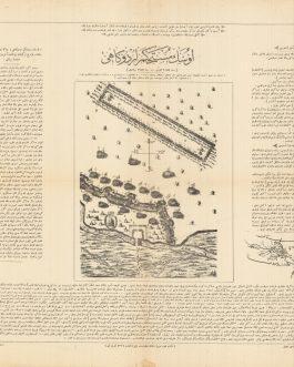
Battle of Mohács 1526, HUNGARY: مهاچ ميداز مجاربى سى
- 550.00€
- A very rare broadside with Ottoman script showing the Battle of Mohács was made in the series of large separately published maps by the Turkish War Office the late Hamidian period as a part of intellectual propaganda to revive patriotic sentiment.
- Add to cart
-
- Maps and Prints
Battle of Saint Gotthard, HUNGARY: سنغوتار ميداز محاربى سى
- 480.00€
- A very rare broadside with Ottoman script showing the Battle of Saint Gotthard was made in the series of large separately published maps by the Turkish War Office the late Hamidian period as a part of intellectual propaganda to revive patriotic sentiment.
- Add to cart


![AUSTRALIA / NEW GUINEA – WORLD WAR II: 濠州詳細圖 附ニユーギニア [Gōshū shōsai zu fu niyūginia / Detailed Map of Australia with New Guinea].](https://pahor.at/wp-content/uploads/2022/08/Aprillmap17-copy-265x331.jpg)
![AUSTRALIA AND OCEANIA: يكى اوقيانوسيا [New Oceania]](https://pahor.at/wp-content/uploads/2020/12/69234-265x331.jpg)
![AUSTRALIA: اوستراليا [Australia]](https://pahor.at/wp-content/uploads/2022/10/69871-265x331.jpg)
![AUSTRALIA: قطعه اوثآن غربى [Part of the Western Ocean]](https://pahor.at/wp-content/uploads/2022/02/Dokument_2022-02-05_145045-copy-265x331.jpg)
![AUSTRIA: Die Agrarischen Operationen in Österreich [The Agrarian Operations in Austria].](https://pahor.at/wp-content/uploads/2020/06/67309-265x331.jpg)

![AVIATION HISTORY / FIRST JAPANESE TRANS-EURASIAN FLIGHT / SUGOROKU BOARDGAME: 歐訪大飛行記念飛行遊戯 [Ōhō daihikō kinen hikō yūgi / Great European Visit Memorial Flight Game].](https://pahor.at/wp-content/uploads/2022/08/Julimap1-copy-265x331.jpg)
![Azerbaijan SSR: Azerbajcanın sijasi va təbii Xərıtəsi [Political and Natural Map of Azerbaijan]](https://pahor.at/wp-content/uploads/2022/06/IMG_8802-Recovered-265x331.jpg)

![Baghdad Region, Iraq – World War I / Mesopotamian Campaign / Calcutta Imprint: Bāghdād. Turkey in Asia and Persia. (Rough Provisional Issue, Second Edition) / No. 2C. [Baghdad Region].](https://pahor.at/wp-content/uploads/2020/07/mecca_33-265x331.jpg)

![BAGHDAD: بغداد ولايتى [Baghdad Vilayeti]](https://pahor.at/wp-content/uploads/2020/09/68976-4-265x331.jpg)


![BATTLE OF DUMLUPINAR, TURKEY: Büyük Taarruz Ve Başkumandan Meydan Muharebesi [Great Offensive and Commander-in-Chief Battle].](https://pahor.at/wp-content/uploads/2020/06/65870-265x331.jpg)