-
- Maps and Prints, Middle East
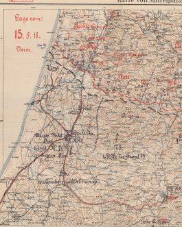
WWI MIDDLE EAST – BATTLE OF MEGIDDO: Karte von Mittelpalastina. / Ostjordanland südl. Teil. / ““Geheim!” Lage vom: 15.8.18”.
- 2,200.00€
- An incredibly important survivor – a top-secret ‘General Headquarters Map’ made for the use of German General Liman von Sanders and his senior staff to oversee the ill-fated Ottoman-German ‘last stand’ in World War I’s Palestine Campaign at the ‘Battle of Megiddo’; composed of two joined exceedingly rare topographical maps of Central Palestine and Eastern Jordan, drafted and printed…
- Add to cart
-
- Maps and Prints, Middle East, New Acquisitions: December 2020
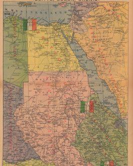
WWI PALESTINE / ISRAEL / BATTLE OF JERUSALEM: Syria / Jerusalem (Kuds-Esh-Sherif).
- 1,200.00€
- Rare – one of the most important of the maps made by the Egyptian Expeditionary Force during World War I, depicting Southern Palestine with the Ottoman-German Gaza-Beersheba defensive line, as well as the vicinity of the Battle of Jerusalem (1917), one the great British triumphs of the war in the Middle East, published in Cairo by the Survey of Egypt…
- Add to cart
-
- Maps and Prints
WWII / PLANNED ALLIED INVASION OF FRANCE / PICTOGRAPHIC MAP: [Untitled Map showing the Proposed Routes for an Allied Invasion of Nazi Occupied North-Western Europe…Cumhuriyet, 5 Birinciteşrin 1943].
- 140.00€
- An attractive Turkish pictographic map showing the various options that the Allies had for invading Nazi occupied north-western Europe, from an October 1943 edition of the leading Turkish daily ‘Cumhuryet’, published eight months before D-Day.
- Add to cart
-
- Africa, Europe, Maps and Prints, New Acquisitions: November 2020
WWII IN NORTH AFRICA / SICILY / D-DAY / FRANCE / GERMANY / SOLDIERS’ ITINERARY CARTOGRAPHY: The Route of The Ninth Division Thru the Natousa & Etousa Nov. 8, 1942 – June 1945.
- 650.00€
- A fascinating itinerary map of the route of the U.S. Army’s Ninth Infantry Division during their World War II active combat tours, featuring their routes in North Africa, Sicily, England, France (including the D-Day Landings) and Germany; published in Germany only 2 months after the end of the war as a memento for the troops – notably, one of only…
- Add to cart
-
- Europe, Maps and Prints, New Acquisitions: October 2020, Portugal
WWII POLAND – ŁÓDŹ / HOLOCAUST: Plan der Stadt Lodsch.
- 850.00€
- A deeply disturbing but historically important map depicting Łódź, Poland shortly after it was conquered by the Nazis in early World War II; all the of place and street names have been changed from Polish to German nomenclature and all signs of the city’s Polish population and Jewish community (which numbered over 30% of the city’s residents) has been erased;…
- Add to cart
-
- Maps and Prints, Middle East, New Acquisitions: October 2020
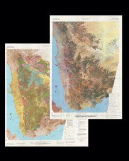
YEMEN (NORTH) GEOLOGICAL MAP / SATELLITE PHOTOGRAPHIC CARTOGRAPHY / PETROLEUM INDUSTRY
- 1,200.00€
- An impressive paring of colossal related maps, being 1) a map of North Yemen (a country that existed from 1967 and 1990, until Yemen was unified) constructed from NASA Landsat imagery, leading to the creation of 2) the first edition of the first scientific geological map of North Yemen; highly sophisticated works created by the geologists Maurice J. Grolier and…
- Add to cart
-
- Maps and Prints, Middle East
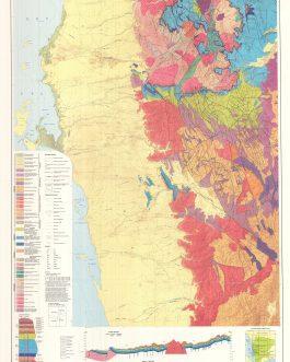
Yemen (North) Geological Map Printed On 4 Separately Issued Sheets
- 1,200.00€
- The first edition of the first scientific geological map of North Yemen, officially the Yemen Arab Republic (centred on its capital Sana’a), a country that existed between 1967 and 1990, until Yemen was unified; a highly sophisticated work published on 4 large, brightly coloured sheets in Hannover by West Germany’s Federal Institute of Geosciences and Natural Resources, predicated upon…
- Add to cart
-
- Books, Geography, Maps and Prints, Middle East, Ottoman Books, Turkica
YEMEN, SAUDI ARABIA, MECCA: يمن لايحه سى [Yemen Lâyıhası. Yemen ahvalinin ıslahı hakkında Siverek meb’usı Nureddin Bey tarafından Meclis-i Mebusan-i Osmaniye takdım kılınan layihadır]
- 1,600.00€
- [Report on Yemen. A Statement about the Improvement of the Situation in Yemen, Presented to the Ottoman Parliament by deputy Nureddin Bey from Siverek] 8°, 48 pp., folding colour map, later brown cloth binding with mounted original wrappers (wrappers slightly age-toned and stained with tiny pieces of paper missing, inside in overall good condition).
- Add to cart
-
- Maps and Prints
YEMEN: Tabula Itineraria sistens illam partem Terrae Yemen
- 400.00€
- Deatailed early road map of Yemen, made by Carsten Niebuhr based on surveys from a scientific expedition sponsored by Frederick V of Denmark
- Add to cart
-
- Maps and Prints
YEREVAN, ARMENIA: [Map:] Ереван – иллюстрированная панорамная схема. [Cover:] Ереван. Туристская схема [Yerevan – Illustrated Panoramic Map. Tourist Map]
- 550.00€
- Coulour lithorgraph, 70 x 62 cm (27.6 x 24.4 inches), (soft folds, overall in a good condition).
- Add to cart


![WWII / PLANNED ALLIED INVASION OF FRANCE / PICTOGRAPHIC MAP: [Untitled Map showing the Proposed Routes for an Allied Invasion of Nazi Occupied North-Western Europe…Cumhuriyet, 5 Birinciteşrin 1943].](https://pahor.at/wp-content/uploads/2020/06/68804-265x331.jpg)


![WWII PRISON MUSIC & ART: IV. broj Usmenih novina, Proslava 800 Godina Moskve [4th issue of the Oral Newspaper. Celabration of 800th Anniversary of Moscow].](https://pahor.at/wp-content/uploads/2020/06/65206-265x331.jpg)
![YEMEN, SAUDI ARABIA, MECCA: يمن لايحه سى [Yemen Lâyıhası. Yemen ahvalinin ıslahı hakkında Siverek meb’usı Nureddin Bey tarafından Meclis-i Mebusan-i Osmaniye takdım kılınan layihadır]](https://pahor.at/wp-content/uploads/2023/01/69949-265x331.jpg)

![YEREVAN, ARMENIA: [Map:] Ереван – иллюстрированная панорамная схема. [Cover:] Ереван. Туристская схема [Yerevan – Illustrated Panoramic Map. Tourist Map]](https://pahor.at/wp-content/uploads/2021/07/69384-265x331.jpg)