-
- Maps and Prints
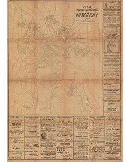
WARSAW, POLAND: Poczta, telegraf i telefon na terenie m. st. Warszawy [Post, Telegraph and Telephone in the Area of the City of Warsaw].
- 350.00€
- The first and only edition of a decorative Art Deco map of Warsaw shows post, telegraph and telephone stations in 1936.
- Add to cart
-
- Maps and Prints
WATER-COLOUR MINIATURE PORTRAIT: Karl Freiherr von Schrenck (1806-1884)
- 650.00€
- A unique Bidermeier hand painted miniature portrait of young Karl Freiherr von Schrenck, a later famous lawyer and Bavarian minister of Justice, fired for signing a memorandum against Lola Montez.
- Add to cart
-
- Maps and Prints, New Zealand
Wellington, New Zealand: Map of the City of Wellington and Surrounding Dist.
- 2,800.00€
- An extremely rare, large format work that is the first edition one of the seminal maps of Wellington, depicting the New Zealand capital when it was one of the fastest growing cities in the British Empire, with a wealth of finely executed and intriguing details, granting a peerless record of the city as it was, as well as prefiguring…
- Add to cart
-
- Americas, Caribbean, Maps and Prints
WEST INDIES – HISPANIOLA – HAITI – DOMINICAN REPUBLIC: Carte physique et politique de l’Ile d’Haïti / Dressée par Mr. A. Poujol, Ancien Chargé d’Affaires d’Haïti á Santo Domingo et Ancien Membre des Commission mixte de délimitation de 1899 et 1901 et Mr. H. Thomasset, Ingénieur de l’Ecole Centrale de Paris, Officier de la Légion d’Honneur. Publiée sous le Ministère de Mr. T. Laleu, Sécretaire d’Etat aux Départments de l’Instrucion Publique et de la Justice, Port-au-Prince, 1908. / Nouvelle édition rectifiée 1912.
- 4,800.00€
- Extremely rare - a monumental, brilliantly colour lithographed work that is by far and away the most accurate and detailed map of Hispaniola to date, and one of the great achievements of cartography of the early 20th century in the Americas, the result of a collaboration between Alexandre Poujol, a leading Haitian jurist and stateman, and Henri Thomasset, a Frenchman…
- Add to cart
-
- Maps and Prints
WEST INDIES – TRINIDAD / JUDICIAL MURDER & SORCERY / RACE RELATIONS / CELEBRITY TRIALS / PROPAGANDA WARS / SCOTTISH PROVINCIAL IMPRINT: [A Letter:] To Field Marshal, H.R.H. The Duke of York, Air, Scotland, 15th June, 1807.
- 980.00€
- Seemingly unrecorded - a content-rich Scottish broadside, being on open letter written by Colonel William Fullarton, a prominent liberal statesman, addressed to the Duke of York, the Commander-in-Chief of the British Army; created as part of the former’s legal and propaganda war against General Thomas Picton (later famous for his final act at the Battle of Waterloo), who had…
- Add to cart
-
- Europe, Maps and Prints, Portugal
Wine Map of Porto, Portugal: Visitez les Chais de vin de Porto de Porto Cintra. Warre Ca. Lda.
- 120.00€
- Colour lithograph, printed from both sides, 46 x 62 cm (24.4 x 18.1 inches) (soft folds, but otherwise in a good condition).
- Add to cart
-
- Maps and Prints, World Maps
WORLD MAP – AVIATION HISTORY – JAPANESE BOARD GAME OSAKA: 征空すごろく [Sugoroku Conquest].
- 750.00€
- An amazing Japanese celebration of the Early Aviation Age, being a large format World map that doubles as a ‘Sugoroku’ gameboard, inviting players to explore every part of the globe by either airplane or Zeppelin airship. Colour print (Very Good, overall clean and bright, some light wear along old folds and at edges and some tiny holes at…
- Add to cart
-
- Maps and Prints
WORLD MAP / GLOBAL SHIPPING / NEW YORK / ‘ALEXANDRA LAND’, AUSTRALIA: Map Showing the Routes of the Norddeutscher Lloyd Steamship Company in All Parts of the World.
- 350.00€
- An extremely rare – seemingly unrecorded – late 19th Century ephemeral work promoting the Norddeutscher Lloyd Steamship Line, featuring a World Map of all its routes, a map of New York City and lengthy text on the line’s contemporary operations; published in new York likely to aide German travellers and immigrants – plus the World map features an interesting…
- Add to cart
-
- Maps and Prints, Middle East, New Acquisitions: September 2020
WORLD WAR I MIDDLE EAST / LEBANON / ISRAEL / PALESTINE / SYRIA / JORDAN / EGYPT / SUEZ CANAL: Operationskarte / Beirut.
- 650.00€
- Rare - a seminal map used for strategic planning by German commanders during the Sinai and Levant theatre of World War I, a classified work created under the supervision of the orientalist Franz Gustav Taeschner for the German General Staff, it depicts all details necessary to inform broad military movement during one of the most dramatic and surprising campaigns of…
- Add to cart

![WARSAW, POLAND: Poczta, telegraf i telefon na terenie m. st. Warszawy [Post, Telegraph and Telephone in the Area of the City of Warsaw].](https://pahor.at/wp-content/uploads/2020/06/65416-265x331.jpg)


![WEST INDIES – TRINIDAD / JUDICIAL MURDER & SORCERY / RACE RELATIONS / CELEBRITY TRIALS / PROPAGANDA WARS / SCOTTISH PROVINCIAL IMPRINT: [A Letter:] To Field Marshal, H.R.H. The Duke of York, Air, Scotland, 15th June, 1807.](https://pahor.at/wp-content/uploads/2020/06/68251-265x331.jpg)


![WORLD MAP – AVIATION HISTORY – JAPANESE BOARD GAME OSAKA: 征空すごろく [Sugoroku Conquest].](https://pahor.at/wp-content/uploads/2022/03/Maiomap12-265x331.jpg)

