-
- Broadsides, Maps and Prints, September 2023: 50 under 1000 EUR
VENICE / PLAGUE: Illustriss. Sig. Sig. Osservandiss. Si vanno rendendo sempre maggiori li motivi di riguardo per la dilatazione del Contagio nella Morea, e Rumelia…
- 180.00€
- [The reasons for consideration for the spread of the contagion in the Morea, and Rumelia are becoming ever greater…] Broadside, letterpress on thin laid paper with a watermark, 28 x 19 cm (11 x 7.5 inches).
- Add to cart
-
- Books, Broadsides, German Books
VETERINARY MEDICINE / SUPERSTITION: Cinguli ad mensuram caelitus allatae imaginis D.P. Dominici in Soriano contra luem animalium ad collum eorum appendendi.
- 420.00€
- A rare four-page pamphlet with two somehow different solutions on fighting the pandemic of rinderpest (Lues animalium) in South Germany, in 1732. 8°, 4 pp. with a wood-cut on the last page (Very Good, uncut edges with light soiling).
- Add to cart
-
- Others
VIETNAM – TÂN AN, LONG AN PROVINCE: “Poste de Tanan”.
- 1,800.00€
- Intriguing, unique, and historically important – one of only very few surviving original manuscript plans of the archetype army bases established in key towns across French Indochina (today’s Vietnam and Cambodia) that were the foundation of colonial power in the region; the present finely rendered and highly detailed plan showcases the French army base at Tân An, a provincial capital…
- Add to cart
-
- Asia, Maps and Prints, South-East Asia
Vietnam / Cambodia / Laos (Indochina) / French Conquest Of Vietnam: Carte de L’Indo-Chine Orientale dressée par Mr. J.L. Dutreuil De Rhins publiée sous le Ministère de Mr. le Vice Amiral Jaureguiberry. Au Dépôt des Cartes et Plans de la Marine en 1881.
- 6,500.00€
- A colossal monument of the cartography of Indochina, being the grand ‘Headquarters Map’ of Vietnam, Cambodia, Laos and eastern Siam commissioned by the French Government in anticipation of their bold designs of expansion in the region that led to the Tonkin Campaign (1883-6), the complete conquest of Vietnam; showcasing by far and away the most accurate and detailed general…
- Add to cart
-
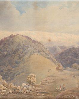
- India, Maps and Prints
View of the Foothills of the Himalayas
- 8,500.00€
- A beautifully executed mid-19th century watercolor view of the foothills of Himalayas with snowed mountain range in the background. Water-colour drawing, 34 x 49 cm (13.4 x 19.3 inches) on J Whatman wove paper, mounted on later paper (little sun-toned and with light staining and foxing, one tiny hole in the center of one of the stains, but overall…
- Add to cart
-
- Maps and Prints
VOLCANISM WORLD MAP: Südliche und Noerdliche Halbkugel der Erde nach den neuesten Entdeckungen der Vulkanischen-Linien.
- 650.00€
- An uncommon map of the World with marked vulcanic lines was published to accompany a scientific article by a German researcher of antiquity and Egyptologist Friedrich Sickler in 1812.
- Add to cart
-
- Europe, Maps and Prints, Russia
VYBORG (Выборг / VIIPURI), RUSSIA: [Proof State – Carte du Golfe de Wibourg à la Côte de Karèlie].
- 1,500.00€
- A proof state of an exceptionally rare sea chart of Vyborg Harbour, Russia, prepared for Charles-Pierre Fleurieu’s grand atlas of the Baltic Sea.
- Add to cart
-
- Australia, Maps and Prints, Oceania
Wall Map of Australia: Specialkarte von Australien in 9 Blättern nach originalen & officiellen Quellen von A. Petermann
- 680.00€
- [Special Map of Australia in 9 Sheets, after Original and Official Sources by A. Petermann] A rare, separately issued Petermann’s map of Australia on 9 sheets with old colour, originally mounted on linen and joined together in a wall map, printed by the finest German cartographic office. Original coloured lithography, 98 x 122 cm (38.6 x 48…
- Add to cart
-
- Others
WALL-MAP OF THE CAUCASUS / TIFLIS IMPRINT: Дорожная Карта Кавказскаго Края Составлена и Литографирована въ Военно-Топографическомъ Отдѣлѣ Кавказскаго Военнагоокруга.
- 4,800.00€
- A rare detailed wall-map of the Caucasus, printed in Tiflis and drafted by Military Topographic Department of the Caucasus Military District under the leadership of the prolific surveyor Hieronymus Stebnitsky
- Add to cart
-
- 16th and early 17th Century Prints, Maps and Prints
WAPPEN / COAT OF ARMS: Kardinal aus der Familie Aldobrandini (?)
- 400.00€
- Blatt mit kardinalischem Wappen, allegorischen und heiligen Figuren, gestochen von Pieter de Jode d. Ä. nach einer Zeichnung von Francesco Vanni.
- Add to cart
-
- Maps and Prints, Newly Catalogued Items: August 2022, Posters, Slavica
WARSAW UPRISING UNDERGROUND PRINTING: Warszawa Walczy żołnierska gazeta scienna. [Warsaw Fights: Soldiers’ Wall Newspaper], Nr. 40, August 19th, 1944
- 950.00€
- A very rare issue of ‘Warszawa Walczy’ [Warsaw Fights], a large illustrated broadside ‘wall newspaper’ issued by the propaganda bureau of the ‘Armia Krajowa’ [Polish Home Army] during the Warsaw Uprising, one of the most popular works published within the barricaded city to inform both resistance fighters and local residents, an especially fine example in very good condition.
- Add to cart


![VYBORG (Выборг / VIIPURI), RUSSIA: [Proof State – Carte du Golfe de Wibourg à la Côte de Karèlie].](https://pahor.at/wp-content/uploads/2020/06/62344-265x331.jpg)


![WARSAW UPRISING UNDERGROUND PRINTING: Warszawa Walczy żołnierska gazeta scienna. [Warsaw Fights: Soldiers’ Wall Newspaper], Nr. 40, August 19th, 1944](https://pahor.at/wp-content/uploads/2022/08/Ausstt17-265x331.jpg)