-
- Maps and Prints
WORLD WAR II / U.S.S.R. / CROATIAN PRINTING: Karta Istočnog Bojišta od Lenijngrada do Kavkaza / Naklada knjižare “Velebit” Zagreb. [Map of the Eastern Front between Leningrad and the Caucuses / Publishing House “Velebit” Zagreb].
- 350.00€
- A rare broadside map printed in Fascist Croatia depicting the Eastern Front of World War II, critically noting the routes of oil pipelines, printed in the Croatian language in Zagreb shortly before the decisive Battle of Stalingrad.
- Add to cart
-
- Maps and Prints, Posters
World War II Anti-Allied Propaganda V-1 Missiles Churchill
- 1,350.00€
- A pair of very rare posters made for the Nazi-occupation regime in Slovenia during the summer of 1944, marking the terror that the German V-1 missile attacks were inflicting upon London, and supposedly Sir Winston Churchill personally, intended as propaganda pieces to rally the Third Reich’s dispirited Slovenian collaborators at a point when the Nazis were otherwise losing the…
- Add to cart
-
- Africa, Books, Geography, Maps and Prints
WORLD WAR II U-BOAT ATLAS MOROCCO / WEST AFRICA INNOVATIVE SPACE VISUALIZATION: Atlas der Bodenbeschaffenheit des Meeres. 9. Lieferung. Westküste Afrikas zwischen 7° und 34° Nord-Breite. Bearbeitet von der Deutschen Seewarte.
- 2,500.00€
- A very rare, large-format atlas of the sea floor off the western and northwestern coasts of Africa, from Morocco down to Sierra Leone, made by the German Navy during the height of World War II expressly for the use of U-Boats; with 24 plates of highly sophisticated and brightly coloured sea charts predicated upon novel, recent intelligence, it was…
- Add to cart
-
- Maps and Prints
WÜRZBURG: Neuester Verkehrs-Plan der Kreishaupt- & Universitätsstadt Würzburg mit Verzeichnis der Sehenswürdigkeiten [The Newest Transportation Map of the County Capital and University City Würzburg with a List of Tourist Attractions].
- 120.00€
- A small uncommon pocket map of Würzburg in Germany, with a highly decorative Art Nouveau cover, was made for the occasion of a Franconian Singing Festival in 1904.
- Add to cart
-
- Maps and Prints
WW2 IRAQ / BAGHDAD / CENTRAL IRAQ / AERONAUTICAL CHART: Baghdād. / Fifth Edition.
- 250.00€
- A rare advanced aeronautical chart of Central Iraq, including Baghdad, made during the final days of World War II, depicting a troubled, but vital air corridor connecting the Mediterranean with the Persian Gulf and India; predicated upon the latest information supplied by Royal Air Force, published by the War Office in London.
- Add to cart
-
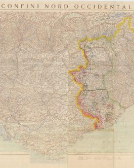
- Maps and Prints
WW2 NORTHWESTERN ITALY MILITARY MAP WITH IMPORTANT MANUSCRIPT ADDITIONS: Confini Nord Occidentali.
- 450.00€
- A fascinating and unique example of a military topographical map of Northwestern Italy, featuring original and extensive manuscript additions regarding the Italian Fascist High Command’s defensive plan made in response to the Allied invasion of the South of France in August-September 1944.
- Add to cart
-
- Maps and Prints
WWI – MONTENEGRO – INFRASTRUCTURE: Wasserwerk in Nyegusi, Montenegro. Von den Oesterreichern erbaut. Nach der Natur gez. von H. Schwarzenberger, Leipzig. Together with: Wegebau in Montenegro. Nach der Natur gez. v. Hans Schwarzenberger, L.
- 550.00€
- The two original drawings are first-hand accounts of the construction of roads and canals by Austro-Hungary, during its occupation of Montenegro in WWI. The drawings were probably made for a publication.
- Add to cart
-
- Books, History, History, Maps and Prints, Ottoman Books, Posters, Turkica
WWI – OTTOMAN EMPIRE / ANTI-ALLIED PROPAGANDA: آرش ايلرى بر مدر فلاح ايلرى
- 550.00€
- A rare ephemeral anti-British, anti-French, anti-Russian and anti-Cossack poster, made during WWI in Ottoman language by the Navy Society Broadside, 51 x 18 cm (20 x 7 inches) (soft folds, tiny holes, slightly age-toned).
- Add to cart
-
- Books, Maps and Prints, Turkey
WWI / GALLIPOLI CAMPAIGN / CAPE HELLES SECTOR / ORIGINAL MANUSCRIPT / FIELD ANNOTATIONS / LAWRENCE OF ARABIA: Map of Southern Gallipoli from a Captured Turkish Map.
- 4,500.00€
- A spectacular artefact of the Gallipoli Campaign, being an extremely rare ultra large map of the Cape Hellas-Krithia battle sector issued by T.E. Lawrence’s (later ‘Lawrence of Arabia’) map department at the Intelligence Office in Cairo, predicated upon a recently “captured” Ottoman map that was the first proper survey of this critical military zone; greatly augmented by extensive and…
- Add to cart
-
- Maps and Prints
WWI CARICATURES – OFFICER UNIFORMS
- 650.00€
- A well executed set of 11 drawings, shows high-ranking officers of the Austrian army during WWI.
- Add to cart

![WORLD WAR II / U.S.S.R. / CROATIAN PRINTING: Karta Istočnog Bojišta od Lenijngrada do Kavkaza / Naklada knjižare “Velebit” Zagreb. [Map of the Eastern Front between Leningrad and the Caucuses / Publishing House “Velebit” Zagreb].](https://pahor.at/wp-content/uploads/2020/06/65187-265x331.jpg)


![WÜRZBURG: Neuester Verkehrs-Plan der Kreishaupt- & Universitätsstadt Würzburg mit Verzeichnis der Sehenswürdigkeiten [The Newest Transportation Map of the County Capital and University City Würzburg with a List of Tourist Attractions].](https://pahor.at/wp-content/uploads/2020/06/65645-265x331.jpg)