-
- Maps and Prints, Middle East
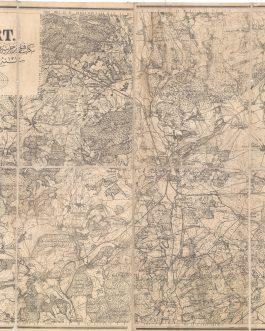
OIL-PETROLEUM HISTORY – ANGLO-PERSIAN OIL COMPANY PIPELINE / IRAN – AHWAZ, KHUZISTAN / WWI MIDDLE EAST / CALCUTTA IMPRINT: Persia. / Arabistān Province. No. 10 A. (Rough Provisional Issue 2nd Edition). [Ahwaz].
- 950.00€
- Exceedingly rare and classified - one of the first accurate surveys of the Ahwaz area of the Arabistan region of Persia (today Khuzistan Province, Iran), importantly showcasing a great stretch of the first oil pipeline in the Middle East, completed in 1912, which connected the Masjed Soleyman Oilfield with the Anglo-Persian Oil Company’s refinery at Abadan; published in the…
- Add to cart
-
- Europe
OPERATION BARBAROSSA / WORLD WAR II: 圖要ソ・獨ふ闘 [Soviet Union and Its Sole Fight]
- 850.00€
- An ephemeral Japanese map illustrating Operation Barbarossa in September 1941 highlights the complex relations between Japan, the Soviet Union, and the Axis powers during World War II. Colour lithography, 53 x 75 cm (21 x 29.8 inches) (soft folds).
- Add to cart
-
- Maps and Prints
Optical Illusions of early 19th century: Les Surprises [Surprises]
- 4,500.00€
- S. l., s.d, but France, circa 1815. 11 originally coloured engravings, each 7 x 6 cm (2.7 x 2.3 inches), 9 folded green sheets, each with printed title on the front, 2 pages of miniature text in the inner side and blank verso (of probably 12 sets), housed in original slipcase with illustrated cover (slipcase soiled with folds and scratches,…
- Add to cart
-
- Maps and Prints, Middle East
Ordnance Survey of the Peninsula of Sinai. Made with the sanction of the Right Hon: Sir John Parkington, Bart: Secretary of State for War, by Captains C.W. Wilson and H.S. Palmer under the direction of Major General Sir Henry James, R.E: F.R.S., & c., Director General of the Ordnance Survey. Part II. Maps, Plans and Sections.
- 8,500.00€
- The very rare, spectacular and complete portfolio of 8 very large format maps and 2 Topographical Cross-Sections from the ‘Ordnance Survey of the Peninsula of Sinai’ (1868-9), the ambitious exploring expedition led by the Royal Engineer captains Charles William Wilson and Henry Spencer Palmer that conducted the first scientific mapping and archaeological reconnaissance of the interior of the Sinai, both to…
- Add to cart
-
- Czech Republic, Europe, Photography
ORIENATLISM IN PRAGUE: Linguistische Verein in Prag [Linguistic Society in Prague]
- 550.00€
- A photograph of today little known Prague-based Linguistic Society, joining the prominent Austro-Hungarian researchers of Africa, as well as Indian, Arabic and Classical languages. Gelatin silver photo, contemporary mounted on thick card, manuscript numbers recto in margin, black manuscript in black ink and pencil on the back, 12 x 16,5 cm (4.7 x 6.5 inches), (minor foxing verso,…
- Add to cart
-
- Maps and Prints
ORIENTALISM: En déroute.
- 380.00€
- An elaborate large late 19th century colour photogravure of a painting of an Arabian charging army by Alfred Paris was made by a high-end Parisian gallery Boussod, Valadon & Cie.
- Add to cart
-
- Books, Geography, Maps and Prints
OTTOMAN ATLAS / LEIPZIG IMPRINT: ايلك و اورته مكتبلره محضوص جوغرافيا اطلاسى
- 550.00€
- [İlk ve Orta Mekteblere Mahsus Coğrafya Atlası / Geographical Atlas for Primary and Middle Schools] Istanbul: A. M. Karmi, Publisher - Leipzig: Wagner & Debes, Printer [1922]. 4°, [2 pp.] lithographed title page and index verso, 24 pp. chromolithographed maps, original green card binding with lettering and green cloth spine (good used condition with minor foxing and minor chips in…
- Add to cart
-
- Books, Geography, Maps and Prints, Ottoman Books, Turkica
OTTOMAN ATLAS: مكمل و مفصل جعرافيا عمومى اطلاسى
- 1,500.00€
- [Mükemmel ve Mufassal Coğrafya-yı Umumi Atlası / Complete and Detailed General Geographical Atlas] 8°, [8 pp.], 188 pp.,, [4 pp.], interleaved page between p. 28-29, 37 colour lithographed double paged maps (complete) including one plate with two maps and one folding map, original blue binding with debossed lettering and decoration (sporadic old annotations in Ottoman, one map (Asia)…
- Add to cart
-
- Africa, Asia, Australia, Maps and Prints, World Maps
OTTOMAN CARTOGRAPHY / EASTERN HEMISPHERE
- 1,500.00€
- Colour lithography, 96 x 63 cm (37.9 x 24.8 inches), (minor staining, tears repaired with modern tape and partly age-toned).
- Add to cart
-
- Maps and Prints, World Maps
OTTOMAN CARTOGRAPHY / MAP OF THE WORLD: كرۀ مسطحه [Kürre-i Müsattaha also Küre-i Müsattaha / Hemispheres of Earth lit. Flat Sphere]
- 1,800.00€
- A larger charming and seemingly unrecorded separately published map of the world in Ottoman language. Colour lithograph, 49 x 63 cm (19.3 x 24.8 inches) (light water-staining and staining on the left-hand side, otherwise in a good condition).
- Add to cart
-
- Europe, Greece, Maps and Prints, Turkey
Ottoman Cartography / Rumelia: روم ايلى شهانه خريطه سى [Rumeli-yi şahane haritası also Rumeli-i şahane haritası / Map of Principality Rumelia]
- 1,400.00€
- A gigantic (over 2 m) wall map of Rumelia (Northern Greece) made by the Ottoman Military Office Colour lithography, composed of 12 plates, originally mounted on linen and varnished, with original wooden rollers, 124 x 210 cm (48.8 x 82.7 inches) (minor staining and water-staining, light scratches, small losses of image in the middle part, rollers with chipping…
- Add to cart
-
- Asia, Books, Geography, Maps and Prints
OTTOMAN CARTOGRAPHY: Atlas & Asia
- 5,500.00€
- A unique pair of an Ottoman manuscript atlas and a map, made by a student of the Military Highschool in Bitola, in 1891, as a project for his final exams.
- Add to cart
-
- Europe, Maps and Prints, Turkey
Ottoman Cartography: استانبول بوغازى و جواري خريطه سى [İstanbul Boğazı ve civarı haritası / Map of the Bosporus and Its Surroundings]
- 1,200.00€
- A large separately published detailed map of Istanbul and the Bosporus, with their contemporary infrastructure and urbanism as developed by 1911, published by the Ottoman state press Colour lithography, 100 x 108 cm (39.4 x 42.5 inches), originally dissected in 24 segments and mounted on linen (good, used example, slightly age-toned, stained and with small ink-staining, linen with…
- Add to cart
-
- Europe, France, Maps and Prints, Ottoman Books, September 2023: 50 under 1000 EUR, Turkey, Turkica
OTTOMAN CARTOGRAPHY: بلفور Belfort
- 450.00€
- Photolithography, originally dissected in 8 segments and mounted on linen 74 x 103 cm (29.2 x 40.6 inches), (minor staining, sporadic annotations in pencil in Ottoman in margins, but overall in a good, use condition).
- Add to cart
-
- Books, Geography, Maps and Prints, Ottoman Books, Turkica
OTTOMAN GEOGRAPHIC PUBLISHING / THEMATIC CARTOGRAPHY: جغرافياى طبيعى.علمنه اساس مختصر
- 1,200.00€
- [Coğrafya-yı Tabiî İlmine Esas-ı Muhtasar / Physical Goegraphy. The Fundamentals]. A highly sophisticated Ottoman geography education book illustrated with 9 resplendently coloured plates of thematic World Maps, as well as dozens of monochrome diagrams and maps within the text; the work sponsored by American Protestant missionaries for use in their schools throughout Turkey and the Levant, issued in…
- Add to cart
-
- Books, Maps and Prints, Ottoman Books, Turkica
Ottoman Geography: المدخل في الجغرفيا [El-Medhal fî’l-Coğrafya / Introduction to Geography]
- 1,200.00€
- First popular Ottoman book on modern geography and survey 8°. 88 pp., 8 folding plates, original binding with marbled paper covers and brown cloth spine (minor staining, sporadic old annotations and underlined words, old manuscript mathematical drawing in black ink on the inner side of the front cover, binding slightly rubbed mostly around the spine with loss of…
- Add to cart
-
- Maps and Prints, Turkey
Ottoman Geological Map: اناطولى علم ارض خريطه سى [Geological Map of Anatolia].
- 1,400.00€
- Rare and Important – the first proper geological map of Turkey; a large, separately published work created by the professors Damat Kenan and Ahmet Malik Sayar, issued by the imperial printer in 1920 during the twilight of the Ottoman Empire, forming the foundation for scientific and commercial discovery during the upcoming Turkish Republican Era; printed in Ottoman Turkish text with…
- Add to cart
-
- Books, Geography, Manuscripts, Maps and Prints
OTTOMAN MANUSCRIPT SCHOOL ATLAS: جغرافياي عمومى اطلاسي
- 5,500.00€
- A unique Ottoman manuscript atlas created by a geography teacher at the Preparatory School in Bolu to address the lack of modern printed materials for geography classes. 8º. Manuscript. [14 pp.] text, 99 single- and double-page numbered maps, but actually 101 maps with nos. 10 and 11 marked twice, all maps with contemporary coloured details and verso blank, interleaved blank…
- Add to cart
-
- Balkans, Books, Bulgaria, Croatia, Europe, History, Hungary, Maps and Prints
OTTOMAN MILITARY ATLAS: محاربات مشهوره عثمانه البومى
- 3,500.00€
- [Muharebat-ı meşhure-i osmaniye albümü / Album of Famous Ottoman Battles] A monumental portfolio of the famous Ottoman battles, edited by a famous military leader Ahmed Muhtar Pacha during WWI to commemorate the glorious military past of the Ottoman Empire Folio. Title page, 33 unbound double page maps, partly printed in colours, with text, 5 single page maps,…
- Add to cart
-
- Balkans, Europe, Maps and Prints
Ottoman Mss. / Telegraph Map – Greece / North Macedonia / Albania: [No Title – Map of the Telegraph System in the Vilayets of Salonica, Monastir, Janina and Scutari].
- 1,800.00€
- A stellar, large format, original manuscript map of the telegraph system in the Ottoman Balkans, specifically in modern Greece, Northern Macedonia and Albania; with text entirely in Ottoman Turkish, it was drafted in 1889 seemingly as working document by the governmental administration that managed the empire’s telegraph network – an extraordinary survivor documenting a critical medium that revolutionized society during…
- Add to cart
-
- Books, Geography, Maps and Prints, Ottoman Books, Turkica
OTTOMAN POCKET ATLAS: ممالك عثمانيه جيب اطلاسى
- 1,200.00€
- [Memâlik-i Osmaniye Cep Atlası / The Pocket Atlas of the Ottoman Empire] 12°: 6 pp., [2 pp.], 328 pp. text in Ottoman, 64 pp. with single- or double-page maps, lithographed in colour, original dark red cloth binding with black and gold lettering and decoration- (light foxing and staining, last page age-toned, front end-papers replaced, binding slightly rubbed, but…
- Add to cart

![OIL-PETROLEUM HISTORY – ANGLO-PERSIAN OIL COMPANY PIPELINE / IRAN – AHWAZ, KHUZISTAN / WWI MIDDLE EAST / CALCUTTA IMPRINT: Persia. / Arabistān Province. No. 10 A. (Rough Provisional Issue 2nd Edition). [Ahwaz].](https://pahor.at/wp-content/uploads/2020/07/68915-265x331.jpg)
![OPERATION BARBAROSSA / WORLD WAR II: 圖要ソ・獨ふ闘 [Soviet Union and Its Sole Fight]](https://pahor.at/wp-content/uploads/2025/05/Feb25_710-copy-265x331.jpg)
![Optical Illusions of early 19th century: Les Surprises [Surprises]](https://pahor.at/wp-content/uploads/2025/02/IMG_5729-copy-265x331.jpg)

![ORIENATLISM IN PRAGUE: Linguistische Verein in Prag [Linguistic Society in Prague]](https://pahor.at/wp-content/uploads/2023/03/Foto_2023-02-22_233702-265x331.jpg)


![OTTOMAN CARTOGRAPHY – GEOGRAPHY : سملى خريطه سى جعرافجاى عمومى [General Geographical Maps]](https://pahor.at/wp-content/uploads/2020/06/2019-11-17_233736-265x331.jpg)

![OTTOMAN CARTOGRAPHY / MAP OF THE WORLD: كرۀ مسطحه [Kürre-i Müsattaha also Küre-i Müsattaha / Hemispheres of Earth lit. Flat Sphere]](https://pahor.at/wp-content/uploads/2023/10/sep23_73-copy-265x331.jpg)
![Ottoman Cartography / Rumelia: روم ايلى شهانه خريطه سى [Rumeli-yi şahane haritası also Rumeli-i şahane haritası / Map of Principality Rumelia]](https://pahor.at/wp-content/uploads/2022/06/wall-265x331.jpg)

![Ottoman Cartography: استانبول بوغازى و جواري خريطه سى [İstanbul Boğazı ve civarı haritası / Map of the Bosporus and Its Surroundings]](https://pahor.at/wp-content/uploads/2022/06/Januarmap4538-copy-265x331.jpg)
![OTTOMAN CARTOGRAPHY: مختصر تاريخى عمومى وعثماني اطلسى [Standard Atlas of Global and Ottoman History]](https://pahor.at/wp-content/uploads/2020/06/2019-12-11_232319-265x331.jpg)

![Ottoman Geography: المدخل في الجغرفيا [El-Medhal fî’l-Coğrafya / Introduction to Geography]](https://pahor.at/wp-content/uploads/2022/01/IMG_2485-copy-265x331.jpg)
![Ottoman Geological Map: اناطولى علم ارض خريطه سى [Geological Map of Anatolia].](https://pahor.at/wp-content/uploads/2021/06/69351-265x331.jpg)


![Ottoman Mss. / Telegraph Map – Greece / North Macedonia / Albania: [No Title – Map of the Telegraph System in the Vilayets of Salonica, Monastir, Janina and Scutari].](https://pahor.at/wp-content/uploads/2020/07/alb-265x331.jpg)

![OTTOMAN SCHOOL ATLAS OF AFRICA آفريقا [Arika / Africa]](https://pahor.at/wp-content/uploads/2020/06/68823-265x331.jpg)