-
- Europe, Maps and Prints, South America, Turkey
Turkey in Asia
- 150.00€
- Steel engraved playing card, overlaid in coloured stencil, blank on verso (Very Good, minor stainng verso, a small scratch and stain on the front), 97 x 65 mm (3.8 x 2.6 inches).
- Add to cart
-
- Maps and Prints
TURKEY RAILWAYS MAP / ART DECO DESIGN: Türkiye Cumhuriyeti Demiryolları.
- 550.00€
- A masterpiece of Art Deco design, being a large format separately issued map of Turkey with its railway systems, made during the height of the Kemalist Era when the republic’s railways were under the process of nationalisation and expansion, a key part of Atatürk’s political and economic agenda, published in Ankara – extremely rare.
- Add to cart
-
- Maps and Prints
TURKISH GRAPHIC DESIGN / TURKISH FEMALE DESIGNERS: Von Papen’in Hatiralari [Van Papen’s Memoirs]
- 2,800.00€
- A gigantic rare Turkish poster for the memoires of the German Nazi politician Franz von Papen, which were banned in the post-war Germany, was made by a leading Turkish Female designer Gülümser Aral. This is a hand-numbered proof state with the author’s original signature in the upper left corner.
- Add to cart
-
- Maps and Prints
TYROL / TIROL: Generalkarte der Gefürsteten Grafschaft Tyrol nebst Vorarlberg und dem Souverainen Fürstenthume Liechtenstein.
- 450.00€
- This folding map of Tyrol was the first reduced edition of a wall map from 1823, based on the new surveys of the early 19th century.
- Add to cart
-
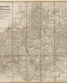
- Maps and Prints
TYROL GEOLOGICAL MAP: Geognostische Karte Tirols aufgenommen und herausgegeben auf Kosten des geognost[ischen]: montanist[ischen]: Vereins von Tirol u: Vorarlberg. 1849.
- 1,200.00€
- Rare – a monumental wall map that represents the first scientific geological map of Tyrol, as well as an advanced economic and mineralogical map, being one of the most impressive works of thematic cartography of its era.
- Add to cart
-
- Maps and Prints
UNDERGROUND PRINTING / YUGOSLAV PARTISAN CARTOGRAPHY / UNUSUAL PRINTING TECHNIQUES / CROATIA & SLOVENIA: Karta slovenskega ozemlja. 1: 200.000
- 450.00€
- A pair of rare maps, multiplied with a photographic procedure, were made by an underground partisan geodetic office during WWII and were carried on the field during operations.
- Add to cart
-
- Americas, Maps and Prints
UNITED STATES
- 200.00€
- Lithograph with original colour: 18 x 23 cm (7 x 9 inches) (soft fold, slightly age-toned and stained, small tears in margins).
- Add to cart
-
- Americas, Maps and Prints
Untitled Chart of Plymouth Bay, Massachusetts
- 4,200.00€
- The very rare first state of J.F.W. Des Barres’s beautifully rendered chart of Plymouth Bay, Massachusetts, famously the site of the Mayflower Pilgrims’ landing at ‘Plymouth Rock’; after the first scientific mapping of the bay executed by Thomas Wheeler, as part of Samuel Holland’s General Survey of the Northern District of British North America, an epic endeavour that trigonometrically charted…
- Add to cart
-
- Maps and Prints
UNUSUAL PERSPECTIVE: Hohentwiel, Baden-Württemberg
- 850.00€
- A rare unusual large originally coloured aquatint and etching showcasing the fortress Hohentwiel on the top of a volcanic dome in the German province Baden-Württemberg, as it look like before the demolition by the Napoleonic army in 1801, is presented in an unusual perspective of hemiorama.
- Add to cart
-
- Europe, Malta, Maps and Prints
VALETTA, MALTA: Plan of the Harbours and Fortifications of Valetta In the Island of Malta By Captain W. H. Smith, R.N. Knight of St. Ferdinand and Merit.
- 550.00€
- Copper engraving, 50 x 67 cm (inches) (minor age-toning and staining, old stamps and inventory numbers and a stamp Erledigt (meaning ‘Deaccessioned’).
- Add to cart
-
- Americas, Maps and Prints, South America
VENEZUELA – ORINOCO RIVER / GERMAN EXPLORERS: [Orinoco River with Flamingos]
- 3,200.00€
- Christian Anton GOERING (1836 - 1905). [Leipzig:] 1886. Water-colour on paper, mounted on later paper, sheet: 39 x 59 cm (15.3 x 23.2 inches), Drawing: 35 x 55 cm (13.8 x 21.6 inches), (light mat-burns to the margins, but otherwise in a good condition). An original drawing of the wildlife of the Orinoco River, made by the German explorer Christian…
- Add to cart
-
- Broadsides, Maps and Prints, September 2023: 50 under 1000 EUR
VENICE / PLAGUE: Illustriss. Sig. Sig. Osservandiss. Si vanno rendendo sempre maggiori li motivi di riguardo per la dilatazione del Contagio nella Morea, e Rumelia…
- 180.00€
- [The reasons for consideration for the spread of the contagion in the Morea, and Rumelia are becoming ever greater…] Broadside, letterpress on thin laid paper with a watermark, 28 x 19 cm (11 x 7.5 inches).
- Add to cart
-
- Books, Broadsides, German Books
VETERINARY MEDICINE / SUPERSTITION: Cinguli ad mensuram caelitus allatae imaginis D.P. Dominici in Soriano contra luem animalium ad collum eorum appendendi.
- 420.00€
- A rare four-page pamphlet with two somehow different solutions on fighting the pandemic of rinderpest (Lues animalium) in South Germany, in 1732. 8°, 4 pp. with a wood-cut on the last page (Very Good, uncut edges with light soiling).
- Add to cart
-
- Others
VIETNAM – TÂN AN, LONG AN PROVINCE: “Poste de Tanan”.
- 1,800.00€
- Intriguing, unique, and historically important – one of only very few surviving original manuscript plans of the archetype army bases established in key towns across French Indochina (today’s Vietnam and Cambodia) that were the foundation of colonial power in the region; the present finely rendered and highly detailed plan showcases the French army base at Tân An, a provincial capital…
- Add to cart
-
- Asia, Maps and Prints, South-East Asia
Vietnam / Cambodia / Laos (Indochina) / French Conquest Of Vietnam: Carte de L’Indo-Chine Orientale dressée par Mr. J.L. Dutreuil De Rhins publiée sous le Ministère de Mr. le Vice Amiral Jaureguiberry. Au Dépôt des Cartes et Plans de la Marine en 1881.
- 6,500.00€
- A colossal monument of the cartography of Indochina, being the grand ‘Headquarters Map’ of Vietnam, Cambodia, Laos and eastern Siam commissioned by the French Government in anticipation of their bold designs of expansion in the region that led to the Tonkin Campaign (1883-6), the complete conquest of Vietnam; showcasing by far and away the most accurate and detailed general…
- Add to cart
-
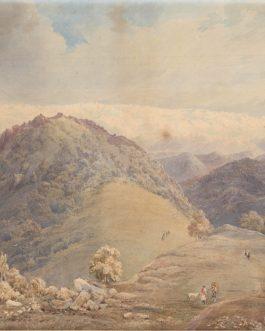
- India, Maps and Prints
View of the Foothills of the Himalayas
- 8,500.00€
- A beautifully executed mid-19th century watercolor view of the foothills of Himalayas with snowed mountain range in the background. Water-colour drawing, 34 x 49 cm (13.4 x 19.3 inches) on J Whatman wove paper, mounted on later paper (little sun-toned and with light staining and foxing, one tiny hole in the center of one of the stains, but overall…
- Add to cart
-
- Maps and Prints
VOLCANISM WORLD MAP: Südliche und Noerdliche Halbkugel der Erde nach den neuesten Entdeckungen der Vulkanischen-Linien.
- 650.00€
- An uncommon map of the World with marked vulcanic lines was published to accompany a scientific article by a German researcher of antiquity and Egyptologist Friedrich Sickler in 1812.
- Add to cart
-
- Europe, Maps and Prints, Russia
VYBORG (Выборг / VIIPURI), RUSSIA: [Proof State – Carte du Golfe de Wibourg à la Côte de Karèlie].
- 1,500.00€
- A proof state of an exceptionally rare sea chart of Vyborg Harbour, Russia, prepared for Charles-Pierre Fleurieu’s grand atlas of the Baltic Sea.
- Add to cart
-
- Australia, Maps and Prints, Oceania
Wall Map of Australia: Specialkarte von Australien in 9 Blättern nach originalen & officiellen Quellen von A. Petermann
- 680.00€
- [Special Map of Australia in 9 Sheets, after Original and Official Sources by A. Petermann] A rare, separately issued Petermann’s map of Australia on 9 sheets with old colour, originally mounted on linen and joined together in a wall map, printed by the finest German cartographic office. Original coloured lithography, 98 x 122 cm (38.6 x 48…
- Add to cart
-
- Others
WALL-MAP OF THE CAUCASUS / TIFLIS IMPRINT: Дорожная Карта Кавказскаго Края Составлена и Литографирована въ Военно-Топографическомъ Отдѣлѣ Кавказскаго Военнагоокруга.
- 4,800.00€
- A rare detailed wall-map of the Caucasus, printed in Tiflis and drafted by Military Topographic Department of the Caucasus Military District under the leadership of the prolific surveyor Hieronymus Stebnitsky
- Add to cart
-
- 16th and early 17th Century Prints, Maps and Prints
WAPPEN / COAT OF ARMS: Kardinal aus der Familie Aldobrandini (?)
- 400.00€
- Blatt mit kardinalischem Wappen, allegorischen und heiligen Figuren, gestochen von Pieter de Jode d. Ä. nach einer Zeichnung von Francesco Vanni.
- Add to cart
-
- Maps and Prints, Newly Catalogued Items: August 2022, Posters, Slavica
WARSAW UPRISING UNDERGROUND PRINTING: Warszawa Walczy żołnierska gazeta scienna. [Warsaw Fights: Soldiers’ Wall Newspaper], Nr. 40, August 19th, 1944
- 950.00€
- A very rare issue of ‘Warszawa Walczy’ [Warsaw Fights], a large illustrated broadside ‘wall newspaper’ issued by the propaganda bureau of the ‘Armia Krajowa’ [Polish Home Army] during the Warsaw Uprising, one of the most popular works published within the barricaded city to inform both resistance fighters and local residents, an especially fine example in very good condition.
- Add to cart


![TURKISH GRAPHIC DESIGN / TURKISH FEMALE DESIGNERS: Von Papen’in Hatiralari [Van Papen’s Memoirs]](https://pahor.at/wp-content/uploads/2020/06/pap-265x331.jpg)

![TYROL GEOLOGICAL MAP: Geognostische Karte Tirols aufgenommen und herausgegeben auf Kosten des geognost[ischen]: montanist[ischen]: Vereins von Tirol u: Vorarlberg. 1849.](https://pahor.at/wp-content/uploads/2020/06/tirol-265x331.jpg)


![VENEZUELA – ORINOCO RIVER / GERMAN EXPLORERS: [Orinoco River with Flamingos]](https://pahor.at/wp-content/uploads/2024/06/June24_19-copy-265x331.jpg)


![VYBORG (Выборг / VIIPURI), RUSSIA: [Proof State – Carte du Golfe de Wibourg à la Côte de Karèlie].](https://pahor.at/wp-content/uploads/2020/06/62344-265x331.jpg)


![WARSAW UPRISING UNDERGROUND PRINTING: Warszawa Walczy żołnierska gazeta scienna. [Warsaw Fights: Soldiers’ Wall Newspaper], Nr. 40, August 19th, 1944](https://pahor.at/wp-content/uploads/2022/08/Ausstt17-265x331.jpg)