-
- Decorative Prints, Maps and Prints, Old Masters, September 2023: 50 under 1000 EUR
Ex Archetypo P.P. Rubens
- 280.00€
- Copper engraving and etching, 39 x 26 cm (15.3 x 10.2 inches) (minor foxing, but overall in a good condition).
- Add to cart
-
- Maps and Prints, Moon
Exploration of the Moon / Czech Lunar Cartography: Mapy měsíčních polokoulí
- 750.00€
- [Maps of the Moon Hemispheres] A scarce set of 6 maps of the Lunar surface, based on the latest American explorations and the Soviet Lunokhod programme was made by a Czech astronomer and cartographer Antonín Rükl Book, oblong small 4°, 15 pp., stapled. 6 colour prints (each 62 x 54 cm / 24.4 x 21.3 inches), folded in…
- Add to cart
-
- Maps and Prints
FAN: Dia 19 de Marzo de 1808. En Aranjuez. Caida y Prision del Principe de la Paz.
- 950.00€
- A rare, unmounted fan leaf showcasing the Mutiny of Aranjuez and capture of Prime Minister of Spain Manuel Godoy, was made in London expressly to be exported to Spain.
- Add to cart
-
- England, Europe, History, Maps and Prints
FIRST FORENSIC MAP / FAMOUS MURDER TRIALS: Map of the Roads, near to the Spot Where Mary Ashford was Murdered
- 5,500.00€
- The probably first separately published forensic map showcases the location of a well-publicized early 19th century femicide, followed by a famous court case, which brought changes to English legal history. The author was Rowland Hill (1795-1879), an English social reformer and inventor. He is mostly famous as the inventor of the first adhesive pre-paid postal stamp, the Penny Black, in…
- Add to cart
-
- Books, Maps and Prints, Ottoman Books, Turkica
First Lithographed Folio Atlas, Printed in the Ottoman Empire: ىگى جغرافىا آطلسى [Yeñi coġrafya aṭlası / The New Geographic Atlas]
- 5,500.00€
- Folio, 42 chromolithographed double-paged maps, original chromolithographed illustrated boards, recent black cloth spine, original green endpapers (boards with minor wear, light staining, light water-staining in the lower white margin of the rear cover, tiny chips to the margins of the front cover, spine replaced, crack in the joints repaired, a tiny tear in the Great Britain map).
- Add to cart
-
- Arabic Books, Books, Geography, Maps and Prints
FIRST MODERN EGYPTIAN ATLAS OF THE WOLRD: اطلس ابتدائي للدنيا : لاستعماله في المدارس المصرية
- 2,200.00€
- [Primary Atlas of the World. For use in Egyptian Schools. First Edition] First Egyptian modern school atlas of the world, published in the year of the country’s independence, in 1922. Square 4°. Title page, 35 pp. with full page colour lithographed maps, bound in original blue card covers with title printed on front cover (title page little…
- Add to cart
-
- Bible, Books, Others, Ottoman Books, Turkica
First Printed Bible in Ottoman Language: Kitab al-Ahd al-Atiq. Kitab al-Ahd al-Jedid. Also: Kitâbü’l-ahde’l-cedide’l-mensub ilâ Rabbina İsa El-Mesih… also: Kitāb al-Ahd al-Atīq ; Kitab ül-ahd ül-cedid also: Kitâb-ı Mukaddes / The Bible [lit. The Holy Book] also: Biblia Turcica
- 2,800.00€
- The first printed translation of the Bible into Ottoman language and the basics for all the later Turkish translations of the text. Printed in Paris with 17th century Arabic types, previously used in Napoleon’s Cairo press and one of the most elegant types made in the West. Two volumes in one. 4°. [4 pp.], 7 pp., 984 pp. [2…
- Add to cart
-
- Books, Europe, Maps and Prints, Russia, Slavica
FIRST SOVIET HISTORICAL ATLAS / POLITICAL PROPAGANDA: Русский исторический Атлас [Russkiĭ istoricheskiĭ atlas / Russian Historical Atlas]
- 2,200.00€
- First Soviet historical atlas, made by one of the leading historians Konstantin Kurjashov and accompanied with an introduction by a pioneering historian of the Russian revolutionary movement Mikhail Pokrovsy, glorifying Russian economy of the past and presenting the newly founded Soviet Union as a historical self sufficient formation. Oblong folio, 12 pp. XVIII with 58 numbered maps, printed…
- Add to cart
-
- Decorative Prints, Maps and Prints
Fox
- 420.00€
- Etching with roulette, printed in sanguine, marked 3 in the upper right corner, platemark: 20,5 x 29 (8.2 x 11.4 inches), sheet: 28,5 x 37,5 cm (11.2 x 14.6 inches), (slightly stained and with light water-staining in margins).
- Add to cart
-
- Maps and Prints
FRANCE: Nova Totius Galliae Descriptio
- 850.00€
- A stunning example of a separately issued de Jode map of France was coloured in the late 16th century in the style of the frescoes of the Gallery of Maps in Vatican.
- Add to cart
-
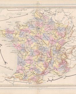
- Europe, France, Maps and Prints
France: فرانسه
- 120.00€
- A map of France from the first Ottoman lithographed atlas. Colour Lithography, 32 x 43 cm (12.6 x 17 inches), (soft fold slightly age-toned, minor wear to the margins, but overall in a good condition).
- Add to cart
-
- Maps and Prints
FREE FRENCH FORCES WW II MAP OF THE WORLD: Planisphere.
- 1,500.00€
- A gigantic rare map of the World, published by Free French Forces (FFL, Forces françaises libres) led by Charles de Gaulle, was made during the Second World War just before the major battles for control of the French colonies worldwide.
- Add to cart
-
- Africa, Maps and Prints
FRENCH EQUATORIAL AFRICA: Afrique Équatoriale Française
- 720.00€
- Colour lithograph, 120 x 79 cm (47.2 x 31.1 inches) (soft folds slightly age-toned with tiny, partly repaired holes, tiny tears in margins, overall in a good clean condition).
- Add to cart
-
- 16th and early 17th Century Prints, Maps and Prints
FUGGER – PORTRAIT: Fridericus Fugger Filius II Philippi Eduardi – Graf Friedrich Fugger (1586-1654), Herr zu Weißenhorn, Sohn des Philipp Eduard Freiherr Fugger (1546-1618)
- 750.00€
- An original 17th century hand-drawn portrait of count Friedrich Fugger, a member of the famous banking family from Augsburg.
- Add to cart
-
- Maps and Prints
GABON / REPUBLIC OF THE CONGO: Côte ouest d’Afrique. De l’estuaire du Gabon à la baie de Pointe Noire d’après les travaux de la Mission hydrographique du Gabon.
- 350.00€
- A very rare large-format survey chart of the coasts of Gabon and what is today the Republic of Congo, executed shortly before World War I by the ‘Mission hydrographique du Gabon’.
- Add to cart
-
- Maps and Prints
GALAPAGOS ISLANDS, ECUADOR: Provincia de Galápagos / Archipiélago de Colón (territorio insular).
- 750.00€
- This whiteprint photographic map, with its beautiful purple signature hue, depicts Ecuador’s Galapagos Islands. The map was made by the Instituto Geográfico Militar, the Ecuadorian military mapping institution, predicated upon the best scientific surveys. It shows all of the islands, while the legend, located under the title, gives symbols for the main towns and administrative centres; roads; airports; volcanic craters;…
- Add to cart
-
- Maps and Prints, New Acquisitions: September 2020, Turkey
GALLIPOLI / TURKEY: چناق قلعه بوغاز [Çanakkale Boğazı / Dardanelles]
- 120.00€
- Chromolithographs on thick paper. Each sheet: 11 x 15 cm (4.3 x 5.9 inches). Slightly stained, overall in a good condition
- Add to cart
-
- Maps and Prints, New Acquisitions: September 2020, Turkey
GALLIPOLI CAMPAIGN – BATTLES OF KRITHIA (ALÇITEPE): [Untitled Ottoman Mimeographed WWI Military Map of the Southern Part of the Gallipoli Peninsula].
- 420.00€
- A rare ephemeral artefact from the Gallipoli Campaign of World War I, being a mimeographed map made in the field by Ottoman soldiers, depicting the theatre of the Battles of Krithia (Alçitepe), a series of four major altercations fought between British Imperial-French forces and the Turks between April and August 1915. Mimeograph in purple (Very Good, old vertical centrefold,…
- Add to cart
-
- Maps and Prints
GENERAL GEORGE ELIOT: Le Général Elliot. Quo nihil majus meliusve. Dédié a son Excellence Milord Visomte de Torrington…
- 650.00€
- A decorative originally coloured mezzotint portrait showcasing General George Eliott, the Governor of Gibraltar with a siege in the background, was drafted by a Brussels-based artist Pierre de Glimes, and printed by Johan Fredrik Martin, a Swedish specialist in mezzotint stipple engraving and colour printing.
- Add to cart


![First Lithographed Folio Atlas, Printed in the Ottoman Empire: ىگى جغرافىا آطلسى [Yeñi coġrafya aṭlası / The New Geographic Atlas]](https://pahor.at/wp-content/uploads/2023/01/IMG_3944-copy-265x331.jpg)

![First Printed Bible in Ottoman Language: Kitab al-Ahd al-Atiq. Kitab al-Ahd al-Jedid. Also: Kitâbü’l-ahde’l-cedide’l-mensub ilâ Rabbina İsa El-Mesih… also: Kitāb al-Ahd al-Atīq ; Kitab ül-ahd ül-cedid also: Kitâb-ı Mukaddes / The Bible [lit. The Holy Book] also: Biblia Turcica](https://pahor.at/wp-content/uploads/2023/07/Ali2-265x331.jpg)
![FIRST SOVIET HISTORICAL ATLAS / POLITICAL PROPAGANDA: Русский исторический Атлас [Russkiĭ istoricheskiĭ atlas / Russian Historical Atlas]](https://pahor.at/wp-content/uploads/2023/01/IMG_4590-1-copy-265x331.jpg)


![GALLIPOLI / TURKEY: چناق قلعه بوغاز [Çanakkale Boğazı / Dardanelles]](https://pahor.at/wp-content/uploads/2020/08/68977-1-265x331.jpg)
![GALLIPOLI CAMPAIGN – BATTLES OF KRITHIA (ALÇITEPE): [Untitled Ottoman Mimeographed WWI Military Map of the Southern Part of the Gallipoli Peninsula].](https://pahor.at/wp-content/uploads/2020/09/gali-265x331.jpg)
