-
- Maps and Prints
ISTANBUL, ARCHEOLOGY: Cisterns
- 360.00€
- A set of 5 original photographs, most probably made during WWI, showcase the byzantine capitals of four different cisterns of Istanbul.
- Add to cart
-
- Europe, Maps and Prints, Turkey
Istanbul, Fatih
- 4,500.00€
- Anon. Istanbul, Fatih [S. l., S. d., but Istanbul: between 1923-1928]. Black ink and water-colours in blue, orange, green and red on tracing paper, irregular format, but at widest points 142 x 160 cm (55.9 x 63 inches), originally dissected in segments and mounted on linen (minor tears and folds to the edges of segments, but overall in a good…
- Add to cart
-
- Maps and Prints, Turkey
ISTANBUL: Nouveau plan de Constantinople et des environs
- 4,200.00€
- A rare chromolithographed plan of Istanbul with charming wrappers, printed in Zürich and published by a German book shop in Istanbul. Chromolithographed map, originally dissected in 15 segments and mounted on paper, 63 x 73 cm (24.8 x 28.7 inches), folded in original illustrated cromolithographed wrappers 8° (Slightly age-toned, minor chips to the edges of segments, sporadic annotations…
- Add to cart
-
- Maps and Prints
ISTANBUL: Управление военных Топографов. Стамбул.
- 200.00€
- A rare large chromolithographed map of Turkey with Istanbul in the middle was published in Russian Cyrillic as a part of a detailed series of maps of European Russia, made in the late 1920s by the Soviet Military Topographic Office, under the command of the Red Army.
- Add to cart
-
- Maps and Prints
ISTRIA: Nouvelle Carte de l’Istrie.
- 400.00€
- Rare smaller Santini's version of the map of Istria.
- Add to cart
-
- Maps and Prints
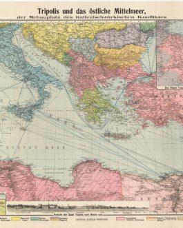
ITALO-TURKISH WAR (1911-2): Karte von Tripolis und dem östlichen Mittelmeer, dem Schauplatz des italienisch-türkischen Konfliktes.
- 220.00€
- A scarce separately-issued, large-format map of the theatre of the Italo-Turkish War (1911-2), an important precursor to WWI during which Italy conquered Libya and Greece’s Dodecanese Islands from the Ottoman Empire.
- Add to cart
-
- Maps and Prints, Turkey
IZMIR, TURKEY: Coastline and inshore soundings west of Sas Burnu from Turkish Governmant Charts of 1941
- 150.00€
- Lithograph with a pasted down instructions and manuscript annotations in pencil and pink colour, 70 x 102 cm (27.6 x 40.1 inches) (Very Good, soft folds).
- Add to cart
-
- Maps and Prints
JAIPUR, RAJASTHAN, INDIA: Touristenkarte von Jaipur [& on verso:] Touristenkarte von Dschaipur [Udaipur] / Touristenkarte von Chitorgargh [Chittorgarh].
- 250.00€
- A highly attractive double-sided tourist map of Jaipur, Rajashathan - the ‘enlightened’ city of Northern India, with verso maps of Udaipur and Chittorgarh.
- Add to cart
-
- Asia, Maps and Prints, South-East Asia
JAKARTA (BATAVIA), INDONESIA: [A Pair of Original Watercolour Views of Important Colonial Buildings in Batavia (Jakarta), Dutch East Indies (Indonesia)].
- 950.00€
- A pair of attractive and richly composed original 19th century watercolour views of two of Batavia’s (Jakarta, Indonesia) most important colonial buildings, being the ‘Willemskerk’ and the Residence of the Commander-in-Chief of the Dutch Army in the East Indies; executed by “D. Colleart” – a rare find, as very few original manuscript views of Batavia from the era survive.#…
- Add to cart
-
- Americas, Caribbean, Maps and Prints
JAMAICA – PAIR (2) ORIGINAL MSS. VIEWS / SLAVERY / IMMEDIATE POST- EMANCIPATION ERA
- 4,500.00€
- A pair (2) of historically important original manuscript sepia views, depicting 1) the Great House and windmill of Perrins’s Estate, one of Jamaica’s leading sugar plantations, and 2) the St. Dorothy’s (or the ‘Tamarind Tree’) Church, established in 1681, which is today one of the oldest and most culturally significant churches in Jamaica; executed to an unusually high degree…
- Add to cart
-
- Maps and Prints, World Maps
JAPAN – CARTOGRAPHIC PROPAGANDA / WORLD WAR I / RUSSO-JAPANESE WAR / STELLAR MAP DESIGN: 世界大戰紀念地圖 明治之偉跡 大正之偉業
- 3,200.00€
- [Commemorative Map of the World War. The Great Footprint of Meiji, the Great Undertaking of Taisho]. An extremely rare and very large format Japanese propaganda map, a grand pageant of imagery celebrating Japan’s military triumphs during the Meiji and Taishō Eras that made her an Asian-Pacific superpower and gave her a great empire, showcasing elements of the just-concluded World…
- Add to cart
-
- Maps and Prints
JAPAN – Nagasaki. Shinkö Nagasaki-no-zu.
- 1,400.00€
- An especially attractive large-format early 19th Century map of Nagasaki, then Japan’s ‘Window to the World,’ printed in Nagasaki by Baikö-dö.
- Add to cart
-
- Asia, Japan, Maps and Prints
JAPAN – SENDAI: [仙台市と城の地図 / Map of Sendai City and Castle].
- 2,500.00€
- A unique and historically important artefact, being a highly detailed and beautifully coloured original manuscript map of Sendai, then the largest city in Japan north of Edo (Tokyo), and a major commercial centre of around 50,000 residents, built just across the river form the famous Aoba Castle, labelling all streeta, outlining all major cadastral lots and noting all key…
- Add to cart
-
- Asia, Japan, Maps and Prints
Japan – Tokyo – Great Kantō Earthquake & Fire: 大正十二年九月 帝都大震火災系統地図
- 1,400.00€
- [Map of the Fire of Tokyo. Edited by the Relief Information Bureau of the Tokyo Imperial University] A very large and impressive map chronicling how the Great Kanto Earthquake (1923) and the resulting inferno, that was the greatest urban fire to date, destroyed much of Tokyo, based upon analysis conducted by academics at the Tokyo Imperial University, it…
- Add to cart
-
- Others
JAPANESE MEIJI WORLD MAP: 萬國明細全圖 / 改訂新版. [Kaisei shinpan bankoku meisai zenzu / Detailed Map of the World / Revised New Edition].
- 1,200.00€
- A rare and highly decorative Meiji Era World Map, an important landmark in the Japanese adoption of Western cartographic methods, as it one of the first Japanese maps to feature charts showing the comparative heights of the world’s main mountains and the lengths of its longest rivers, clearly used for pedagogic purposes, fulfilling the major Meiji changes to the Japanese…
- Add to cart
-
- Maps and Prints, World Maps
JAPANESE PICTORIAL MAP: 世界新漫画鳥瞰圖 [New Pictorial Bird’s Eye View of the World]
- 1,200.00€
- A 1923 pictorial map of the world by a Japanese manga artist Ogawa Jihei. Colour lithograph, 78 x 110 cm (30.7 x 43.3 inches) (soft folds with small holes partly repaired with tape, tiny tears in margins, otherwise in a good condition).
- Add to cart
-
- Maps and Prints
JERUSALEM: Amir’s Pictorial Map.
- 200.00€
- A highly decorative pictorial map of Jerusalem, was made by an Israeli illustrator and map maker Immanuel Blaushild, and published in Tel Aviv in 1969.
- Add to cart
-
- Photography
Josip Broz-Tito: 4 original photographs, ca 1950 -1978.
- 350.00€
- A set of original fotos of Yugoslavian president Josib-Broz-Tito was made by Yugoslav official photographers, for the central agency, which distributed the copies to the national and international newspapers.
- Add to cart

![ISTANBUL – ARCHAEOLOGY: Χάρτης των Χερσαίων Τειχών της Μεςαιωνικης Κωνσταντινουπόλεως [Map of the Land Walls of Medieval Constantinople]](https://pahor.at/wp-content/uploads/2020/06/68830_2-265x331.jpg)

![ISTANBUL ARCHAEOLOGY AND ART HISTORY: Topkapı Sarayı müzesine bağlı tarihi türbeler [Historical Tombs Attached to Topkapı Palace Museum]](https://pahor.at/wp-content/uploads/2020/06/ott_3-265x331.jpg)


![JAIPUR, RAJASTHAN, INDIA: Touristenkarte von Jaipur [& on verso:] Touristenkarte von Dschaipur [Udaipur] / Touristenkarte von Chitorgargh [Chittorgarh].](https://pahor.at/wp-content/uploads/2020/06/65076_1-265x331.jpg)
![JAKARTA (BATAVIA), INDONESIA: [A Pair of Original Watercolour Views of Important Colonial Buildings in Batavia (Jakarta), Dutch East Indies (Indonesia)].](https://pahor.at/wp-content/uploads/2022/07/bat2-265x331.jpg)


![JAPAN – SENDAI: [仙台市と城の地図 / Map of Sendai City and Castle].](https://pahor.at/wp-content/uploads/2023/01/Augustomap76-copy-265x331.jpg)

![JAPANESE MEIJI WORLD MAP: 萬國明細全圖 / 改訂新版. [Kaisei shinpan bankoku meisai zenzu / Detailed Map of the World / Revised New Edition].](https://pahor.at/wp-content/uploads/2023/01/Decemscan6-copy-265x331.jpg)
![JAPANESE PICTORIAL MAP: 世界新漫画鳥瞰圖 [New Pictorial Bird’s Eye View of the World]](https://pahor.at/wp-content/uploads/2023/03/Febup2-copy-265x331.jpg)