-
- Maps and Prints
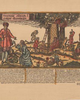
LUBOK NO. 210, RUSSIA: Голански лѣкаръ і добрьі аптѣкаръ [Golanski lekar’’ і dobr’і aptekar’’ / A Golan Doctor and a Good Pharmacist.
- 320.00€
- A rare 19th century photolithoraphed lubok (Russian popular broadside) with text in early cyrillic alphabet and with original colour shows a variation of the motiv of a fountain of youth.
- Add to cart
-
- Maps and Prints
LUBOK No. 70: Повесть О купце и Шутѣ и Трактирщике сь женою [POVEST’ O KUPCE I ŠUTE I TRAKTIRŜIKE S’ ŽENOJU / The Story of a Merchant and a Joker and an Innkeeper with his Wife].
- 320.00€
- A rare 19th century photolithoraphed lubok (Russian popular broadside) with text in early Cyrillic alphabet and with original colour shows a restaurant scene accompanied by comical poem in Russian language.
- Add to cart
-
- Maps and Prints
LUBOK: Иванъ Яковлевичъ Курейша Въ Преображенской больници вь Москви [Ivan’’ Jakovlevič’’ Kurejša V’’ Preobraženskoj bol’nici v’ Moskvi / Ivan Yakovlevich Kureysha v Preobrazhenskaya Hospital in Moscow].
- 550.00€
- A rare 19th century photolithoraphed lubok (Russian popular broadside) with text in early cyrillic alphabet and with original colour shows a holy fool and a clairvoyant Ivan Yakovlevich Koreisha.
- Add to cart
-
-
- Maps and Prints
LUXEMBURG / LUXEMBOURG: Lutzenbur-gii Montuosissimi ac saltuosissimi ducatus.
- 2,200.00€
- A stunning example of a separately issued first map of the duchy of Luxembourg, published by Gerard de Jode, was coloured in the late 16th century in the style of the frescoes of the Gallery of Maps in Vatican.
- Add to cart
-
- Africa, Madagscar, Maps and Prints
MADAGASCAR – Anantson̈o (St. Augustin’s Bay) & Toliara (Tullea): The Bays of St. Augustin and Tullea, on the Western Coasts of Madagascar, Surveyed in 1755 and 1768.
- 500.00€
- A fine and scarce sea chart of St. Augustin’s (Anantson̈o) and Tullea (Toliara) bays, amongst the finest anchorages on the west coast of Madagascar, published by the leading chartmakers of Laurie & Whittle.
- Add to cart
-
- Africa, Madagscar, Maps and Prints
MADAGASCAR – Anantson̈o (St. Augustin’s Bay): A Chart of St. Augustin’s Bay, on the Island Madagascar As Surveyed by Wm. Nichelson, (Master of His Majesty’s Ship Elizabeth) in the Year 1758.
- 750.00€
- Very rare – the first edition of Captain William Nichelson’s masterly large-format sea chart of St. Augustin’s Bay, Madagascar, a key harbour on the Mozambique Channel, along the route between Europe and India, first issued in the 1767 edition of William Herbert’s important atlas, ‘A New Directory for the East Indies’.
- Add to cart
-
- Maps and Prints
MAINZ, Explosion of the Pulverturm
- 1,200.00€
- Three original drawings of the destruction of Mainz after the explosion of the Pulverturm, the powder tower, were made in-situ by an English journalist.
- Add to cart
-
- Asia, Maps and Prints, South-East Asia
Malaysia Wall Map / Chinese Malaysians / Hong Kong Imprint: Newest Wall Map of Federation of Malaya. / 馬來亞聯合邦掛圖
- 1,500.00€
- A very rare wall map of the Federation of Malaya (today’s peninsular Malaysia) made only the year after its independence from Britain, an entirely bilingual work (Chinese-English) executed by a Chinese draftsman, Li Menphy, and published in Hong Kong for the benefit of Malaya’s large Chinese population and the many Hong Kongers who had strong connections to that country…
- Add to cart
-
- Maps and Prints
MALAYSIA: Handbook of the Federated Malay States …Second Edition.
- 850.00€
- Scarce – the definitive official overview of the Federated Malay States at the beginning of the 20th Century, during the rubber and tin boom; richly illustrated with 5 folding maps and 7 photographic plates, by Sir H. Conway Belfield, the British Resident in Selangor.
- Add to cart
-
- Maps and Prints
MANHATTAN, New York: Hotel Bristol’s Motorist’s Guide.
- 180.00€
- Art-Deco map of Manhattan, made for the World Fair in New York in 1939.
- Add to cart
-
- Maps and Prints
MANHATTAN, New York: New York. Hotel Wellington.
- 220.00€
- Art-Deco map of Manhattan, made for the World Fair in New York in 1939.
- Add to cart
-
- Americas, Maps and Prints
Manhattan. New York
- 350.00€
- Colour lithograph, 45,5 x 68 cm (18 x 26.8 inches), verso text and colour images (soft folds, otherwise in a good condition.
- Add to cart
-
- Maps and Prints
MANUSCRIPT MAP: Fort-Louis, France: Plan du Port Louis du Rhin… (and verso: For Louis comme il est).
- 380.00€
- A detailed hand drawing in pencil and red and black ink from circa 1700 shows Fort-Louis in France, close to the German border.
- Add to cart
-
- Africa, Maps and Prints, Middle East
Map of Lower Egypt
- 1,800.00€
- The very rare first edition of the foundational map of the British colonial regime in Egypt; created by the Intelligence Department of the War Office on the eve of the Anglo-Egyptian War (1882), whereby Britain forcibly made Egypt a protectorate, so gaining dominance over the Suez Canal; predicated upon the best sources, the very large four-sheet work was the…
- Add to cart
-
- Maps and Prints, September 2023: 50 under 1000 EUR, World Maps
MAP OF THE WORLD: ΠΑΓΚΟΣΜΙΟΣ ΓΕΩΓΡΑΦΙΚΟΣ ΧΑΡΤΗΣ. [World Geographical Map]
- 280.00€
- Colour lithography, 26 x 38 cm (10.2 x 15 inches) (soft fold, minor staining).
- Add to cart
-
- Others
Map of Victoria, Hong Kong. / 最新香港詳細街道全圖
- 1,800.00€
- A rare and highly detailed bilingual map of Victoria (Central), depicting the governmental and commercial epicentre of Hong Kong as it appeared on the eve of the Roaring ’20s, labeling every street and outlining every key building and institution, published in Shanghai by the Guoguang Shuju printing house. Photolithograph, small contemporary mss. annotation in pink crayon, with printed pastedown…
- Add to cart
-
- Africa, Maps and Prints, Middle East
MAP PRINTED ON SILK / OBJECT D’ART / ALEXANDRIA, EGYPT / NAPOLEONIC CAMPAIGN IN EGYPT: A Plan of the Operations of the British Forces in Egypt from the Landing in Aboukir Bay on the 8th of March to the Battle of Alexandria March 21st inclusive.
- 3,500.00€
- An exquisite ‘objet d’art’, being a unique example of William Faden’s map of the Battles of Abukir and Alexandria (1801), France’s ‘last stand’ in Egypt, printed on silk with details richly embroidered in coloured silk thread, clearly a prestation piece made for a highly important figure. Copper engraving on silk with details contemporarily heightened in embroidery of coloured silk thread, contemporarily…
- Add to cart
-
- Americas, Central America, Maps and Prints
Mapa de la Republica de Nicaragua / Levantado por orden de su Exa. el Presidente Cap.n General Martinez por Maximiliano de Sonnenstern 1863.
- 5,200.00€
- Maximilian von SONNENSTERN (1819 – 1895). Paris: Broise & Tiheffry, 1863. Lithograph with original outline hand colour, dissected into 24 sections and mounted upon original linen, contemporary map seller’s label of ‘Auguste Logerot / Paris’ to linen verso folding into forest green original patterned cloth covers with gilt title to front cover (Very Good, lovely original colours, overall clean and…
- Add to cart
-
- Americas, Maps and Prints, South America
Mappa della Provincia di S. Paolo organizzata dalla Società Promotrice d’Immigrazione di S. Paolo 1886.
- 1,400.00€
- BRAZIL - SÃO PAULO STATE / ITALIAN IMMIGRATION TO BRAZIL: José C. de CARVALHO, Cartographer. / ORGANIZZATA DALLA SOCIETÀ PROMOTRICE D’IMMIGRAZIONE DI S. PAOLO, Sponsor. Rio de Janeiro: Lith. Paulo Robin & C.a, 1886. Colour lithograph, mounted upon modern linen, with register on verso preserving the view of the contemporary handstamp of a ‘Pietro Milanese’, a Genoa…
- Add to cart

![LUBOK No. 70: Повесть О купце и Шутѣ и Трактирщике сь женою [POVEST’ O KUPCE I ŠUTE I TRAKTIRŜIKE S’ ŽENOJU / The Story of a Merchant and a Joker and an Innkeeper with his Wife].](https://pahor.at/wp-content/uploads/2020/06/65544-265x331.jpg)

![LUBOK: Иванъ Яковлевичъ Курейша Въ Преображенской больници вь Москви [Ivan’’ Jakovlevič’’ Kurejša V’’ Preobraženskoj bol’nici v’ Moskvi / Ivan Yakovlevich Kureysha v Preobrazhenskaya Hospital in Moscow].](https://pahor.at/wp-content/uploads/2020/06/65643-265x331.jpg)
![LUBOK: Календарь повԑемԑтвенњіи. О̄потребленїе предложенныхъ четырехъ таблицъ на которыхъ кратко собранный неисходимыи калемдарь [Calendar of the Earth. Use of the presented four plates on which are gathered short necessary [information] for calendar]](https://pahor.at/wp-content/uploads/2020/06/65041-265x331.jpg)


![MAP OF THE WORLD: ΠΑΓΚΟΣΜΙΟΣ ΓΕΩΓΡΑΦΙΚΟΣ ΧΑΡΤΗΣ. [World Geographical Map]](https://pahor.at/wp-content/uploads/2023/08/70304-265x331.jpg)


