-
- Maps and Prints
Les Surprises [Surprises]
- 4,500.00€
- A seemingly unrecorded collection of cards featuring transparent illuminations that depict demons, illusions, and portraits of Napoleon Bonaparte, accompanied by sheets containing macabre tales and other stories, created during the height of gothic novels' popularity. 11 originally coloured engravings, each 7 x 6 cm (2.7 x 2.3 inches), 9 folded green sheets, each with printed title on the front,…
- Add to cart
-
- Maps and Prints
LETTER OPENERS: Verschiedene Papiermesser aus der 2. Hälfte des 19. Jahrhunderts
- 850.00€
- Set of fascinating letter openers by the Eastern Telegraph Company, decorated with maps, calendar, measurements etc.
- Add to cart
-
- Maps and Prints
LETTERHEAD ON PARCHMENT: House of Bourbon-Two Sicilies
- 300.00€
- A rare empty official letterhead on parchment, with arms of the house of Bourbon-Two Sicilies.
- Add to cart
-
- Maps and Prints, Middle East
LEVANT & HEJAZ RAILWAY: جغرافياى عسكرى و عثمانى درسلرينه مخصوص سوريه قطعة سى
- 3,200.00€
- عثمان نورى [Osman Nuri, Sabık Coğrafya-yı Askeri Muavini Piyade Kol Ağası / Senior Chief Military Cartographer for the Infantry]. جغرافياى عسكرى و عثمانى درسلرينه مخصوص سوريه قطعة سى [Part of Syria for Specific Military and Ottoman Geographical Operations / Lessons] Inset Map: حجاز دميريولى كذركاهى [Hicaz demiryolu güzergah / Route of the Hejaz Railway] Istanbul: مكتب حربيه مطبعه سى [Maktaba…
- Add to cart
-
- Africa, Maps and Prints, Newly Catalogued Items: August 2022
LIBYA / ITALO-TURKISH WAR / PATRIOTIC PROPAGANDA: Nuova pianta geografica della Tripolitania e Cirenaica con le conquiste italiane.
- 480.00€
- A rare and highly attractive work of patriotic propaganda, being a large map of Libya celebrating Italy’s invasion of the country during the Italo-Turkish War (1911-2), created early in the conflict by the Societá editoriale milanese. Colour print (Very Good, clean and bright, some wear along old folds, some minor marginal staining, far right margin, once bearing additional…
- Add to cart
-
- Africa, Books, Maps and Prints, New Acquisitions: December 2020
LIBYA GEOLOGICAL MAP / OIL-PETROLEUM INDUSTRY: Geologic Map of the Kingdom of Libya Compiled by Louis C. Conant and Gus H. Goudarzi under the joint sponsorship of the Kingdom of Libya and the Agency for International Development, U. S. Department of State. / خريطة جيولوجية للمملكة الليبية
- 750.00€
- The first edition of the first comprehensive, scientifically accurate geological map of Libya, a grand, bilingual (English - Arabic) separately issued production primarily made to aid the country’s burgeoning oil industry; the result of a collaboration between Louis Conant and Gus Goudarzi, two of America’s most esteemed geologists, fulfilling a joint project of the U.S. State Department and the pro-Western…
- Add to cart
-
- Maps and Prints
LIEGE, BEGIUM – ABRAHAM ORTELIUS: Leodiensis Dioecesis Typus
- 520.00€
- A stunning example of a rare, separately issued map of Burgundy by Abraham Ortelius, was coloured in the late 16th century in the style of the frescoes of the Gallery of Maps in Vatican.
- Add to cart
-
- Maps and Prints
LIPOWA, Poland: Umgegend von Lindewiese.
- 1,800.00€
- Exquisitely executed painted view of Lipowa landscape, Poland, by acclaimed Polish artist Arthur Blaschnik. One of Blaschnik’s relatively few original artworks relating to his native Polish region.
- Add to cart
-
- Maps and Prints
LISBON HARBOUR, Portugal: A Topographical Chart of the Entrance to the River Tagus describing the Coast from Cape Roca to Sacarem with the Harbour and Environs of Lisbon. The Nautical Part if from a Survey taken in 1806 by W. Chapman, Master of the Royal
- 800.00€
- An Excellent sea chart of Lisbon Harbour, made under the direction of the British Admiralty, considered the finest and most accurate nautical map of the Mouth of the Tagus of the first half of the 19th Century.
- Add to cart
-
- Maps and Prints
LISBON, PORTUGAL: A Topographical Chart of the Entrance of the River Tagus describing the Coast from Cape Roca to Sacavem; with the Harbour and Environs of Lisbon. The Nautical Part is from a Survey taken in 1806 by W. Chapman, Master of the Royal Navy; a
- 380.00€
- A rare and exceptionally fine sea chart of Lisbon Harbour and surrounding waters, predicated upon surveys made during the Peninsular War and subsequently updated by the Royal Navy.
- Add to cart
-
- Books, Maps and Prints, Ottoman Books, Turkica
LITHOGRAPHED RUZNAME – OTTOMAN EMPIRE
- 2,600.00€
- A remarkably fine example of an Ottoman Tanzimat Era lithographed calendar scroll (ruzname), headed with an image of a clock, with original rollers and wrappers Paper Scroll (rotulus), mounted upon an original wood roller original patterned brown paper wrappers (Very Good, a few minor tears and light staining, tears in the upper part repaired with modern tape) 205…
- Add to cart
-
- Maps and Prints
LJUBLJANA / TRANSPORTATION MAP / WALL MAP: Načrt Ljubljane in okolice. Stanje Ljubljane, kakršno bi bilo, če ne bi bilo železniške ovire
- 450.00€
- A large wall map in photo-reproduction and manuscript with a plan for the new railroad system of Ljubljana.
- Add to cart
-
- Europe, Italy, Maps and Prints, New Acquisitions: October 2020, Slovenia
LJUBLJANA-TRIESTE RAILROAD: Karte der k.k. Staats-Eisenbahn zwischen Laibach und Triest. Sr. Excellenz dem Hochgeborenen Herrn Gustav Grafen Chorinsky, Freiherrn von Ledske…
- 2,200.00€
- [Map of the K. K. State Railway between Ljubljana and Trieste. To His Excellency the Noble Gustav Count Chorinsky, Baron von Ledske…] A rare, charming map of the railroad between Ljubljana and Trieste was lithographed in Ljubljana, possibly at the occasion of the opening of the line. Lithograph, 66 x 41 cm (26 x 16.1 inches), originally dissected in…
- Add to cart
-
- Maps and Prints
LJUBLJANA: Laibacher Zeitung. Fest-Ausgabe. Bei der Allerhöchsten Anwesenheit Ihrer kaiserl königl. Apost. Majestäten in Laibach. Am. 19. November 1856
- 750.00€
- Extremely rare folding one sheet pamphlet issued at the time of a visit of the emperor Franz Joseph I to Ljubljana on Novemeber 19th 1856.
- Add to cart
-
- Africa, Maps and Prints, September 2023: 50 under 1000 EUR
London Atlas Map of West Africa [Title on the Cover]. West Africa Showing the British Possessions [Title on the Map].
- 120.00€
- Lithographed map with original hand colour, dissected into 18 sections and mounted upon original linen, folding into original dark green cloth covers with publisher’s pastedown label, publisher’s advertisements as front endpaper (Wrappers slightly pale with worm holes on the spine, internally clean), 51 x 70 cm (20 x 27.6 inches).
- Add to cart
-
- Maps and Prints
LOUISBOURG, Nova Scotia, Canada: Plan de la Ville et du Port de Louisbourg. Levé en 1756 suivant l’original conservé au Dépôt Général des Cartes, Plans et Journaux de la Marine. Pour le Service des Vaisseaux du Roi. Par ordre de M. de Sartine Cons
- 850.00€
- A fine large-format map of Louisbourg (Cape Breton) especially prepared for the use of the French Royal Navy during the American Revolutionary War.
- Add to cart
-
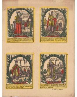
- Maps and Prints
LUBKI Nr. 152 & 165: Худое домоправителство… [and] лосепешать скорай домой …
- 320.00€
- Two uncut rare 19th century photolithoraphed lubki (Russian popular broadsides) with text in early cyrillic alphabet and with original colour show popular motives from Russian folklore.
- Add to cart
-
- Maps and Prints
LUBOK 186 [Russian Popular Broadside].
- 320.00€
- A rare lubok (Russian popular broadside) with text in early cyrillic script and with original colour shows popular motives from Russian folklore.
- Add to cart
-
- Maps and Prints
LUBOK 64 [Russian Popular Broadside].
- 320.00€
- A rare lubok (Russian popular broadside) with text in early cyrillic script and with original colour shows popular motives from Russian folklore.
- Add to cart
-
- Maps and Prints
LUBOK 698 [Russian Popular Broadside].
- 320.00€
- A rare lubok (Russian popular broadside) with text in early cyrillic script and with original colour shows popular motives from Russian folklore.
- Add to cart
-
- Maps and Prints
LUBOK 72 [Russian Popular Broadside].
- 320.00€
- A rare lubok (Russian popular broadside) with text in early cyrillic script and with original colour shows popular motives from Russian folklore.
- Add to cart
-
- Maps and Prints
LUBOK 98 [Russian Popular Broadside].
- 320.00€
- A rare lubok (Russian popular broadside) with text in early cyrillic script and with original colour shows popular motives from Russian folklore.
- Add to cart
-
- Maps and Prints
LUBOK No. 15, RUSSIA: Lubok with Sibyls and Icons from Life of Jesus.
- 320.00€
- A rare 19th century photolithoraphed lubok (Russian popular broadside) with original colour ahows four scenes from the life of Jesus, accompanied with figures of sibyls from ancient Greece.
- Add to cart

![Les Surprises [Surprises]](https://pahor.at/wp-content/uploads/2025/06/IMG_5561-2-copy-265x331.jpg)


![London Atlas Map of West Africa [Title on the Cover]. West Africa Showing the British Possessions [Title on the Map].](https://pahor.at/wp-content/uploads/2023/08/70281-265x331.jpg)

![LUBKI Nr. 152 & 165: Худое домоправителство… [and] лосепешать скорай домой …](https://pahor.at/wp-content/uploads/2020/06/65551-265x331.jpg)
![LUBOK 186 [Russian Popular Broadside].](https://pahor.at/wp-content/uploads/2020/06/65548-265x331.jpg)
![LUBOK 64 [Russian Popular Broadside].](https://pahor.at/wp-content/uploads/2020/06/65547-265x331.jpg)
![LUBOK 698 [Russian Popular Broadside].](https://pahor.at/wp-content/uploads/2020/06/65553-265x331.jpg)
![LUBOK 72 [Russian Popular Broadside].](https://pahor.at/wp-content/uploads/2020/06/65545-265x331.jpg)
![LUBOK 98 [Russian Popular Broadside].](https://pahor.at/wp-content/uploads/2020/06/65549-265x331.jpg)