
Home » Maps and Prints »
Maps and Prints

SARAJEVO: Grand Hotel Central.
200.00€
A photograph of the social life around the Café of the Grand Hotel Central in Sarajevo, Bosnia, was made on the eve of WWI by a photographer Walter Tausch, who recorded the last images of Archduke Franz Ferdinand of Austria and his wife minutes before their assassination in 1914 and documented the arrest of Gavrilo Princip.

SAUDI ARABIA: Complete Master Plan and Feasibility Study Portfolio…
11,500.00€
Published at the beginning of the Kingdom's historic First Five-Year Development Plan (1970–1975), this exceptionally rare, gigantic thematic atlas details the infrastructure plans for areas around Riyadh and Dhahran—roughly covering the eastern portions of today's Riyadh and Eastern Provinces—with a primary focus on transportation, oil fields, and spatial geography.

SERBIA
120.00€
A map from Umûm Vilayât-ı Şâhâneyi Hâvi Küçük Atlas - Umûmî Küçük Atlas (General Small Atlas) Chromolithograph. 9 x 13,5 cm (3.5 x 5.3 inches).

SERBIA – WWI: Balkán háboru térképe [Balkan War Map].
300.00€
A rare folding map of Serbia and Belgrade, was printed in Budapest two days after the Austro-Hungarians declared war on Serbia, what marked the beginning of the World War I. - One of the earliest maps showing the theater of the WW I.


SHANGHAI, CHINA : [Complete Set of 5 Cadastral Masterplans of the Shanghai International Settlement:] Shanghai Municipality. Land Assessment Schedules made in Pursuance of Resolution VI passed at the Annual Meeting of Ratepayers, of April 13, 1927. / Central District / Northern District / Eastern District / Western District.
14,500.00€
Highly important and seemingly unrecorded – as best as we are aware the only complete printed cadastral masterplan of the International Settlement of Shanghai in its expanded (post-1899) form, thus including 5 separate maps, respectively showcasing the Central (The Bund), Northern (Hongkou) and Western Districts, while the Eastern District is covered by 2 of the maps; the plans were made…

SHIPS: SS Porto. French Icebreaker Mikula.
220.00€
Two original drawings on one sheet showcasing SS Porto and icebreaker Mikula were made by a British, probably during a military campaign in the Black Sea or Eastern Mediterranean Sea, circa 1920.

SHKODËR COUNTY, NORTHERN ALBANIA OTTOMAN CARTOGRAPHY / SIEGE OF SHKODËR
2,200.00€
[The view of the Hut Hills, where the 3rd Regiment, which was dispatched from Istanbul, which was in charge of protecting the city from the attack of the rebels, defended for 45 days until the force needed in Iskodra was replenished] [and:] [Headquarters of the 2nd Division of the Ishkodra Forces. The Rrapshë Plain] Unique late Ottoman bird’s…

SINGAPORE & BORNEO
320.00€
A map from Umûm Vilayât-ı Şâhâneyi Hâvi Küçük Atlas - Umûmî Küçük Atlas (General Small Atlas) Chromolithograph. 9 x 13,5 cm (3.5 x 5.3 inches).

SINGAPORE & SUMATRA: صوماطرا اطيه سى [Island Sumatra]
230.00€
Chromolithograph. 10 x 13,5 cm (4 x 5.3 inches). Slightly stained, overall in a good condition.


Sketch Map of River Hooghly from Hooghly to Ulabaria showing Jute and Cotton Mills, Factories, Presses and Port Commissioners Ferry Service Route 1920. Published under the authority of the Calcutta Port Commissioners by the Deputy Conservator of the Port.
1,800.00€
S. GHOSE. / CALCUTTA PORT COMMISSIONERS. Calcutta: Survey of India Office, 1920. Heliozincograph in red and black, dissected into sections and mounted upon original cloth with original marbled endpapers, mss. owner’s inscription of “Saunders 29-8-[19]21” to cloth verso (Good, some mild staining due to the natural oxidization of the glue from the cloth backing), 85 x 59.5 cm (33.5…
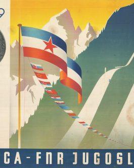
SKI-JUMPING POSTER: 1949 Planica FNR Jugoslavija
680.00€
A rare magnificent well-designed large poster for a ski-jumping competition of 1949 at the legendary ski-jumping field in Planica, the place of 13 world records since 1934.

SLAVERY / ABOLITIONISM SÃO TOMÉ E PRÍNCIPE – THE “SLAVE-GROWN COCOA CONTROVERSY”: “Impressos e Noticías etc, etc. da Sociedade Anti-Esclavagista Portugueza”.
4,200.00€
A valuable and unique archive concerning the “Slave-Grown Cocoa Controversy”, a great scandal that made global headlines in the years leading up to WWI, whereupon Portugal was found to be allowing the owners of the famed cocoa plantations of the islands of São Tomé and Príncipe to literally enslave black migrant workers, mainly from Angola; the scandal embroiled the three…

SLOVAKIA / SKIING: Za sluncem a snehem do Nizkych Tater
950.00€
Offset lithograph, 95 x 64 cm (37.4 x 25.2 inches), (minor abrasions at edges, otherwise in a good condition).

SLOVENIA, STATISTICAL ATLAS: Statistični atlas Ljudske Republike Slovenije [Statistical Atlas of the People’s Republic of Slovenia].
350.00€
First post WWII detailed statistical atlas of Slovenia with black and white photographs, was published by the Statistical Office of the People’s Republic, as a basis for a national strategy for economic development.


SOUTH AFRICA – Eastern Cape / XHOSA WARS: [Untitled Manuscript Sketch Map of the ‘Eastern Frontier’ of the Cape Colony / Grahamstown-Great Fish River Area].
750.00€
An original manuscript sketch map of the Grahamstown-Great Fish River region of South Africa, the strategically critical ‘Eastern Frontier’ of the Cape Colony, made immediately in the wake of the Sixth European-Xhosa War (1834-6).

SOUTH AFRICA – EIGHTH EUROPEAN-XHOSA WAR (1850-3): “1851 / The Outspan. in Kaffarland”.
3,500.00€
An amazing survivor, being an original manuscript caricature drafted during the Eighth European-Xhosa War (1850-3), one of the century-long series of brutal conflicts between Dutch, and more recently British, forces and the formidable Xhosa nation for control over the Eastern Cape Frontier, South Africa’s ‘Wild, Wild East’; involving a very clever use of imagery and dialogue, the caricature shows two…

SOUTH AFRICA : قاپ [Cape]
120.00€
A map from Umûm Vilayât-ı Şâhâneyi Hâvi Küçük Atlas - Umûmî Küçük Atlas (General Small Atlas) Chromolithograph. 9 x 13,5 cm (3.5 x 5.3 inches).

SOUTH AFRICA / AUSTRALIANA: “Track of H.M.S. Tamer round the Cape of Good Hope” [manuscript title, pasted over original printed title: Track of the Ship Hannah John Lamb R. N. Commander Round the Cape of Good Hope in June & July 1822.]
950.00€
A unique example of a very rare chart of South Africa, with a curious Australian connection! Commander John Lamb’s chart showing the 1822 route of his ship ‘Hannah’, fighting the Agulhas Current rounding the Cape of Good Hope; but this example with a manuscript pastedown title regarding the route of the ‘H.M.S. Tamar’, plus manuscript traces of its route,…

SOUTH AFRICA / GOLD MINING / ENGINEERS’ ‘MASTER PLAN’: Kinross Mines Ltd. – Underground Plan – 1:2,500.
2,500.00€
A colossal ‘master plan’ of the Kinross Gold Mine in Transvaal (measuring 1.9 x 1.7 metres!), made by engineers around 1970 to showcase every detail of the immense subterranean world of one of South Africa’s largest and most productive gold operations; the mine since became world famous for the 1986 Kinross Mining Disaster, which highlighted the Apartheid regime’s horrific record…

SOUTH AFRICA / LESOTHO / EARLY ORANGE FREE STATE IMPRINT / ‘INTELLECTUAL PROPAGANDA’: Correspondence between the Governor of the Cape of Good Hope and the President of the Orange Free State, with Annexes thereto relative to the Basuto War and Convention e
1,200.00€
An extremely rare early Bloemfontein imprint featuring seminal primary sources concerning the end of the Orange Free State-Basotho Wars which secured the Anglo-Afrikaner balance of power in the region, as well as the security of what would become Lesotho, commissioned by the Volksraad of the Orange Free State as a work of ‘intellectual propaganda’ advancing its national claims.

SOUTH AFRICA / PHOTOGRAPHY / SIEGE OF MAFEKING / BADEN-POWELL, FOUNDER OF THE BOY SCOUTS: Collection of 37 Glass Photographic Slides of the Siege of Mafeking (1899 – 1900).
2,800.00€
A fascinating and lovely artefact from the Siege of Mafeking (1899 - 1900), the highest profile event of the Second Anglo-Boer War and one of the greatest global media spectacles of the fin de siècle era, being a set of 37 diapositive glass photographic slides made from contemporary photos apparently by Frank Whiteley, the Mayor of Mafeking and one…

SOUTH AFRICA & MADAGASCAR: افريقاى جنوبى و شرفى
200.00€
Lithograph with original colour: 18 x 23 cm (7 x 9 inches) (soft fold, slightly age-toned and stained).

SOUTH AFRICA – CAPE TOWN FORTIFICATIONS – THE PRINCE OF WALES BLOCKHOUSE – ORIGINAL MANUSCRIPT PLANS
3,200.00€
A set of original, exquisitely executed manuscript plans of the blockhouse of the Prince of Wales Battery, one of the key components of the elaborate new defensive system that the British constructed around Cape Town (South Africa) during their first occupation of the colony from 1795 to 1803; drafted by Captain (later Major-General) George Bridges, the commanding Royal Engineer…

SOUTH AFRICA: POTCHEFSTROOM (North West Province). Map of Potchefstroom shewing Fifteen Mile Radius.
850.00€
An Exceptionally rare - seemingly unrecorded – and impressively large ‘Sunprint’ or cyanotype map on cotton cloth, depicting Major Robert Lyle McClintock’s advanced topographical survey of the environs of Potchefstroom, South Africa, executed in the period following the Second Anglo-Boer War, made in Potchefstroom after the original survey composed in Pretoria.

SOUTH AMERICA: يكى جنوبى امريقا [New South America]
550.00€
A very rare, large format, separately issued map of South America, that is perhaps the last great map of the continent to be printed in Ottoman Turkish script, with attractive colours and adorned with the flags of major African states and colonies, published in Istanbul for the Kitabhane-yi Sudi bookshop Colour off-set print (Good, some light staining, wear and…

South Pole, Australia and South America
180.00€
Chromolithograph. 8,5 x 13,5 cm (3.3 x 5.3 inches). Slightly stained, overall in a good condition

SOVIET ECONOMIC ATLAS: Атлас СССР для средней школы: курс экономической географии [Atlas of SSSR for Gymnasiums: Course for Economical History].
320.00€
A detailed economic atlas for gymnasiums in the Soviet Union, made at the height of the Cold War, showcases the country as a progressive unity, far ahead of the capitalistic countries.

SPAIN – BALEARIC ISLANDS / FINE POLISH PRINTING: Krótkie ale fundamentalne opisanie Balearyjskich i Pythyuzyjskich Wysp Majorca, Minorca, Ivica i Formentera z dowodnieyszych i nowszych relacyi zebrane i do drukowania z niemieckiego.
2,800.00€
Extremely rare – a lovely gem that represents the first detailed description of the Balearic Islands in Polish, issued in the wake of the Fall of Minorca (1756), by the Jesuit Press of Warsaw, including a fine sheet of maps engraved by Bartłomiej Strachowski.

SPAIN – MÁLAGA IMPRINT EPHEMERA: C.D.O. La Escuela de Niños Abates de la Ciudad de Malaga.
700.00€
Extremely rare – a broadside souvenir commemorating the ascension of King Carlos IV and Queen María Luisa to the Spanish throne, published in Málaga by Francisco de la Torre.

SPAIN – BADAJOZ / NAPOLEONIC WARS MANUSCRIPT MAP: [Untitled Manuscript Plan of the Siege of Badajoz (1812)].
650.00€
An exquisitely drafted, coloured manuscript plan of the Siege of Badajoz (1812), one of the seminal events of the Peninsular War.

SPAIN, PORTUGAL: Nova Descriptio Hispaniae
2,400.00€
A stunning example of a rare, separately issued map of Spain and Portugal by Gerard de Jode, was coloured in the late 16th century in the style of the frescoes of the Gallery of Mapsin Vatican.

SRI LANKA – GALLE and SOUTHWEST COAST: Trigonometrical Survey of the West Coast of Ceylon, Executed by order of the Madras Government, By Lieuts. F.T. Powell & R. Ethersey, I.N. Sheet IV. From Point De Galle to Dondra Head by T.H. Twynam, Master Assistant
750.00€
Exceedingly rare – one of only 2 known examples - the first publication of the earliest systematic trigonometrical survey of the south-western coast of Sri Lanka, a self-contained section of a four-part series of charts resulting from Lieutenants Frederick Thomas Powell and Richard Ethersey’s masterly survey of the ‘West Coast of Ceylon’, undertaken upon the orders of the East…

SRI LANKA – KALPITIYA and BATTICALOA: Calpentyn Road on the West Coast of Ceylon [with] The East Coast of Ceylon from Venlos Bay to Batecalo with the Banks, Rocks, Soundings & ca.
400.00€
Very Rare - a sheet featuring a pair of charts of Kalpitiya and Batticaloa, Sri Lanka, from Sayer & Bennett’s rare sea atlas ‘The East-India Pilot, or Oriental Navigator’.

SRI LANKA: A View of the Agricultural, Commercial, and Financial Interests of Ceylon. With an Appendix; Containing Some of the Principal Laws and Usages of the Candians; Port and Custom House Regulations; Tables of Exports and Imports, Publish Revenue and
1,500.00€
Rare – the only work on the economics and economic history of Ceylon (Sri Lanka) from the early British colonial period, by Anthony Bertolacci, the island’s Corsican-born Auditor-General, featuring information of immense historical value published nowhere else, augmented by the first edition of Captain Gaulterus Schneider’s revolutionary map of Ceylon – the first scientific survey of the island.

SRI LANKA: سيلان آطه سى [Seylan Atası]
180.00€
Chromolithograph. 9 x 13,5 cm (3.5 x 5.3 inches). Minor staining, overall in a good condition.

ST. LUCIA / DOMINICA – ORIGINAL MSS. MAPS: “Gros Islet Bay St. Lucia.” [and] “Prince Ruperts Bay Dominica.”
4,500.00€
A stellar pair of original manuscript sea charts, on a single sheet, being surveys by James Langley, the Master of the ‘HMS Scamander’, showing 1) Gros Islet Bay, a critical fortified harbour near the northern point of St. Lucia that was chosen by the famed Admiral George Rodney a key base of the Royal Navy; and 2) Prince Rupert’s Bay…

ST. PAUL’S SHIPWRECK, MALTA: S. Pauls Bay.
750.00€
An unusual small early 19th century manuscript map with annotations shows the alleged location of St. Paul’s shipwreck, discussed in Acts of the Saints.

ST. THOMAS, U.S. VIRGIN ISLANDS / CHARLOTTE AMALIA HARBOR / JEWS IN THE WEST INDIES: West Indies – Virgin Islands. Harbour of St. Thomas surveyed by Lieut. G. B. Lawrence, R.N. 1851… Corrections by Captain Nares, H.M.S. Challenger, 1873.
620.00€
An attractive large format sea chart of Charlotte Amalie Harbor, St. Thomas, Virgin Islands, predicated upon detailed surveys made by Britain’s Royal Navy in 1851, but here updated to 1912, only five years before the Danish Virgin Islands were sold to the United States, featuring a wealth of details on the town and its environs including major public institutions, Jewish…


SUDAN / EGYPT – MAHDIST WAR – PAIR OF MAPS:
1,200.00€
A pair of fine, separately issued maps that represent the first broadly accurate general mapping of Southern Egypt and Northern Sudan; important masterpieces of frontier military cartography printed during the Siege of Khartoum, and which served as the definitive maps used by Anglo-Egyptian forces for the remainder of the Mahdist War (1881-99), the epic contest for control of Sudan;…

SUDAN / RAILWAYS: [Sudan Governor-General Sir Charles Gordon’s Original Manuscript Report submitted to the Egyptian Public Works Minister Ali Pasha Mubarak prosing a scheme to save the embattled Egypt-Khartoum Railway project, illustrated with an original Mss. Map].
8,200.00€
Charles George GORDON, aka “Gordon of Khartoum” (1833 - 1884). Manuscript, [Khartoum, Autumn 1879]. An original manuscript of extraordinary quality and interest, being a report written by the legendary British soldier-adventurer Sir Charles George Gordon, aka “Gordon of Khartoum”, in his capacity as Governor-General of Sudan, in the service of the Egyptian Khedive, articulating his well-conceived plan to…

SUDAN – KHARTOUM-OMDURMAN: Egyptian Sudan. The Nile from Metemma to Khartum. Compiled in the Intelligence Division, War Office. July 1898.
750.00€
A rare and important work predicated upon the latest reconnaissance that was the most advanced map of the Khartoum-Omdurman region of Sudan to date, made by the British War Office as a vital strategic aide in the immediate run up to the Battle of Omdurman (September 2, 1898), the decisive showdown of the Mahdist War, the 18-year-long contest for…

Sundials & Paper Instruments
2,200.00€
A delightful unique collection featuring a manuscript on sundials and two paper instruments, all contained in a contemporary marbled paper case.

SUPERSTITION: MOLES AND PERSONALITY – OTTOMAN EMPIRE
550.00€
Anon. [S. l., S. d., but Ottoman Empire, probably Istanbul, late 19th century]. Black ink on paper, 31,5 x 21 cm (inches), (tiny tears in folds and margins light foxing).

SURINAM – PARAMARIBO / AERIAL CARTOGRAPHY: Stadsplattegrond van Paramaribo, schaal 1:10.000 / Townmap of Paramaribo / Plan de ville de Paramaribo / Mapa da cidade Paramaribo / Mapa de la ciudad Paramaribo / Stadtplan Paramaribo.
550.00€
RESERVED An intriguing late colonial era map of Paramaribo, Surinam, in the form of an aerial photograph of the city tinted in green superimposed with information identifying all streets, 208 named key sites, neighborhoods, railways, and bus and ferry routes; created by the colony’s foremost geographer and geologist, Henk Dahlberg, working for the Surinam’s Central Bureau of Air…

SURINAM – PARAMARIBO / WEST INDIES URBANISM: Paramaribo 1916-17.
950.00€
A highly, detailed, large format separately issued official plan of Paramaribo, showcasing the capital of Surinam on the eve of the Roaring ’20s, when it was a fast growing mart of commodities and one of the most ethnically diverse cities in the world, depicting all significant aspects of infrastructure, land use and key institutions (including churches, mosques, Hindu temples and…

SURINAME – PARAMARIBO: [Figuratieve Plattegrond der Stad Paramaribo (Kolonie Suriname, Zuid-Amerika) in 9 Kaarten met een plan der geheele stad op schaal. door A.J. Meyer, Ambtenaar bij de Belastingen].
2,800.00€
Exceedingly rare - 1 of only 3 known examples - the first ultra-detailed printed city plan of Paramaribo, the capital of Surinam, issued only 12 years after the abolition of slavery, when the city’s was experiencing dramatic physical and population growth due the influx of emancipated slaves migrating from rural plantations; made by Albertus Jacobus Meijer, a tax collector, who…

SYRIA – ALEPPO / MIDDLE EAST / OTTOMAN CARTOGRAPHY: حلب ولآيت [Halep Viayet / Vilayet Aleppo]
160.00€
Postcard. Lithography in colour (Very Good, slightly age-toned, verso small later annotations in the corner, a tiny piece of corner missing) 13 x 9 cm (5.11 x 3.5 inches).


SYRIA / LEBANON / PALESTINE / ISRAEL / TURKEY / JORDAN / WORLD WAR I / RAILWAYS: Syrien und Mesopotamien: zur Darstellung der Reise des Dr. Max Freiherrn von Oppenheim vom Mittelmeer zum Persischen Golf, 1893 / I: Westliches Blatt / Eisenbahn-Nachträge 19
550.00€
The scarce World War I edition of the stellar map Heinrich Kiepert originally made to illustrate Max Freiherr von Oppenheim’s travels in the Levant, but here revised as a special ‘Railway Edition’ to depict the extensive, new railroad systems in the region that played major role in the on-going conflict.

SYRIA: سوریه ولايتى [Suriye Vilayeti]
180.00€
Postcard. Lithography in colour (Very Good, slightly age-toned, tiny tears and chips in margins ) 10 x 14cm (5.11 x 3.5 inches).


SZIGETVÁR, HUNGARY: سيكتوار محاصى سى [SIEGE OF SZIGETVÁR].
450.00€
A very rare broadside with Ottoman script showing the siege of Szigetvár was made in the series of large separately published maps by the Turkish War Office the late Hamidian period as a part of intellectual propaganda to revive patriotic sentiment.

TAIWAN / BUENOS AIRES IMPRINT: Eine Reise in das Innere der insel Formosa und die erste Besteigung des Niitakayama (Mount Morrison), Weihnachten 1898.
1,200.00€
A fascinating account of the German economist and ethnographer Karl Theodor Stöpel’s tour of Taiwan which occurred just after the island was taken over by Japan, during which he witnessed the island rapid’s economic-political transition and the local Chinese’s rebellion against the new regime, as well as being one of the earliest scientific missions deep into the island’s interior,…

TAJIKISTAN – MINERALOGICAL & ECONOMICAL STUDY: Таджикистан. Краткий политико-экономический очерк Таджикской ССР [Tajikistan. Brief Political and Economic Essay of the Tajik SSR.].
550.00€
The first economical research of Tajik Soviet Socialist Republic with a large mineralogical map was made by the first Chairman of the Council of People s Commissars of Tajikistan, who was later executed for treason.

talian Fascist Atlas for Slovenian Primary Schools: Zemljepisni atlas za ljudske šole. Slovenska izdaja
120.00€
[Geographical Atlas for Primary Schools. Slovenian Edition] A rare official atlas for primary schools, issued in Slovenian language by the Fascist Italy, after its taking over the central Slovenian region in World War II in 1941. Small 8°. 20 pp. with colour maps and black and white photographs, original wrappers with lettering (good used condition with old…

TALLINN, Estonia: Tallinna. Linna Plaan. [Tallinn. City Map.]
350.00€
A colourful map in Estonian language shows Tallinn, the capital of the Estonian Republic, between two world wars, in 1937, three years before the Soviet invasion. The map also includes streets, which were planned to be constructed in the following years.

TANZANIA / RWANDA / BURUNDI – WORLD WAR I IN EAST AFRICA: German East Africa. Scale 1:2,000,000 or 1.014 Inches = 32 Miles.
1,200.00€
A seemingly unrecorded special ‘emergency’ issue of Max Moisel’s groundbreaking map of Deutsch-Ostafrika (today’s mainland Tanzania, Rwanda and Burundi), issued in haste by British War Office immediately following the outbreak of World War I, whereupon East Africa became a surprisingly intense conflict theatre; the present example bearing evidence of field use, featuring contemporary manuscript additions. Photolithographic print, with contemporary…


TASHKENT, UZBEKISTAN: Тaшкент.
250.00€
A large colourful Soviet map shows Tashkent, Uzbekistan, rebuilt in a contemporary socrealistic style after an earthquake of 1966, which erased almost the entire city.

Tataria
150.00€
Steel engraved playing card, overlaid in coloured stencil, blank on verso (Very Good, minor stainng verso, a small scratch and stain on the front), 97 x 65 mm (3.8 x 2.6 inches).


TEHRAN CONFERENCE / WWII / YUGOSLAVIA: Naši narodi so složni v vojni in v miru, ki bo vojni sledil. Stalin – Roosevelt – Churchill.
450.00€
[Our nations shall work together in war and in the peace that will follow] A rare, seemingly unrecorded poster with portraits of Joseph Stalin, Franklin Roosevelt and Winston Churchill was printed in Slovenian language in Great Britain, probably to be distributed in the Yugoslav Partisan camps on the territory of the liberated territory in Italy. Lithograph, 48 x…

TEHRAN, IRAN: Central Map of Tehran.
750.00€
A stunning lithographed map, designed by Abbas Sahab - Father of Iran's Cartography, in English and partly in Farsi, was the third map by this author, showing a modern city of Tehran in 1964, at the beginning of the White Revolution, which mondernised the infrastructure of Iran.


TEHRAN, IRAN: TEHRAN.
350.00€
A rare Abbas Sahab's miniature version of a map of Tehran was published in 1958, soon after the 1953 Iranian coup d'état.

Textile Design: Archive of Drafts for Textile Patterns
1,600.00€
A collection of 19 large drafts for textile patterns by an Austrian designer Ludmila Hellmann-Kavalla

THAILAND – WWI VICTORY PROCLAMATION BROADSIDE: Royal Proclamation On the occasion of the Great Victory Of The Allies. (Translation).
1,500.00€
An extremely rare broadside issued by the Royal Court of King Vajiravudh (Rama VI) of Siam, celebrating the Allied victory in World War I, translated into the English language and published in Bangkok for the benefit of Siam’s Western expatriate population.

THE AMERICAS – CARTOGRAPHIC PLAYING CARD: ‘America’ from The Court Game of Geography.
250.00€
A very rare cartographic playing card featuring a map of the Americas, being the ‘Ace of Spades’.

THE BALKANS, AUSTRIA AND EASTERN GERMANY: Quinta Europe Tabula.
5,500.00€
The rare map of the Balkans, Austria and Southern Germany from the ‘Rome Ptolemy’, a monument in the early history of engraving and the cartography of Central and Southeastern Europe.

The British Possessions in West Africa
180.00€
Stanford's map of West Africa. Lithographed map with original hand colour, dissected into 21 sections and mounted upon original linen, folding into original red cloth covers with publisher’s pastedown label, publisher’s advertisements as front endpaper (Good, clean example), 52 x 77 cm (20.5 x 30.3 inches).

The Calcutta Journal, or, Political, Commercial, and Literary Gazette, vol. III, no. 71.
1,200.00€
[Including the Maps:] Sketch of the positions taken up before the Fort of Nowah 1819 and Plan & Sketch of the Fort of Nowah 1819. An important issue of ‘The Calcutta Journal’, one of the highest quality, most influential and controversial newspapers in India of the first third of the 19th century, notably featuring an authoritative and detailed eyewitness…


THE LEVANT (ISRAEL / LEBANON / SYRIA / TURKEY) – PAIR: SEA CHART & VIEW: A Chart of the Coast of Syria, from Ancient Joppa To Iskenderoon. By Capt. Edw.d Smith, R.N. Taken during a Cruise in The Right Hon.ble Lord Francis Edgerton’s Yacht, Menai. May & J
850.00€
The only known surviving examples of a pair of fine nautical works by Captain Edward Smith, R.N., being a large-format sea chart of the Levant, accompanied by a sheet of nautical views of the same coast, based on Smith’s reconnaissance of the coast aboard the yacht ‘Menai’ in the spring of 1840.

The Pleasant Isle of Barbados
380.00€
A charming post war pictorial map of Barbados Colour lithography, 63 x 50 cm (24.8 x 19.7 inches) (soft folds, minor staining, but overall in a good condition).

THE SIEGE OF KAHUN, PAKISTAN / FIRST ANGLO-AFGHAN WAR: Nuffoosk Pass / Attempted relief of Kahun on the 31st Augt. 1840.
3,400.00€
Thomas WINGATE (1807-1869) (att.). [S. l., S. d., but probably Pakistan or India, 1840]. A large original drawing showcasing the the Siege of Kahun in Balochistan during the First Anglo-Afghan War, probably drafted by an amateur artist and officer Thomas Wingate, later active in Australia. Watercolours on paper 28,5 x 41cm (11.2 x 16.1 inches), mounted with margins under old…

THE WORLD / MEIJI JAPAN’S ‘AWAKENING’: 重訂万国全図 [Jutei bankoku zenzu / Complete Map of All Countries].
5,500.00€
A colossal composition that has the distinction of being the second ever official Japanese map of the world, with the present edition revised to epitomize the Japanese geographic conception of the globe near the beginning of the Meiji Era, when the country embarked upon a program of hyper-industrialization and international interaction; one of the iconic Japanese maps of the…

THEATER / AUSTRIA / MUNICH: Donnerstag den 15. März 1832 wird in dem k. k. Hofburgtheater von den k. k. HofSchauspielern aufgeführt. Der Graf von Burgund. Schauspiel in vier Aufzügen, von August v. Kotzebue
200.00€
[On Thursday, March 15th, 1832 in the Imperial Theater by the Actors of the Court. Der Graf von Burgund, Play in Four Acts, by August von Kotzebue].

THEATER BROADSIDE / FEMALE CIRCUS PERFORMERS: Theater in Düsseldorf, Heute, Freitag, den 19.April 1831 wird der aus St. Petersburg bei seiner Rückreise dahin von Paris hier angekommene Kaiserlich Russische Hofkünstler und Professor der natürlichen Magie Carel Iwanowitsch v. Mekold… Kriegsgöttin Minerva…
250.00€
[Theater in Düsseldorf, Today, Friday, April 19, 1831 the Imperial Russian court artist and professor of natural magic Carel Ivanovich von Mekold, who arrived here from St. Petersburg on his return journey from Paris. …War Goddess Minerva…] Düsseldorf: April 1831. Broadside, 35 x 21,5 cm (13.8 x 8.5 inches), (soft fold, otherwise in a good condition) (#70376). A playbill for…


THEATRE PLAYBILL: THEATRE-ROYAL, WORCESTER: …the Celebrated Distin Family, the Unrivalled Brass Quintette Performers…
680.00€
A rare playbill from the Theatre-Royal in Worcester presents The Celebrated Distin family, a famous family of musicians, who played a vital role in popularization of Saxhorns and brass music in England and the United States, with a major influence on the American Civil War bands.

THEATRE PLAYBILL: THEATRE-ROYAL, WORCESTER: Second Concert of the Celebrated Distin Family.
680.00€
A rare playbill from the Theatre-Royal in Worcester presents The Celebrated Distin family, a famous family of musicians, who played a vital role in popularization of Saxhorns and brass music in England and the United States, with a major influence on the American Civil War bands.

THEATRE PLAYBILL: THEATRE-ROYAL, WORCESTER: Second Concert of the Celebrated Distin Family.
450.00€
A rare playbill from the Theatre-Royal in Worcester presents The Celebrated Distin family, a famous family of musicians, who played a vital role in popularization of Saxhorns and brass music in England and the United States, with a major influence on the American Civil War bands.

THEATRE PLAYBILL: THEATRE-ROYAL, WORCESTER: The Celebrated Distin Family, and Their still Increasing Attraction.
680.00€
A rare playbill from the Theatre-Royal in Worcester presents The Celebrated Distin family, a famous family of musicians, who played a vital role in popularization of Saxhorns and brass music in England and the United States, with a major influence on the American Civil War bands.

THEATRE PLAYBILL: THEATRE-ROYAL, WORCESTER: The Celebrated Distin Family, and Their still Increasing Attraction.
680.00€
A rare playbill from the Theatre-Royal in Worcester presents The Celebrated Distin family, a famous family of musicians, who played a vital role in popularization of Saxhorns and brass music in England and the United States, with a major influence on the American Civil War bands.


THEATRE PLAYBILL: THEATRE, COVENTRY. Second Night!!… The Celebrated Distin Family.
950.00€
A rare playbill from the Coventry Theatre, presents The Celebrated Distin family, a famous family of musicians, who played a vital role in popularization of Saxhorns and brass music in England and the United States, with a major influence on the American Civil War bands.

THEATRE PLAYBILL: THEATRE, COVENTRY.The Easter Week… The Celebrated Distin Family.
950.00€
A rare playbill from the Coventry Theatre, presenting The Celebrated Distin family, a famous family of musicians, who played a vital role in popularization of Saxhorns and brass music in England and the United States, with a major influence on the American Civil War bands.


